Racconigi
| Racconigi | ||
|---|---|---|
| Comune | ||
| Città di Racconigi | ||
|
The central "Carlo Alberto Square" and the Town Hall | ||
| ||
 Racconigi Location of Racconigi in Italy | ||
| Coordinates: 44°46′N 07°41′E / 44.767°N 7.683°ECoordinates: 44°46′N 07°41′E / 44.767°N 7.683°E | ||
| Country | Italy | |
| Region | Piedmont | |
| Province | Cuneo (CN) | |
| Frazioni | Canapile, Berroni, Migliabruna, Oia, Parruccia, San Lorenzo, Streppe, Tagliata | |
| Government | ||
| • Mayor | Adriano Tosello (from 2002-05-26) | |
| Area | ||
| • Total | 48.03 km2 (18.54 sq mi) | |
| Elevation | 260 m (850 ft) | |
| Population (December 31, 2004) | ||
| • Total | 9,886 | |
| • Density | 210/km2 (530/sq mi) | |
| Demonym | Racconigesi | |
| Time zone | CET (UTC+1) | |
| • Summer (DST) | CEST (UTC+2) | |
| Postal code | 12035 | |
| Dialing code | 0172 | |
| Patron saint | St. John the Baptist | |
| Website | Official website | |
Racconigi is a town and comune in Piedmont, Italy. It is located in the province of Cuneo, 40 kilometres (25 mi) south of Turin, and 50 kilometres (31 mi) north of Cuneo by rail.
History
The town was founded in medieval times. It was a possession of the marquisses of Saluzzo, of the princes of Acaia and of the Savoy-Carignano.
Geography
Racconigi is located in the northern borders of its province with the one of Turin. The town borders with the municipalities of Caramagna Piemonte, Carmagnola (TO), Casalgrasso, Cavallerleone, Cavallermaggiore, Lombriasco (TO), Murello, Polonghera and Sommariva del Bosco. Its municipal hamlets (frazioni) are Canapile, Berroni, Migliabruna, Oia, Parruccia, San Lorenzo, Streppe and Tagliata.
Economy
The economy is mostly based on agriculture, production of milk and meat, and industrial working of metal sheets.
Main sights

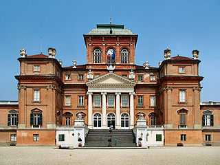
- Castle of Racconigi: This royal residence built in 1570 on the basis of an earlier castle which dated to the beginning of the second millennium. The large park was laid out in 1755 by the French gardener Molard from designs by Le Nôtre, and enlarged in 1835.[1] The castle became the summer residence of the King of Italy in 1901,[1] and part of the World Heritage Site Residences of the Royal House of Savoy in 1997.
- San Giovanni Battista: Church
- San Domenico and Santa Maria Maggiore: Baroque churches
- LIPU: the Italian League for the Protection of Birds, established the Centro Anatidi e Cicogne in 1985 in a large farmhouse near the castle as a site for the reintroduction of the white stork, which became extinct in Italy as a breeding species at the beginning of the eighteenth century. The site now includes a breeding centre for various endangered species of ducks, geese and swans—notably the white-headed duck which has been extinct in Italy since 1976—and an area of wetland where visitors can observe such migrants as black-winged stilt, little ringed plover and black-tailed godwit.
Notable people
- Umberto II of Italy, last King of Italy
Twin towns
-
 Bonneville (France) (1990)
 -
 Cascais (Portugal) (2003)
References
- ↑ 1.0 1.1 ‘Racconigi’, in Encyclopædia Britannica (1911).
External links
![]() Media related to Racconigi at Wikimedia Commons
Media related to Racconigi at Wikimedia Commons
- Il Castello di Racconigi (English)
- Centro Anatidi e Cicogne (English)
