Qutuni
| Qutuni | |
|---|---|
| Tiklla | |
 Qutuni Peru | |
| Elevation | 5,897 m (19,347 ft)[1] |
| Location | |
| Location | Lima Region, Peru |
| Range | Andes |
| Coordinates | 12°15′23″S 75°57′24″W / 12.25639°S 75.95667°WCoordinates: 12°15′23″S 75°57′24″W / 12.25639°S 75.95667°W |
| Climbing | |
| First ascent | 1-1963 from west: From E., difficult-1966: S.E. face to 5600m (ice)-1987[2] |
Qutuni[2][3][4] (Aymara qutu heap, pile, -ni a suffix to indicate ownership, "the one with a heap", hispanicized spelling Cotoni, Cutuni), also called Tiklla (Quechua tiklla two-colored,[5] / eyelash[6] hispanicized Ticcla, Ticlla), is a mountain in the Andes of Peru, about 5,897 metres (19,347 ft) high. Strictly speaking the popular name Tiklla refers to a group of peaks of the Qutuni-Tiklla cirque.[2] The highest mountain of the massif is named Qutuni.
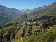
It is located in the Lima Region, Yauyos Province, on the border of the districts Ayaviri, Miraflores and Tanta. Qutuni lies southeast of the lake Tikllaqucha and the mountain Aqupallqa, northeast of the mountain Wayna Qutuni ("young Qutuni") and north of the mountain Llunk'uti and the lake Wask'aqucha. One of the nearest villages is Qutuni (Cutuni), situated west of the mountain.[7]
References
- ↑ andes.org.uk Andes 2013
- ↑ 2.0 2.1 2.2 Taken from Mountaineering in the Andes by Jill Neate, RGS-IBG Expedition Advisory Centre, 2nd edition, May 1994
- ↑ John Biggar, The Andes: A Guide for Climbers, p. 105
- ↑ nuestramontana.com/
- ↑ Diccionario Quechua - Español - Quechua, Academía Mayor de la Lengua Quechua, Gobierno Regional Cusco, Cusco 2005 (Quechua-Spanish dictionary)
- ↑ Teofilo Laime Ajacopa, Diccionario Bilingüe Iskay simipi yuyayk'ancha, La Paz, 2007 (Quechua-Spanish dictionary)
- ↑ escale.minedu.gob.pe - UGEL map of the Yauyos Province (Lima Region)