Qus
| Qus | |
|---|---|
|
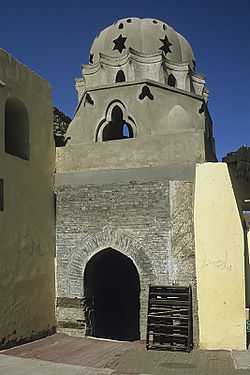
Fatimid tomb at the north-east of the 'Amri mosque at Qus | |
 Qus Location in Egypt | |
| Coordinates: 25°56′N 32°46′E / 25.933°N 32.767°E | |
| Country |
|
| Governorate | Qena Governorate |
| Time zone | EST (UTC+2) |
| • Summer (DST) | +3 (UTC) |
Qus (Arabic: قوص, derived from Ancient Egyptian Gesa or Gesy) is a city in the modern Qena Governorate, Egypt, located on the east bank of the Nile. Its modern name is one of many borrowings in Egyptian Arabic from Coptic, the last living phase of Ancient Egyptian. In Graeco-Roman times, it was called Apollonopolis Parva or Apollinopolis Mikra (Greek: Ἀπόλλωνος ἡ μικρά;[1] Ἀπόλλων μικρός),[2] or Apollonos minoris.[3]
During the Roman Empire it was renamed Diocletianopolis; and it corresponds, probably, to the Maximianopolis of the later Empire.
Gesa was an important city in the early part of Egyptian history. Because at that time it served as the point of departure for expeditions to the Red Sea. The city gradually lost its importance, only to regain it in the 13th century with the opening of an alternate commercial route to the Red Sea. Since then, Qus replaced Qift as the primary commercial center for trading with Africa, India, and Arabia. It thus became the second most important Islamic city in medieval Egypt, after Cairo.
Nowadays, only two pylons of the Ptolemaic temple of Harwer (Horus the Elder) and Heqet remain.
Today, Qus is the site of a major American/German commercial project to convert the waste products of sugar cane refining (bagasse) into paper products.
The modern population of Qus is around 300,000.
Coordinates: 25°56′N 32°46′E / 25.933°N 32.767°E
References
| Wikimedia Commons has media related to Qus. |
 This article incorporates text from a publication now in the public domain: Smith, William, ed. (1854–1857). "Apollinopolis". Dictionary of Greek and Roman Geography. London: John Murray. p. 160.
