Qurghonteppa
| Qurghonteppa Қурғонтеппа | |
|---|---|
|
Qurghonteppa in 2010 | |
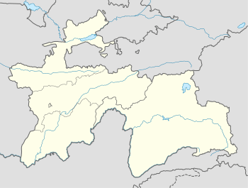 Qurghonteppa Location in Tajikistan | |
| Coordinates: 37°50′11″N 68°46′49″E / 37.83639°N 68.78028°ECoordinates: 37°50′11″N 68°46′49″E / 37.83639°N 68.78028°E | |
| Country |
|
| Province | Khatlon |
| Area | |
| • City | 26 km2 (10 sq mi) |
| Population (2014) | |
| • City | 101 600 |
| • Density | 3,907,6/km2 (101,210/sq mi) |
| • Metro | 175 000 |
| Area code(s) | 992-3222 |

Qurghonteppa or Kurganteppa (Tajik: Қурғонтеппа), formerly known as Kurgan-Tyube (Russian: Курган-Тюбе, Persian: قرغانتپه, Uzbek: Qo’rg’ontepa), is a city in southwestern Tajikistan. It is the capital of the Khatlon region and it is located 100 km from Dushanbe. It is estimated that the population of the city is close to 102,000 (est. 2014) people, making it the third-largest city in the country. The population fluctuates depending on season (due to Tajik immigrant workers in Russia). The political opposition in Tajikistan primarily comes from Qurghonteppa.[1]
Overview
Along with the capital Dushanbe, Qurghonteppa is demographically much more diverse than other major cities such as Khujand, Kulob or Istaravshan. Ethnicities include Tajiks, Uzbeks, Russians, Tatars, Ukrainians, Kazakhs, Greeks and many more. The city had a large number of ethnic Russians who were actively employed by the industrial and agricultural complexes in and around the city. Qurghonteppa was seriously demaged during the civil war in 1992-1997; during and after that war 85% of the Russians left the city.
Qurghonteppa International Airport serves a handful of cities in Tajikistan, Russia and Kazakhstan. The city is considered to be the heart of cotton ("white gold") cultivation in Tajikistan.
Qurghonteppa and Kulob are the main cities of south Tajikistan. Qurghonteppa is a regional hub (one of the top four), especially for banking and telecommunications industries.
Tajik immigrant workers (mostly employed in Russia) have significantly contributed to the local economy since early 2000s.
Climate
Qurghonteppa has a semi-arid climate (Köppen climate classification BSk), with cool winters and very hot summers. Precipitation is quite low, and peaks in spring, while summers are very dry.
| Climate data for Qurghonteppa | |||||||||||||
|---|---|---|---|---|---|---|---|---|---|---|---|---|---|
| Month | Jan | Feb | Mar | Apr | May | Jun | Jul | Aug | Sep | Oct | Nov | Dec | Year |
| Record high °C (°F) | 22.1 (71.8) |
27.9 (82.2) |
33.4 (92.1) |
36.7 (98.1) |
41.3 (106.3) |
43.6 (110.5) |
46.0 (114.8) |
42.8 (109) |
38.6 (101.5) |
36.1 (97) |
30.5 (86.9) |
24.3 (75.7) |
46 (114.8) |
| Average high °C (°F) | 8.1 (46.6) |
11.7 (53.1) |
17.2 (63) |
24.2 (75.6) |
30.4 (86.7) |
35.8 (96.4) |
37.3 (99.1) |
35.5 (95.9) |
31.2 (88.2) |
25.1 (77.2) |
17.6 (63.7) |
10.6 (51.1) |
23.73 (74.72) |
| Daily mean °C (°F) | 2.5 (36.5) |
5.4 (41.7) |
10.8 (51.4) |
17.2 (63) |
22.7 (72.9) |
27.3 (81.1) |
28.7 (83.7) |
26.4 (79.5) |
21.1 (70) |
15.2 (59.4) |
9.1 (48.4) |
4.4 (39.9) |
15.9 (60.62) |
| Average low °C (°F) | −1.5 (29.3) |
1.0 (33.8) |
5.9 (42.6) |
11.2 (52.2) |
15.3 (59.5) |
18.1 (64.6) |
19.3 (66.7) |
17.1 (62.8) |
12.1 (53.8) |
7.6 (45.7) |
3.2 (37.8) |
0.3 (32.5) |
9.13 (48.44) |
| Record low °C (°F) | −24.1 (−11.4) |
−22.6 (−8.7) |
−12.7 (9.1) |
−1.8 (28.8) |
4.0 (39.2) |
9.1 (48.4) |
11.0 (51.8) |
9.4 (48.9) |
3.5 (38.3) |
−4.2 (24.4) |
−10.9 (12.4) |
−20.0 (−4) |
−24.1 (−11.4) |
| Average precipitation mm (inches) | 36.1 (1.421) |
39.6 (1.559) |
61.0 (2.402) |
39.6 (1.559) |
24.1 (0.949) |
3.2 (0.126) |
0.3 (0.012) |
0.1 (0.004) |
0.8 (0.031) |
8.8 (0.346) |
19.3 (0.76) |
29.8 (1.173) |
262.7 (10.342) |
| Avg. precipitation days (≥ 0.1 mm) | 8.2 | 11.2 | 7.0 | 5.9 | 2.7 | 0.2 | 1.0 | 0.8 | 1.3 | 3.7 | 6.4 | 7.3 | 55.7 |
| Average relative humidity (%) | 73.2 | 70.1 | 62.3 | 57.6 | 50.2 | 45.5 | 45.6 | 48.3 | 51.0 | 57.1 | 66.6 | 73.0 | 58.38 |
| Mean monthly sunshine hours | 112 | 125 | 164 | 213 | 291 | 339 | 351 | 334 | 294 | 235 | 174 | 115 | 2,747 |
| Source #1: climatebase.ru[2] | |||||||||||||
| Source #2: NOAA (sun only, 1961-1990)[3] | |||||||||||||
Notable people
- Sergei Mandreko (1971-) - football coach
- Nurudin N. Mukhitdinov (1959-) - politician
References
- ↑ Ethnic groups at risk: The status of Tajiks Heritage Society
- ↑ "Kurgan-Tyube,Tajikistan". Climatebase.ru. Retrieved 31 January 2013.
- ↑ "Climate Normals for Kurgan-Tjube". National Oceanic and Atmospheric Administration. Retrieved 31 January 2013.
External links
| Wikimedia Commons has media related to Qurghonteppa. |
- Kurgan Tepe in Encyclopaedia Iranica Online
| ||||||||||||||||
