Qullpa Ananta
For the mountain on the border of the regions Cusco and Puno, Peru, see Chimpulla.
| Qullpa Ananta | |
|---|---|
 | |
| Elevation | 6,110 m (20,050 ft) |
| Location | |
 Qullpa Ananta Peru | |
| Location | Cusco Region, Peru |
| Range | Andes, Willkanuta |
| Coordinates | 13°43′53″S 71°09′36″W / 13.73139°S 71.16000°WCoordinates: 13°43′53″S 71°09′36″W / 13.73139°S 71.16000°W |
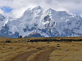
Qullpa Ananta (Aymara and Quechua qullpa saltpeter, hispanicized spellings Collpa Ananta, Colpa Ananta),[1][2] also known as Callangate, Cayangate, Ccallangate (hispanicized spellings) and Chimpulla (Chimboya), is a mountain in the Willkanuta mountain range of the Andes in Peru.[3] It lies in the Cusco Region, Quispicanchi Province, Ocongate District.[4][5] Qullpa Ananta is the second highest mountain in the Cusco Region, and ranks 24th highest in Peru.[6]
References
- ↑ Radio San Gabriel, "Instituto Radiofonico de Promoción Aymara" (IRPA) 1993, Republicado por Instituto de las Lenguas y Literaturas Andinas-Amazónicas (ILLLA-A) 2011, Transcripción del Vocabulario de la Lengua Aymara, P. Ludovico Bertonio 1612 (Spanish-Aymara-Aymara-Spanish dictionary)
- ↑ Teofilo Laime Ajacopa, Diccionario Bilingüe Iskay simipi yuyayk'ancha, La Paz, 2007 (Quechua-Spanish dictionary)
- ↑ John Biggar. "Andes Website - Information about Qullpa Ananta (Callangate)". Andes.org.uk. Retrieved 2013-01-14.
- ↑ escale.minedu.gob.pe - UGEL maps of the Quispicanchi Province 1 (Cusco Region)
- ↑ lib.utexas.edu Map of the area showing "Collpa Ananta"
- ↑ "Callangate - Cusco, Peru • peakery". Peakery.com. Retrieved 2013-01-14.