Quai de la Gare (Paris Métro)
Quai de la Gare | |||||||||||
|---|---|---|---|---|---|---|---|---|---|---|---|
| Paris Métro station | |||||||||||
 | |||||||||||
| Location |
13th arrondissement of Paris Île-de-France France | ||||||||||
| Coordinates | 48°50′13″N 2°22′22″E / 48.837069°N 2.372773°ECoordinates: 48°50′13″N 2°22′22″E / 48.837069°N 2.372773°E | ||||||||||
| Other information | |||||||||||
| Fare zone | 1 | ||||||||||
| History | |||||||||||
| Opened | 1 March 1909 | ||||||||||
| Services | |||||||||||
| |||||||||||
| Location | |||||||||||
 Quai de la Gare Location within Paris | |||||||||||
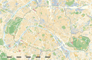
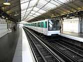
Quai de la Gare is a station of the Paris Métro serving line 6 at the intersection of the Quai de la Gare and the Boulevard Vincent Auriol in the 13th arrondissement.
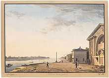
The station opened on 1 March 1909 with the opening of the original section of line 6 from Place d'Italie to Nation (although part of line 5—some dating back to 2 October 1900—was incorporated into line 6 on 12 October 1942). It is named after the Quai de la Gare on the south bank of the Seine, which was a wharf opened in 1770 and serving the Pitié-Salpêtrière Hospital. Nearby was the location of the Barrière de la Gare, a gate built for the collection of taxation as part of the Wall of the Farmers-General; the gate was built between 1784 and 1788 and demolished in 1819.
Nearby are the Ministry of Finance and Palais omnisports de Paris-Bercy.
Station layout
| Platform level | ||
| Westbound | ← | |
| Eastbound | | |
| 1F | Mezzanine for platform connection |
| Street Level |
Gallery
| Wikimedia Commons has media related to Quai de la Gare (Paris Metro). |
References
- Roland, Gérard (2003). Stations de métro. D’Abbesses à Wagram. Éditions Bonneton.