Qixing Mountain (Taipei)
Coordinates: 25°10′17″N 121°33′06″E / 25.17139°N 121.55167°E
| Qixing Mountain | |
|---|---|
 | |
| Elevation | 1,120 m (3,670 ft) |
| Prominence | 1,120 m (3,670 ft) |
| Location | |
| Location |
Beitou District, Taipei, |
| Coordinates | 25°10′17″N 121°33′06″E / 25.17139°N 121.55167°E |
| Geology | |
| Type | Dormant volcano |
| Age of rock | Pleistocene |
| Last eruption | 700,000 BC |
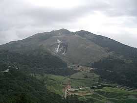
Qixing Mountain, also spelled Qixingshan or Chihsing Mountain, (Chinese: 七星山; Hanyu Pinyin: Qīxīng Shān; Tongyong Pinyin: Cising Shan; Wade–Giles: Chi1-Hsing1 Shan1; literally: "Seven Star Mountain") is located on the Datun Volcano Group and is the highest mountain in Taipei, at the rim of Taipei Basin. It is also the highest (dormant) volcano in Taiwan. It located in the center of Yangmingshan National Park and its main peak is 1,120 metres (3,675 ft) above sea level.
It began erupting about 700,000 years ago.[1] There was a crater at the peak but it became seven small peaks due to post-eruption erosion.
The mountain has faults running across the southeast and northwest contours with volcanic landforms like hot springs and fumaroles.
Shamaoshan (紗帽山) is a round volcanic dome looking like a black gauze cap. As the lava was more viscous when the mountain was formed, it gradually became a tholoid, also known as a cumulo-dome volcano, it's 643 metres (2,110 ft) above sea level. Shamaoshan and Qigushan (七股山, 890 metres (2,920 ft)) are parasitic volcanoes of Qixingshan.
This mountain is the source of the name for Shichisei District (七星郡), Taihoku Prefecture, Taiwan under Japanese rule.[2] This district included modern day Xizhi, Shilin, Beitou, Nangang, Neihu, Songshan, and Xinyi.