Qaras
| Qaras | |
|---|---|
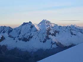 Aguja III (on the left), Qaras I (center-left), Pukarahu (in the background, center, the highest peak) and Qaras II (in the background, center, exactly in front of Pukarahu, hiding most of it) as seen from the southeast | |
| Elevation | 6,025 m (19,767 ft)[1] |
| Location | |
 Qaras Peru | |
| Location | Peru, Ancash Region |
| Range | Andes, Cordillera Blanca |
| Coordinates | 8°58′04″S 77°40′08″W / 8.96778°S 77.66889°WCoordinates: 8°58′04″S 77°40′08″W / 8.96778°S 77.66889°W |
| Climbing | |
| First ascent |
Qaras I: 1-1955 via S.E. glacier, E. slopes: Variant N.E. ridge & snow slopes to top-1971: Rock face to Caràs I/II col, N.E. ridge-1971: S. face-1979: S. face direct-1981: S.E. face-1981. Qaras II: 1-1955 via S.E. ridge, descend S. ice face: N. face-1977: S.E. face to E. ridge-1986. Qaras III: 1-1971 via N. side, S.W. ridge.[2] |
Qaras (Quechua, hispanicized spellings Carás, Caraz) is a mountain in the Cordillera Blanca in the Andes of Peru, about 6,025 metres (19,767 ft) high. It is situated in the Ancash Region, Huaylas Province, in the districts Caraz and Santa Cruz District. Qaras lies in the Huascarán National Park, southwest of the Artesonraju, northwest of the Pirámide, north of the Parun Lake and south of the little river Yuraqmayu of the Santa Cruz gorge.[3]
See also
References
- ↑ John F. Ricker, Yuraq Janka: Guide to the Peruvian Andes - Cordilleras Blanca & Rosko, Mountaineers Books, 1977
- ↑ Jill Neate, Mountaineering in the Andes, RGS-IBG Expedition Advisory Centre, 2nd edition, May 1994
- ↑ www.andix.com Map of a part of the Cordillera Blanca
External links
| Wikimedia Commons has media related to Cordillera Blanca. |