Qalqilya
| Qalqilya | ||
|---|---|---|
| Other transcription(s) | ||
| • Arabic | قلقيلية | |
|
View of Qalqilya | ||
| ||
 Qalqilya Location of Qalqilya within Palestine | ||
| Coordinates: 32°11′25.36″N 34°58′06.63″E / 32.1903778°N 34.9685083°ECoordinates: 32°11′25.36″N 34°58′06.63″E / 32.1903778°N 34.9685083°E | ||
| Palestine grid | 146/177 | |
| Governorate | Qalqilya | |
| Government | ||
| • Type | City | |
| • Head of Municipality | Othman Dawoud | |
| Area | ||
| • Jurisdiction | 25,637 dunams (25.6 km2 or 9.9 sq mi) | |
| Population (2007)[1] | ||
| • Jurisdiction | 91,217 | |
| Name meaning | "a type of pomegranate", or "gurgling of water"[2] | |
| Website | www.qalqiliamun.ps | |

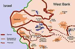
Qalqilya (Arabic: قلقيلية Qalqīlyaḧ); is a Palestinian city in the West Bank. Qalqilyah serves as the administrative centre for the Qalqilya Governorate. In the official 2007 census it had a population of 91,217.[1] Qalqilya is surrounded by the Israeli West Bank barrier with a narrow gap in the east controlled by the Israeli military and a tunnel to Hableh.[3][4]
History

The region has been populated since prehistoric times, as attested to by the discovery of prehistoric flint tools.
Ottoman era
In 1596, Qalqili appeared in Ottoman tax registers as a village in the Nahiya of Bani Sa'b in the Liwa of Nablus. It had a population of 13 Muslim households and paid taxes on wheat, barley, summercrops, olives, and goats or beehives.[5]
In 1882, Qalqilya was described as "A large somewhat straggling village, with cisterns to the north and a pool on the south-west. The houses are badly built."[6]
Qalqilya became an independent local council in 1909.
British Mandate period
In the 1922 census of Palestine conducted by the British Mandate authorities, Qalqileh had a population of 2803, 2,794 Muslims and 9 Christians,[7] increasing in the 1931 census to 3867, 3855 Muslims and 12 Christians, in a total of 796 houses.[8]
In 1945, Qalqilya was recognized as a municipal council.
In 1945 the population of Qalqilya was 5,850, all Arabs, who owned 27,915 dunams of land according to an official land and population survey.[9] Of this, 3701 dunams were for citrus and bananas, 3,232 were plantations and irrigable land, 16,197 used for cereals,[10] while 273 dunams were built-up (urban) land.[11]
1948–67
In the wake of the 1948 Arab–Israeli War, and after the 1949 Armistice Agreements, Qalqilya came under Jordanian rule.
In 1948, refugees from the Arab villages of Kafr Saba and Abu Kishek settled in Qalqilya and received assistance from UNRWA.
On the night of 10 October 1956 the Israeli army launched a raid against Qalqilya police station. The attack was ordered by Moshe Dayan and involved several thousand soldiers. During the fighting a paratroop company was surrounded by Jordanian troops and the survivors only escaped under close air-cover from four Israeli Air Force aircraft. 18 Israelis and between 70 and 90 Jordanians were killed in the operation.[12]
1967–present
After the Six-Day War in 1967, Qalqilya has been under Israeli occupation.
After the conquest of Qalqilya in 1967, dozens of its inhabitants were evicted by Israel to Jordan, and at least 850 buildings were razed.[13] In his memoirs, Moshe Dayan described the destruction as a "punishment" that was designed to chase the inhabitants away.[14] The villagers were eventually allowed to return and the reconstruction of damaged houses was financed by the military authorities.[15] In September 1967, a census found 8,922 persons, of whom 1,837 were originally from Israeli territory.[16]
In 2003, the Israeli West Bank barrier was built, encircling the town and separating it from agricultural lands on the other side of the wall.[17]
Local government
After the Oslo Accords, administration of Qalqilya was transferred to the Palestinian Authority. Hamas won the 2006 elections in the Qalqilya Governorate and Mayor Wajih Qawas was replaced by a member of Hamas. Qawas sees himself as a victim of a feud between the Islamist movement and Fatah.[18] Human rights groups have criticized both the PA and Hamas for their detentions without trial, dismissals of officials and closure of institutions and charities. In October 2012, after the second local government elections, Othman Dawoud became the new mayor.[18]
Economy
Between 1967–95 almost 80 percent of Qalqilya's labor force worked for Israeli companies or industries in the construction and agriculture sectors. The other 20% engaged in trade and commerce, marketing across the Green Line. Many of the inhabitants are farmers.
Qalqilya Zoo, established in 1986, is the largest zoo in the West Bank and the city's major employer. It houses 170 animals and works closely with zoologists from the Jerusalem Biblical Zoo and the Ramat Gan Safari.[19]
Notable residents
- Abu Ali Iyad – Fatah field commander in Jordan and Syria
- Walid Husayin
References
- ↑ 1.0 1.1 "Population, Housing and Establishment Census 2007 : Census Final Results in The West Bank Summary (Population and Housing)." (PDF). Palestinian Central Bureau of Statistics. 2008. Retrieved 2010-06-16.
- ↑ Palmer, 1881, p. 183
- ↑ Dani Filc and Hadas Ziv (2006). "Exception as the Norm and the Fiction of Sovereignty: The Lack of the Right to Health Care in the Occupied Territories". In John Parry. Evil, Law and the State: Perspectives on State Power and Violence. Editions Rodopi B.V. p. 75. ISBN 9789042017481.
- ↑ United Nations Office for the Coordination of Humanitarian Affairs Qalqiliya Closures map for December 2011
- ↑ Hütteroth and Abdulfattah, 1977, p. 140
- ↑ Conder and Kitchener, 1882, SWP II, p. 165
- ↑ Barron, 1923, Table IX, Sub-district of Tulkarem, p. 27
- ↑ Mills, 1932, p. 56
- ↑ Government of Palestine, Department of Statistics. Village Statistics, April, 1945. Quoted in Hadawi, 1970, p. 76
- ↑ Government of Palestine, Department of Statistics. Village Statistics, April, 1945. Quoted in Hadawi, 1970, p. 127
- ↑ Government of Palestine, Department of Statistics. Village Statistics, April, 1945. Quoted in Hadawi, 1970, p. 177
- ↑ Morris, 1993, pp. 397–399
- ↑ Masalha, 2007, 1967: Why Did the Palestinians Leave?
- ↑ Morris 2001, p. 328
- ↑ Elon 1983, pp. 231–232
- ↑ Joel Perlmann. The 1967 Census of the West Bank and Gaza Strip: A Digitized Version. Annandale-on-Hudson, N.Y.: Levy Economics. Institute of Bard College. November 2011 – February 2012. [Digitized from: Israel Central Bureau of Statistics, Census of Population and Housing, 1967 Conducted in the Areas Administered by the IDF, Vols. 1–5 (1967–70), and Census of Population and Housing: East Jerusalem, Parts 1 and 2 (1968–70). http://www.levyinstitute.org/palestinian-census/.] Vol. 1, Table 2.
- ↑ The Wall (Qalqilya) 2003 Relief Web, Retrieved 10th Dec 2009
- ↑ 18.0 18.1 Sharp, Heather (October 16, 2009). "Political struggle over West Bank town".
- ↑ Splish, splash, new Kalkiya's hippo's takin' a bath, Haaretz
Bibliography
| Wikimedia Commons has media related to Qalqilyah. |
- Barron, J. B., ed. (1923). Palestine: Report and General Abstracts of the Census of 1922 (PDF). Government of Palestine.
- Conder, Claude Reignier; Kitchener, H. H. (1882). The Survey of Western Palestine: Memoirs of the Topography, Orography, Hydrography, and Archaeology 2. London: Committee of the Palestine Exploration Fund.
- Elon, Amos (1983). The Israelis: founders and sons. Penguin Books. ISBN 978-0-14-016969-0.
- Guérin, Victor (1875). Description Géographique Historique et Archéologique de la Palestine (in French). 2: Samarie, pt. 2. Paris: L'Imprimerie Nationale. (pp. 356-7)
- Hadawi, Sami (1970). Village Statistics of 1945: A Classification of Land and Area ownership in Palestine. Palestine Liberation Organization Research Center.
- Hütteroth, Wolf-Dieter; Abdulfattah, Kamal (1977). Historical Geography of Palestine, Transjordan and Southern Syria in the Late 16th Century. Erlanger Geographische Arbeiten, Sonderband 5. Erlangen, Germany: Vorstand der Fränkischen Geographischen Gesellschaft. ISBN 3-920405-41-2.
- Mills, E., ed. (1932). Census of Palestine 1931. Population of Villages, Towns and Administrative Areas (PDF). Jerusalem: Government of Palestine.
- Morris, Benny (1993). Israel's Border Wars, 1949 – 1956. Arab Infiltration, Israeli Retaliation, and the Countdown to the Suez War. Oxford University Press. ISBN 0-19-827850-0.
- Morris, Benny (2001). Righteous victims: a history of the Zionist-Arab conflict, 1881-2001. Vintage Books. ISBN 978-0-679-74475-7.
- Palmer, E. H. (1881). The Survey of Western Palestine: Arabic and English Name Lists Collected During the Survey by Lieutenants Conder and Kitchener, R. E. Transliterated and Explained by E.H. Palmer. Committee of the Palestine Exploration Fund.
External links
- Welcome To The City of Qalqiliya
- Survey of Western Palestine, Map 11: IAA, Wikimedia commons
- UNRWA Profile: Qalqilya Town Update 2004 at the Wayback Machine (archived April 14, 2008)
| ||||||||||||||||

| ||||||||||||||||||