Qal'eh Hasan Ali
| Qal'eh Hasan Ali | |
|---|---|
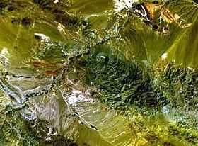 NASA Landsat image (with north to the top). | |
| Location | |
 Qal'eh Hasan Ali | |
| Coordinates | 29°40′N 57°57′E / 29.667°N 57.950°ECoordinates: 29°40′N 57°57′E / 29.667°N 57.950°E |
| Geology | |
| Type | Maars |
| Last eruption | Unknown |
Qal'eh Hasan Ali is a maar-producing volcanic field located southeast of Kerman Province, Iran. The field is presumed of Holocene age, though it has produced no historic eruptions. Consisting of 14 maars each of different size, its most major caldera is Great Crater, about 1.2 kilometres (0.75 mi) in width and 200–300 kilometres (120–190 mi) in depth.
Geologic history
The maars of Ali were produced from desert alluvium, granodioritic rocks, and Eocene activity. The group of maars was created separately from the remainder of Iran's stratovolcanoes. All have generated pyroclastic volcanic ash deposits, though none have actually erupted.[1]
See also
References
- ↑ "Qal'eh Hasan Ali". Global Volcanism Program. Retrieved April 11, 2009.