Pythio
| Pythio Πύθιο | |
|---|---|
|
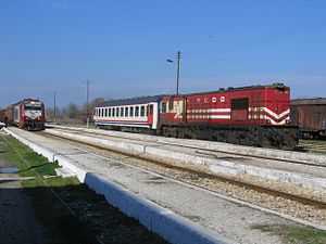
Pythio railway station | |
 Pythio | |
|
Location within the region | |
| Coordinates: 41°22.85′N 26°36.64′E / 41.38083°N 26.61067°ECoordinates: 41°22.85′N 26°36.64′E / 41.38083°N 26.61067°E | |
| Country | Greece |
| Administrative region | East Macedonia and Thrace |
| Regional unit | Evros |
| Municipality | Didymoteicho |
| Municipal unit | Didymoteicho |
| Lowest elevation | 55 m (180 ft) |
| Time zone | EET (UTC+2) |
| • Summer (DST) | EEST (UTC+3) |
| Postal code | 683 00 |
| Area code(s) | 25520 |
Pythio (Greek: Πύθιο, Bulgarian: Кулели Бургас, Turkish:Kuleliburgaz) is a village in the eastern part of Didymoteicho municipality, Evros regional unit, Greece. It is 16 km east of the centre of Didymoteicho, on the right bank of the river Evros, where it forms the border with Turkey. There is no border crossing near Pythio. Pythio is a railway junction where the railway to Ormenio and Bulgaria branches off the main line from Thessaloniki to Istanbul through Alexandroupoli and Uzunköprü. Pythio was known as Kuleliburgaz during Ottoman rule.[1] Railway reached Pythio in 1871 and a 112 km extension to Dedeağaç was opened in 1874. The railway was built by the Chemins de fer Orientaux (CO), managed by Maurice de Hirsch.
The community of Pythio consists of the villages Pythio, Rigio and Stathmos Pythiou (Pythio railway station). The nearest villages are Petrades to the south and Asimenio to the northwest.
Historical population
| Year | Town population | Municipal district population |
|---|---|---|
| 1981 | 1,186 | - |
| 1991 | 734 | 951 |
| 2001 | 556 | 747 |
Sites of interest
- Castle of Pythion, built in the 14th century
See also
References
External links
| ||||||||||
