Pyramid Mountain (Clallam County, Washington)
| Pyramid Mountain | |
|---|---|
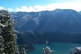
 Pyramid Peak summit view in February with Mount Baker in the distance. | |
| Elevation | 3100+ ft (945+ m) NGVD 29[1] |
| Prominence | 700 ft (210 m)[1] |
| Location | |
| Location | Clallam County, Washington, U.S. |
| Range | Olympic Mountains |
| Coordinates | 48°04′29″N 123°48′25″W / 48.0748092°N 123.806866°WCoordinates: 48°04′29″N 123°48′25″W / 48.0748092°N 123.806866°W[2] |
Pyramid Mountain is located high above Lake Crescent's north shore.[3] Once known as Sugarloaf Mountain, it received its present name in 1928.[4] It contains the ruins of an old fire lookout at the summit. It dominates the view from Barnes Point and Lake Crescent Lodge. It is accessible by trail from the Spruce Railroad Trail. On a clear day, Mount Baker is visible in the Cascade Range across the Puget Sound.
From the summit, it is easy to see the landslide that blocked Indian Creek and dammed Lake Crescent. Below the landslide is Lake Sutherland and the Indian Creek valley down to the Elwha River.
References
- ↑ 1.0 1.1 "Pyramid Mountain, Washington". Peakbagger.com.
- ↑ "Pyramid Mountain". Geographic Names Information System. United States Geological Survey.
- ↑ Sykes, Karen (March 21, 2002), "Hike of the Week: Eye-popping scenery in the Olympics", The Seattle Post-Intelligencer
- ↑ Majors, Harry M. (1975). Exploring Washington. Van Winkle Publishing Co. p. 15. ISBN 978-0-918664-00-6.
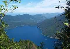 View of the landslide that dammed Lake Crescent |
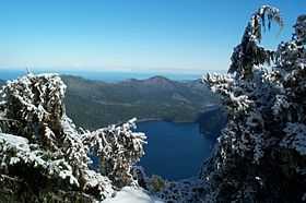
 Aurora Ridge across Lake Crescent in Feb |