Punta, Calamba
| Barangay Punta, Calamba City Barangay ng Punta, Lungsod ng Calamba | |
|---|---|
| Barangay | |
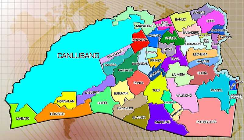
 Map of Calamba City showing the location of the barangays | |
| Coordinates: 14°10′40″N 121°7′14″E / 14.17778°N 121.12056°ECoordinates: 14°10′40″N 121°7′14″E / 14.17778°N 121.12056°E | |
| Country | Philippines |
| Province | Laguna |
| Region | CALABARZON (Region IV-A) |
| City | Calamba City |
| Number of Puroks | 6 |
| Government | |
| • Chairman | Roman Lalap |
| • Councilors |
{{plainlis
|
| • SK chairman | Ma. Fenadee Encinas |
| • SK Councilors |
|
| Area | |
| • Land | 3.31 km2 (1.28 sq mi) |
| Population (projection based on 2007 NSO Growth Rate) | |
| • Total | 2,898 |
| • Density | 875.53/km2 (2,267.6/sq mi) |
| Time zone | PST (UTC+8) |
| • Summer (DST) | not observed (UTC+8) |
| Area code(s) | 49 |
Punta is a rural barangay of Calamba City, Laguna in the Philippines. It is situated in the central-south portion of the city.
Geography
Punta lies in the central-southern part of Calamba City. The barangay is bordered by: Kay-Anlog in the south; Bubuyan in the west; Tulo in the east, PaloAlto in the north-west and Barandal in the north. It has a total area of 331 hectares.[1]
Demography
According to 2007 Census, Punta has a population of 2,615, one of least-populated barangays in Calamba
| Year | Population |
|---|---|
| 2007 | 2,615 |
| 2000 | 1,555 |
| 1995 | 1,214 |
| 1990 | 1,108 |
| 1980 | 986 |
References
| ||||||||||||||||||||||||||||||||||||||||||||||||