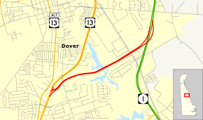
Puncheon Run Connector
| Puncheon Run Connector | |
|---|---|
|
Puncheon Run Connector highlighted in red | |
| Route information | |
| Maintained by DelDOT | |
| Length: | 2.39 mi[1] (3.85 km) |
| Existed: | 2000 – present |
| Major junctions | |
| West end: |
|
| East end: |
|
| Location | |
| Counties: | Kent |
| Highway system | |
| Routes in Delaware | |
The Puncheon Run Connector is an unnumbered four-lane freeway in Dover, Delaware. It is named after Puncheon Run, a stream it follows. It provides a connection between U.S. Route 13 (US 13) and the northbound direction of the Delaware Route 1 (DE 1) toll road, with an intermediate interchange at Bay Road. The road is part of the National Highway System and serves as part of a north-south route for traffic crossing the Delmarva Peninsula. Planning for the Puncheon Run Connector began in the 1980s and originally included a freeway upgrade for US 13 south to Woodside. The connector was scaled back to its current routing in 1992. The freeway was built between 1998 and 2000 at a cost of $25 million.
Route description

The Puncheon Run Connector begins at an at-grade intersection with US 13 in Dover, heading to the northeast as a four-lane freeway. After passing over State Street, the freeway curves to the east and passes between woods to the south and residential and commercial development to the north. The road crosses over the marshy St. Jones River and continues east-northeast, passing between a residential neighborhood to the south and the Delaware Department of Transportation (DelDOT) headquarters to the north before coming to an eastbound exit and westbound entrance at Bay Road. Immediately after the Bay Road interchange, the Puncheon Run Connector merges into northbound DE 1 a short distance to the north of Dover Air Force Base.[2][3]
The Puncheon Run Connector has an annual average daily traffic count of 13,406 vehicles.[1] The entire length of the Puncheon Run Connector is part of the National Highway System.[4]
History
Planning for the Puncheon Run Connector dates back to the 1980s, when a "Relief Route" was proposed for US 13 between Dover and Wilmington. In 1987, plans called for the Puncheon Run Connector to be built along its current alignment between US 13 and DE 1, with an intermediate interchange at US 113 (Bay Road), in addition to US 13 being upgraded to a freeway south to Woodside, with interchanges at Webbs Lane in Dover and DE 10 in Camden.[5] In 1992, DelDOT held a meeting to discuss proposals for the road, including a possible Far West By-Pass Connector through the western part of Dover. The city of Dover initially opposed the Puncheon Run Connector and favored the Far West By-Pass Connector as the latter would ease traffic congestion caused by development in the western part of the city.[6] Plans for the connector were modified in 1992 to not include the upgrade of US 13 to a freeway between Woodside and Dover.[5] Prior to the construction of the Puncheon Run Connector, a site along Puncheon Run had to be excavated by DelDOT and Louis Berger & Associates as it consisted of Native American artifacts from prehistoric times.[7] The excavation of the site lasted from October 1997 to September 1998.[8] Construction on the road began in October 1998.[9] The Puncheon Run Connector was completed and opened to traffic in a ribbon cutting ceremony on December 19, 2000.[10] The road was constructed by David A. Bramble, Inc. and G.A. & F.C. Wagman, Inc. at a cost of $25 million.[11]
Exit list
The entire route is in Kent County.
| Location | mi[1] | km | Exit | Destinations | Notes |
|---|---|---|---|---|---|
| Dover | 0.00 | 0.00 | At-grade intersection, no access from southbound US 13 | ||
| Dover Air Force Base | 1.61 | 2.59 | 2A | Bay Road south – Dover Air Force Base | Eastbound exit and westbound entrance |
| 1.61 | 2.59 | 2B | Bay Road north – South Dover | Eastbound exit and westbound entrance | |
| 2.39 | 3.85 | Access to north DE 1, access from south DE 1 | |||
| 1.000 mi = 1.609 km; 1.000 km = 0.621 mi | |||||
See also
- U.S. Roads portal
- Delaware portal
References
- ↑ 1.0 1.1 1.2 Staff (2011). "Traffic Count and Mileage Report: Kent County" (PDF). Delaware Department of Transportation. Retrieved July 18, 2012.
- ↑ Delaware Department of Transportation (2008). Delaware Official Transportation Map (PDF) (Map) (2008 ed.). Dover: Delaware Department of Transportation. Retrieved March 22, 2012.
- ↑ Google (March 17, 2010). "overview of Puncheon Run Connector" (Map). Google Maps. Google. Retrieved March 17, 2010.
- ↑ National Highway System: Delaware (PDF) (Map). Federal Highway Administration. 2010. Retrieved February 10, 2012.
- ↑ 5.0 5.1 "Puncheon Run Alternative Selected" (PDF). On the Road (10) (Delaware Department of Transportation). Summer 1992. p. 1. Retrieved October 18, 2014.
- ↑ "Regular Council Meeting". City of Dover. August 10, 1992. Retrieved July 18, 2012.
- ↑ "Explore Delaware’s Prehistory at Puncheon Run" (PDF). Delaware Department of Transportation. Retrieved August 18, 2010.
- ↑ "Section 1.0 Introduction" (PDF). Delaware Department of Transportation. 2005. Retrieved August 18, 2010.
- ↑ "Council Committees". City of Dover. October 12, 1998. Retrieved July 18, 2012.
- ↑ "SR 1 in Home Stretch" (PDF). On the Road (26) (Delaware Department of Transportation). Spring 2001. p. 2. Retrieved October 18, 2014.
- ↑ "The History of David A. Bramble, Inc". David A. Bramble, Inc. Retrieved March 27, 2009.
External links
Route map: Bing
 Media related to Puncheon Run Connector at Wikimedia Commons
