Pumapampa
| Pumapampa | |
|---|---|
| Ratakinwa | |
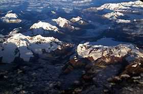 Aerial view of the Cordillera Blanca as seen from the south-east with Perlilla (bottom right) and Pumapampa (above it) | |
| Elevation | 5,300 m (17,400 ft)[1] |
| Location | |
 Pumapampa Peru | |
| Location | Peru, Ancash Region |
| Range | Andes, Cordillera Blanca |
| Coordinates | 9°17′33″S 77°22′16″W / 9.29250°S 77.37111°WCoordinates: 9°17′33″S 77°22′16″W / 9.29250°S 77.37111°W |
Pumapampa (Quechua puma cougar, puma, pampa a large plain,[2] "cougar plain", hispanicized spelling Pomabamba) or Ratakinwa (Rataquenua)[3] is a mountain in the Cordillera Blanca in the Andes of Peru, about 5,300 metres (17,388 ft) high. It is situated in the Ancash Region, Asunción Province, Chacas District, and in the Carhuaz Province, Marcará District. Pumapampa lies between Qupa in the west and Perlilla in the east, southwest of the lakes Yanaqucha, Paqarisha (Pagarisha) and Lawriqucha.[1]
References
- ↑ 1.0 1.1 escale.minedu.gob.pe - UGEL map of the Asunción Province (Ancash Region)
- ↑ Teofilo Laime Ajacopa, Diccionario Bilingüe Iskay simipi yuyayk'ancha, La Paz, 2007 (Quechua-Spanish dictionary)
- ↑ huaraz.com Map of the area