Pukasaya (Moquegua)
For the mountain in the Arequipa Region, Peru, see Pukasaya (Arequipa).
| Pukasaya | |
|---|---|
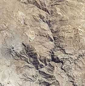 Satellite image of the volcano Ubinas (on the left) and Pukasaya (lower left) | |
| Elevation | 5,320 m (17,450 ft)[1] |
| Location | |
 Pukasaya Peru | |
| Location | Peru, Moquegua Region, General Sanchez Cerro Province |
| Range | Andes |
| Coordinates | 16°27′33″S 70°56′10″W / 16.45917°S 70.93611°WCoordinates: 16°27′33″S 70°56′10″W / 16.45917°S 70.93611°W |
Pukasaya (Quechua puka red, saya slope,[2] "red slope", hispanicized Pucasaya) is a 5,320 metres (17,454 ft) high mountain in the Andes of Peru. It is situated south-east of the salt lake Salinas. The mountain is located in the Moquegua Region, General Sánchez Cerro Province, Matalaque District, south-west of the active volcano Ubinas.[3] Pukasaya lies on the southern border of the buffer zone of the Salinas and Aguada Blanca National Reservation.[1]
See also
References
- ↑ 1.0 1.1 Valoración del Servicio Ambiental de Provisión de Agua con Base en la Reserva Nacional Salinas y Aguada Blanca - Cuenca del Río Chili, PROFONANPE, Lima, 2007
- ↑ Teofilo Laime Ajacopa, Diccionario Bilingüe Iskay simipi yuyayk'ancha, La Paz, 2007 (Quechua-Spanish dictionary)
- ↑ escale.minedu.gob.pe - UGEL map of the General Sánchez Cerro (Moquegua Region)