Pukaranra
For the mountain in the Arequipa Region, Peru, see Pukaranra (Arequipa).
| Pukaranra | |
|---|---|
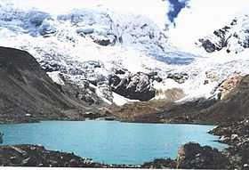
 Pallqarahu (on the left) and Pukaranra (on the right) behind the lake Pallqaqucha | |
| Elevation | 6,147 m (20,167 ft) |
| Location | |
 Pukaranra Peru | |
| Location | Peru, Ancash Region |
| Range | Andes, Cordillera Blanca |
| Coordinates | 9°23′30″S 77°21′03″W / 9.39167°S 77.35083°WCoordinates: 9°23′30″S 77°21′03″W / 9.39167°S 77.35083°W |
| Climbing | |
| First ascent |
1948 via S.W. spur of S. ridge?: Variant on S.W. side-1954: E. slopes-1957: N.E. ridge-1959: S.W. ridge, S.W. face-1965: W. ridge-1977[1] |
| Easiest route | southeast ridge, AD |
Pukaranra (Quechua puka red, ranra stony / stony ground,[2][3] hispanicized spelling Pucaranra) is a mountain in the Cordillera Blanca in the Andes of Peru,[4] about 6,147 m (20,167 ft) high. It is situated in the Ancash Region south-west of the mountain Rurichinchay (Chinchey).
Climbing
Several interesting lines on this mountain, none of them very serious but all requiring commitment. The east-northeast risge is rated AD/D (depending on conditions), the southeast face AD+ and the southeast ridge AD.
References
- ↑ Jill Neate, Mountaineering in the Andes, 1994
- ↑ Teofilo Laime Ajacopa, Diccionario Bilingüe Iskay simipi yuyayk'ancha, La Paz, 2007 (Quechua-Spanish dictionary)
- ↑ Diccionario Quechua - Español - Quechua, Academía Mayor de la Lengua Quechua, Gobierno Regional Cusco, Cusco 2005 (Quechua-Spanish dictionary)
- ↑ www.andix.com Map of the Cordillera Blanca