Pukarahu (Ticapampa)
This article is about the mountain in the Ticapampa District, Recuay Province, Ancash Region, Peru. For other uses, see Pukarahu.
| Pukarahu | |
|---|---|
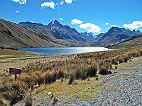 Qiruqucha and the mountain Pukarahu (center-left) | |
| Elevation | 5,346 m (17,539 ft) |
| Location | |
 Pukarahu Peru | |
| Location | Ancash, Peru |
| Range | Cordillera Blanca |
| Coordinates | 9°40′30″S 77°18′35″W / 9.67500°S 77.30972°WCoordinates: 9°40′30″S 77°18′35″W / 9.67500°S 77.30972°W |
| Climbing | |
| First ascent | 1-1967 via S.face: N.W. ridge-1973.[1] |
Pukarahu (Quechua puka red,[2] rahu snow, ice, mountain with snow,[3] "red snow covered mountain", hispanicized spelling Pucaraju) is a mountain in the Cordillera Blanca in the Andes of Peru, about 5,346 metres (17,539 ft) high. It is situated in the Ancash Region, Recuay Province, Ticapampa District.[4][5] Pukarahu lies west of Yanamaray and northeast of the lake named Qiruqucha.
Sources
- ↑ Jill Neate, Mountaineering in the Andes, RGS-IBG Expedition Advisory Centre, 2nd edition, May 1994: "Yanamarey Group: Pucaraju 5346m: 1-1967 via S.face: N.W. ridge-1973."
- ↑ Teofilo Laime Ajacopa, Diccionario Bilingüe Iskay simipi yuyayk'ancha, La Paz, 2007 (Quechua-Spanish dictionary)
- ↑ babylon.com
- ↑ escale.minedu.gob.pe - UGEL map of the Yungas Province (Ancash Region) showing the location of Pucarahu (unnamed) northeast of the mountain labelled "Cerro Pucaraju" and northeast of the lake Qiruqucha
- ↑ andix.com Map of a part of the Cordillera Blanca