Pukaqaqa Punta
For the mountain in the Lima Region, Peru, see Pukaqaqa. For the district in the San Martín Region, Peru, see Pucacaca District.
| Pukaqaqa Punta | |
|---|---|
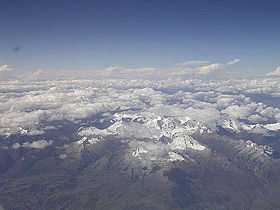
 Cordillera Blanca as seen from the west with Pukaqaqa Punta and Churup (lower-right) | |
| Elevation | 5,400 m (17,700 ft)[1] |
| Location | |
 Pukaqaqa Punta Peru | |
| Location | Peru, Ancash Region |
| Range | Andes, Cordillera Blanca |
| Coordinates | 9°27′20″S 77°24′14″W / 9.45556°S 77.40389°WCoordinates: 9°27′20″S 77°24′14″W / 9.45556°S 77.40389°W[2] |
Pukaqaqa Punta[1] or Pukaqaqa[3] (Quechua puka red, qaqa rock, "red rock", Ancash Quechua punta first, before, in front of,[4][5] Spanish punta tip, point, hispanicized spelling Pucagaga Punta, Pucagaga) is a mountain in the Cordillera Blanca in the Andes of Peru, about 5,400 metres (17,717 ft) high. It is situated in the Ancash Region, Huaraz Province, Independencia District, north-east of Huaraz.[1] Pukaqaqa Punta lies south of the mountain Ranrapallqa next to the mountain Churup, north-east of it.
References
- ↑ 1.0 1.1 1.2 escale.minedu.gob.pe - UGEL map of the Huaraz Province (Ancash Region) showing Nevado Pucagaga Punta
- ↑ "Nevados". IGN, Peru. Retrieved August 21, 2014.
- ↑ sys.sernanp.gob.pe:8080/.../Guía%20Huascarán.pdf SERNAP: Map of the Cordillera Blanca
- ↑ Teofilo Laime Ajacopa, Diccionario Bilingüe Iskay simipi yuyayk'ancha, La Paz, 2007 (Quechua-Spanish dictionary)
- ↑ homepage.ntlworld.com/robert_beer Robert Beér, Armando Muyolemaj, Dr. Hernán S. Aguilarpaj, Vocabulario comparativo, quechua ecuatoriano - quechua ancashino - castellano - English, Brighton 2006