Puerto Octay
| Puerto Octay | |||||
|---|---|---|---|---|---|
| Town and Commune | |||||
| |||||
| Coordinates (town): 40°58′S 72°54′W / 40.967°S 72.900°WCoordinates: 40°58′S 72°54′W / 40.967°S 72.900°W | |||||
| Country | Chile | ||||
| Region | Los Lagos | ||||
| Province | Osorno | ||||
| Founded | 22 December 1891 | ||||
| Government[1] | |||||
| • Type | Municipality | ||||
| • Alcalde | Carlos Mancilla Solís (DC) | ||||
| Area[2] | |||||
| • Total | 1,795.7 km2 (693.3 sq mi) | ||||
| Population (2002 Census)[2] | |||||
| • Total | 10,236 | ||||
| • Density | 5.7/km2 (15/sq mi) | ||||
| • Urban | 3,403 | ||||
| • Rural | 6,833 | ||||
| Sex[2] | |||||
| • Men | 5,391 | ||||
| • Women | 4,845 | ||||
| Time zone | CLT[3] (UTC-4) | ||||
| • Summer (DST) | CLST[4] (UTC-3) | ||||
| Area code(s) | 56 + | ||||
| Website | Municipality of Puerto Octay | ||||
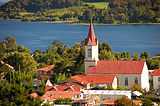
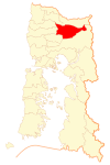
Puerto Octay is a town and commune located on the north shore of Llanquihue Lake in Los Lagos Region in the south of Chile. It was settled by German colonists in 1852. Puerto Octay was an important port with regular traffic to Puerto Varas before the coming of railway in 1912.
History
Its origin dates back to the German colonization in 1852 driven by Bernhard Philippi. With the passage of time becomes one of the major ports of Lake Llanquihue. On 22 December of 1891 is established as a municipality, under the Presidency of the Republic Jorge Montt.[5]
German heritage history

Puerto Octay currently has a rich and varied architecture, mostly built of wood, which is the historical reflection of the colonization process, driven by the State of Chile in the mid-nineteenth century, with families coming from Germany.
So constructions emerge as the House Niklitschek, Hotel Haase, Wulf House, current Colegio San Vicente de Paul and House Werner to name a few. What is extraordinary about this city is that despite the lapse of more than 100 years, it is still possible to assess this type of buildings.
As a way to cherish and protect this architectural heritage, now taking place in Puerto Octay a process of declaration of Typical Zone, where they will identify a representative area of identity and history, which will be legally protected by the State of Chile.
Flora and fauna

Birds: thrush, dove, parrot, rooster from the mountain (extinct), kestrel, heron, sparrows, swallows.
Mammals: cougar, nutria, among others.
Fish: salmon native (locally extinct), mackerel, trout.
Tourism

Referring to tourism in the district lake, Lake Llanquihue has beautiful beaches for vacation or go fishing and water sports beaches highlighting Falls, Rupanco Islet, La Baja, Puerto Maitén and Fonck.
Demographics
According to the 2002 census of the National Statistics Institute, Puerto Octay spans an area of 1,795.7 km2 (693 sq mi) and has 10,236 inhabitants (5,391 men and 4,845 women). Of these, 3,403 (33.2%) lived in urban areas and 6,833 (66.8%) in rural areas. The population fell by 7.4% (815 persons) between the 1992 and 2002 censuses.[2]
Administration
As a commune, Puerto Octay is a third-level administrative division of Chile administered by a municipal council, headed by an alcalde who is directly elected every four years.[1]
Within the electoral divisions of Chile, Puerto Octay is represented in the Chamber of Deputies by Mr. Fidel Espinoza (PS) and Mr. Carlos Recondo (UDI) as part of the 56th electoral district, (together with Puyehue, Río Negro, Purranque, Fresia, Frutillar, Llanquihue, Puerto Varas and Los Muermos). The commune is represented in the Senate by Camilo Escalona Medina (PS) and Carlos Kuschel Silva (RN) as part of the 17th senatorial constituency (Los Lagos Region).
References
- ↑ 1.0 1.1 "Municipality of Puerto Octay" (in Spanish). Retrieved 13 December 2010.
- ↑ 2.0 2.1 2.2 2.3 "National Statistics Institute" (in Spanish). Retrieved 13 December 2010.
- ↑ "Chile Time". WorldTimeZones.org. Retrieved 26 September 2010.
- ↑ "Chile Summer Time". WorldTimeZones.org. Retrieved 26 September 2010.
- ↑ (Spanish) Puerto Octay, Un Recodo Alemán
External links
- (Spanish) Municipality of Puerto Octay
- Hotel Haase
- Municipality of Puerto Octay
- Municipal Public Library Puerto Octay
- LagoLlanquihue.com Information Portal of the communities of the Lake
- Page of Puerto Octay
| ||||||||||||||||||||


