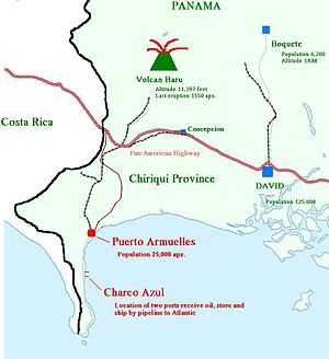
Puerto Armuelles, Chiriquí
| Puerto Armuelles Rabo De Puerco El Petrolero | |
|---|---|
| City | |
| Nickname(s): The petroleum capital of Panama | |
 Puerto Armuelles global positioning | |
| Country | Panama |
| Province | Chiriquí |
| Region | Pacific West Coast |
| Founded | 1928 |
| City Status | 1990 |
| Government | |
| • Type | Cosmopolitan borough, City |
| • Governing body | Puerto Armuelles City Council |
| Area | |
| • City | 200.40 km2 (77.37 sq mi) |
| Population (2005 est 24,900) | |
| • Density | 100/km2 (300/sq mi) |
| • Urban | 8,200 |
| • Ethnicity |
30% White 10% Asian 10% 10% Chinese 50% Mixed Race |
| Climate | Am |
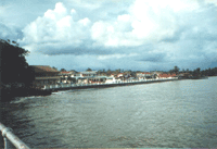
Puerto Armuelles is a city on Panama's Pacific Coast in the western province of Chiriquí Province next to Costa Rica. Puerto Armuelles is the second largest city in Chiriqui province with a population near 25,000, and has not one, but two different type of deep-water ports, one for bananas and one for oil.
Overview
Puerto Armuelles is just 5 miles (8.0 km) from the border with Costa Rica as the crow flies yet the actual border crossing lies 21 miles (34 km) away. David the capital of Chiriquí Province is about 60 miles (97 km) away. Panama City is some 235 miles (378 km) way, or approximately 6–8 hours drive on the Pan American Highway. Puerto Armuelles' most famous citizen is Omar Moreno, who was a baseball outfielder from 1975 to 1986 in the U.S. The name, Puerto Armuelles, was given to the city in honor of one of the heroes of the Coto war, Tomás Armuelles, member of the Panamanian Defense Forces (PDF) who died in an accident on March 18, 1921, during the Coto War between Panama and Costa Rica. The former name of the city was "Rabo de Puerco" or "Pigtail". Google earth has as of April 2008 updated images of Puerto Armuelles to a much clearer image. The image shows from the bridge entering town all the way down the coast past the oil port terminals. Although most of the image is empty ocean any clear picture of the main parts of Puerto Armuelles are a blessing.
Once the center of a thriving banana economy, Chiquita Banana i.e. United Fruit Company sold its unprofitable Pacific division, which was based in Puerto Armuelles since 1927, to a cooperative of banana workers in 2003. Striking workers and other such problems with employees sped the demise of Puerto Armuelles relationship with United Fruit Company.
Panama fought Costa Rica in the 1920s near Puerto Armuelles. The Coto War was fought over a relatively small piece of territory. Panama was victorious, but gave the territory to Costa Rica in the 1940s after the dispute was mediated by the U.S.A. and found in favor of Costa Rica. The President of Panama decided to abide by that ruling although it was a very unpopular decision in Panama. An interesting side note is that today Panama and Costa Rica both have no military, just a civil defense force. Both countries, although doing so decades apart, felt that this was the only way to end military takeovers of their governments. For more info see military of Panama.
Heavy industry and petroleum
Puerto Armuelles' other major employer is oil-related. In the 1970s in response to the oil embargo Alaska's Prudhoe Bay was developed and a pipeline built down to ports in the southern Alaska. Due to the size or lack of it the Panama Canal cannot handle supertankers and thus were unable to cross over to the Atlantic Ocean and to the refineries of Houston and the Gulf coast. Puerto Armuelles with its deep water just outside town called Charco Azul or in English "Blue Ditch" was an ideal place to bring in those Super Tankers and unload. Once switch to Panamax tankers the oil could then cross the canal and on to the U.S. refineries. Very soon after operations started the need for a pipeline was recognized and one built in 1982 crossing from Puerto Armuelles over the mountains with the help of pumping stations like that at Boquete and ending in Chiriqui Grande in Bocas del Toro province on the Caribbean coast,

where once again supertankers could take the oil on to U.S. refineries.
It seems oil will become Puerto Armuelles' salvation from economic ruin of losing its "company" the United Fruit Company. In 2006 it was announced that Puerto Armuelles was in the running to be considered for a refinery. Occidental (OXY) said by the end of 2007 or the beginning of 2008 they will finish their feasibility study regarding the possibility of building a petroleum refinery in Puerto Armuelles in the province of Chiriquí Province. The refinery, with a cost of about $7 billion dollars, will be able to process 400,000 barrels (64,000 m3) of heavy crude from Mexico, South America, and the Middle East. Much of the refinery's output will be delivered to the west coast of the United States, and will include 185,000 barrels (29,400 m3) of gasoline per day, 45,000 barrels (7,200 m3) of jet fuel, 90,300 barrels (14,360 m3) of diesel fuel and 6,300 daily barrels of fuel oil.
In 2009 due to the economic downturn globally the plans for a refinery were put on hold. So far it is known that OXY has held conversations with investors that might be interested in the project. Petroterminales of Panama (PTP) is also being negotiated with to obtain their participation. Panama's only other refinery in Colon closed in 2002. The deal is still pending, but this multi-billion dollar/euro deal will mean that the economic good times come back to Puerto Armuelles after the loss of the United Fruit Company banana business. The project would generate approximately 6,000 new direct and indirect jobs. Panama is programming courses to train new welders and electricians, among others to prepare for this economic boom. Construction may begin as early as February 2008. An interesting side note is that apparently Panama's willingness to become home of a new refinery in Puerto Armuelles has brought another unrelated oil group to Panama interested in building a new refinery in Colon which is located at the Atlantic side entrance to the Canal. The Canal expansion which is underway and Puerto Armuelles refinery projects were worth more than Panama's GDP combined a second refinery would bring that investment well above the GDP.
Earthquakes have hit Puerto Armuelles several time including one in July 1934 and another on Christmas night 2003 both of which killed several locals. On July 1, 1979 an earthquake hit Puerto Armuelles, which destroyed the poorly built multistory high school (fortunately it was a Sunday afternoon). The oil terminal also suffered extensive damage worth $2 million, including the loss of a very expensive part into the deep water of Charco Azul, and, although divers were contracted, the steep descent of the ocean floor led to the part rolling off and never being recovered.
Beyond the earthquakes which are common anywhere in the Pacific Rim of fire, Puerto Armuelles' weather is tropical weather for latitude 8.28333 degrees. Highs around 92 °F most days and lows around 72 °F at night. The beach is nearby if it is too hot for you or up the mountain to Volcan Baru, which towers over the area at 11,400 feet (3478 m) high, and can be seen from hills of Monte Verde. Puerto Armuelles currently is "a company town which lost its company" according to the weekly newsletter "So you want to retire to Panama" May 9, 2005 edition by Paradise Services. Also the mass migration of the young people to the big cities, particularly Panama City, has been on going for decades just like in the U.S. rural areas.
Recently, the economic future of Puerto Armuelles is looking much more hopeful. Government of President Ricardo Martinelli has allocated money to widen the road to Puerto Armuelles from a 2-lane into a 4-lane road. One of the key reasons for this road expansion project is to service a new deep container port outside of Puerto Armuelles. This future Puerto Armuelles’ port will have 217 storage facilities, a deepwater container, future cruise ship port, and a marina. These two construction projects will create what the Panama government is callings a 4 lane “dry canal” highway connecting Puerto Armulles to Chiriqui Grand on the Caribbean side of Panama. It is anticipated it will have a similar economic effect to the “wet canal” in Panama City.
In addition to these two construction projects, the Panamanian government has agreed to cancel the debt of Coosemupar and to compensate the workers. Puerto Armuelles has been in economic shackles for years because of the enormous debt owed by Coosemupar. Coosemupar is a worker cooperative that owns and operates the many banana plantations in the Puerto Armuelles area. Coosemupar, with government help, purchased the banana operations in Puerto Armuelles when Chiquita Banana left in 2003. Coosemupar is no longer functional. It has been trying to sell its operations for years, but no new banana company has wanted to start business saddled with Coosemupar's enormous debt.
In January 2012, President Martinelli and members of Coosemupar, signed an agreement that states that the government will: 1) Pay off Coosemupar’s 19.7 million dollar debt. The 24 banana plantations will then revert to Government ownership. 2) Give relief and land to the plantation workers who still live on the plantations. 3) Sell the 24 banana plantations (fincas) to companies that will provide the greatest number of jobs. The 2 soon-to-begin construction projects and the agreement to dissolve Coosemupar's debt indicate that the Panamanian government is now activity promoting the economic revitalization of Puerto Armuelles.
If you ever travel to Puerto Armuelles and drive in the best route to downtown is once past the main bridge entering town a half mile (.8 km) the road will fork, take the right fork (straight gets you lost). After a third of a mile (.55 km) the road turns slightly left and crosses what used to be a railroad track which was ripped out when Chiquita left town. Another third of a mile (.55 km) the road will make a turn left at the high school, turning 90 degrees left. Another third of a mile the road will make a slight left and cross a bridge approximately a half mile (.8 km) after the big left curve. Two tenths of a mile (.33 km) after the bridge you should see the local hospital on your left. The road will curve right after this and you will arrive at a semi-confusing intersection. At this point going straight another quarter mile (.4 km) gets you to the local airport and continuing on straight takes you to the "zonita" (small zone) named so because mostly Americans (working for Chiquita) lived here just like the Panama Canal Zone in the capital. Turn Left at the semi-confusing intersection takes you into "downtown" Puerto. Going straight you have to turn left then right when it dead ends to get to the beach front. Turn left takes you down the main street at this point. The layout of downtown is confusing at best. You can also take a right immediately after clearing the intersection, and this road bends to the left and takes you to the pier.
Personalities
- Omar Moreno, baseball player and member of the 1979 Pittsburgh Pirates, World Champions