Ptghni
Coordinates: 40°15′24″N 44°35′06″E / 40.25667°N 44.58500°E
| Ptghni Պտղնի | |
|---|---|
 Ptghni Պտղնի | |
| Coordinates: 40°15′24″N 44°35′06″E / 40.25667°N 44.58500°E | |
| Country | Armenia |
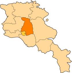
| Marz (Province) | Kotayk |
| Founded | 1831 |
| Government | |
| • Mayor | Arakel Virabyan |
| Area | |
| • Total | 6.22 km2 (2.40 sq mi) |
| Elevation | 1,350 m (4,430 ft) |
| Population (2008) | |
| • Total | 1,337 |
| Time zone | (UTC+4) |
| • Summer (DST) | (UTC+5) |
Ptghni (Armenian: Պտղնի, also Romanized as Ptykhni, Ptgni, and Ptkhni) is a village located in the Kotayk Province of Armenia along the left bank of the Hrazdan River. It was founded in 1831 in the vicinity of an abandoned dwelling. The village has a house of culture, school, kindergarten, and a library. Local inhabitants predominantly grow grapes, melons, gourds, and breed cattle.
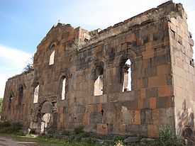
Within the village are the remains of fortress walls and Ptghavank of the 6th to 7th century.
Gallery
-
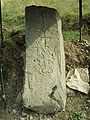
Khachkar monument beside the highway leading through Ptghni.
References
- Ptghni at GEOnet Names Server
- World Gazeteer: Armenia – World-Gazetteer.com
- Report of the results of the 2001 Armenian Census, National Statistical Service of the Republic of Armenia
- Ptghnavank Monastery
- Ptghnavank2
- Ptghnavank3
- Ptghnavank4
- Ptghnavank5
External links
- Communities Association of Armenia: Ptghni
- Ptghnavank MonasteryPtghnavank2Ptghnavank3Ptghnavank4Ptghnavank5