Psarades
| Psarades Ψαράδες | |
|---|---|
|
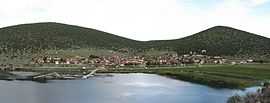
Panorama of Psarades. | |
 Psarades | |
|
Location within the regional unit | |
| Coordinates: 40°49.8′N 21°1.9′E / 40.8300°N 21.0317°ECoordinates: 40°49.8′N 21°1.9′E / 40.8300°N 21.0317°E | |
| Country | Greece |
| Administrative region | West Macedonia |
| Regional unit | Florina |
| Municipality | Prespes |
| Municipal unit | Prespes |
| Elevation | 450 m (1,480 ft) |
| Time zone | EET (UTC+2) |
| • Summer (DST) | EEST (UTC+3) |
| Postal code | 530 77 |
| Area code(s) | +30-2385-xxx-xxx |
| Vehicle registration | PAx-xxxx |
Psarades (Greek: Ψαράδες, Macedonian: Нивици, Bulgarian: Нивици) is a village and a community of the Prespes municipality.[1] Before the 2011 local government reform it was part of the municipality of Prespes, of which it was a municipal district.[1][2] The 2011 census recorded 83 inhabitants in the village.[3] The community of Psarades covers an area of 41.064 km2.[2]
See also
References
- ↑ 1.0 1.1 Kallikratis law Greece Ministry of Interior (Greek)
- ↑ 2.0 2.1 Πίνακας 3. Πραγματικός πληθυσμός, επιφάνεια και πυκνότητα του πληθυσμού, με διάκριση σε αστικές και αγροτικές περιοχές καθώς και σε πεδινές, ημιορεινές και ορεινές περιοχές. Μέσος σταθμικός των υψομέτρων. (in Greek). Ελληνική Στατιστική Αρχή (Hellenic Statistical Authority). Retrieved 11 December 2013.
- ↑
| ||||||||||