Provinces of Mongolia
| Administrative divisions of Mongolia |
|---|
| First level |
| Province aimag (аймаг) |
| Second level |
| District sum (сум) |
| Third level |
| Subdistrict bag (баг) |
 |
| This article is part of a series on the politics and government of Mongolia |
|
|
Politics portal |
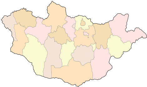
Mongolia is divided into 21 Provinces (Mongolian: аймаг, often translated as aimags. Each aimag is subdivided into several districts.[1][2] The name aimag is derived from the Mongolian word for "tribe". The modern provinces have been established since 1921. The capital, Ulaanbaatar, is governed as an independent provincial municipality separate from Töv Province, inside which it is situated.
List of Provinces
|
|
| Seal | Provinces (Aimags)[3] | Mongolian | Population 2010 Census[4] |
Area (km²)[5] |
Density (/km²) |
Capital |
|---|---|---|---|---|---|---|
 |
Arkhangai | Архангай ᠠᠷᠤᠬᠠᠩᠭᠠᠢ |
84,584 | 55,313.82 | 1.53 | Tsetserleg (Цэцэрлэг) ᠴᠡᠴᠡᠷᠯᠢᠭ |
| Bayankhongor | Баянхонгор ᠪᠠᠶ᠋ᠠᠩᠬᠣᠩᠭ᠋ᠤᠷ |
76,085 | 115,977.80 | 0.66 | Bayankhongor (Баянхонгор) ᠪᠠᠶ᠋ᠠᠩᠬᠣᠩᠭ᠋ᠤᠷ | |
| Bayan-Ölgii | Баян-Өлгий ᠪᠠᠶᠠᠨ ᠥᠯᠦᠭᠡᠢ |
88,056 | 45,704.89 | 1.93 | Ölgii (Өлгий) ᠥᠯᠦᠭᠡᠢ | |
| Bulgan | Булган ᠪᠤᠯᠠᠭᠠᠨ |
53,655 | 48,733.00 | 1.10 | Bulgan (Булган) ᠪᠤᠯᠠᠭᠠᠨ | |
 |
Darkhan-Uul | Дархан-Уул ᠳᠠᠷᠬᠠᠨ ᠠᠭᠤᠯᠠ |
94,625 | 3,275.00 | 28.89 | Darkhan (Дархан) ᠳᠠᠷᠬᠠᠨ |
 |
Dornod | Дорнод ᠳᠣᠷᠤᠨᠠᠳᠤ |
69,552 | 123,597.43 | 0.56 | Choibalsan (Чойбалсан) ᠴᠣᠶᠢᠪᠠᠯᠰᠠᠩ |
| Dornogovi | Дорноговь ᠳᠣᠷᠤᠨᠠᠭᠣᠪᠢ |
58,612 | 109,472.30 | 0.54 | Sainshand (Сайншанд) ᠰᠠᠶᠢᠩᠰᠠᠩᠳᠠ | |
 |
Dundgovi | Дундговь ᠳᠤᠮᠳᠠᠭᠣᠪᠢ |
38,821 | 74,690.32 | 0.52 | Mandalgovi (Мандалговь) ᠮᠠᠨᠳᠠᠯᠭᠣᠪᠢ |
| Govi-Altai | Говь-Алтай ᠭᠣᠪᠢ ᠠᠯᠲᠠᠢ |
53,590 | 141,447.67 | 0.38 | Altai (Алтай) ᠠᠯᠲᠠᠢ | |
| Govisümber | Говьсүмбэр ᠭᠣᠪᠢ ᠰᠦᠮᠪᠦᠷ |
13,240 | 5,541.80 | 2.39 | Choir (Чойр) ᠴᠣᠶᠢᠷ | |
| Khentii | Хэнтий ᠺᠡᠨᠲᠡᠢ |
65,811 | 80,325.08 | 0.82 | Öndörkhaan (Өндөрхаан) ᠥᠨᠳᠦᠷᠬᠠᠨ | |
| ] align="center"| |
Khovd | Ховд ᠬᠣᠪᠲᠤ |
76,870 | 76,060.38 | 1.01 | Khovd (Ховд) ᠬᠣᠪᠲᠤ |
 |
Khövsgöl | Хөвсгөл ᠺᠥᠪᠰᠦᠭᠦᠯ |
114,926 | 100,628.82 | 1.14 | Mörön (Мөрөн) ᠮᠥᠷᠡᠨ |
 |
Orkhon | Орхон ᠣᠷᠬᠣᠨ |
90,700 | 844.00 | 107.46 | Erdenet (Эрдэнэт) ᠡᠷᠳᠡᠨᠢᠲᠦ |
| Selenge | Сэлэнгэ ᠰᠡᠯᠡᠩᠭᠡ |
97,585 | 41,152.63 | 2.37 | Sükhbaatar (Сүхбаатар) ᠰᠦᠺᠡᠪᠠᠭᠠᠲᠤᠷ | |
| Sükhbaatar | Сүхбаатар ᠰᠦᠺᠡᠪᠠᠭᠠᠲᠤᠷ |
51,334 | 82,287.15 | 0.62 | Baruun-Urt (Баруун-Урт) ᠪᠠᠷᠠᠭᠤᠨ ᠤᠷᠲᠤ | |
 |
Töv | Төв ᠲᠥᠪ |
85,166 | 74,042.37 | 1.15 | Zuunmod (Зуунмод) ᠵᠠᠭᠤᠨᠮᠣᠳᠤ |
| Ömnögovi | Өмнөговь ᠡᠮᠦᠨᠡᠭᠣᠪᠢ |
61,314 | 165,380.47 | 0.37 | Dalanzadgad (Даланзадгад) ᠳᠠᠯᠠᠨᠵᠠᠳᠠᠭᠠᠳ | |
 |
Uvs | Увс ᠤᠪᠰᠤ |
73,323 | 69,585.39 | 1.05 | Ulaangom (Улаангом) ᠤᠯᠠᠭᠠᠩᠭ᠋ᠣᠮ |
| Övörkhangai | Өвөрхангай ᠥᠪᠦᠷᠬᠠᠩᠭᠠᠢ |
101,314 | 62,895.33 | 1.61 | Arvaikheer (Арвайхээр) ᠠᠷᠪᠠᠶᠢᠬᠡᠭᠡᠷ | |
 |
Zavkhan | Завхан ᠵᠠᠪᠬᠠᠨ |
65,481 | 82,455.66 | 0.79 | Uliastai (Улиастай) ᠤᠯᠢᠶ᠋ᠠᠰᠤᠲᠠᠢ |
Past provincial population
*- Govisümber aimag was split from Dornogovi aimag in 1994.
| Province | 1979-01-05 Census |
1989-01-05 Census |
2000-01-05 Census |
2009-12-31 est.[6] |
|---|---|---|---|---|
| Arkhangai | 77,575 | 84,517 | 97,091 | 92,449 |
| Bayan-Ölgii | 71,416 | 90,911 | 91,068 | 101,848 |
| Bayankhongor | 63,048 | 74,574 | 84,779 | 85,365 |
| Bulgan | 42,398 | 51,910 | 61,776 | 62,340 |
| Darkhan-Uul | 50,572 | 85,737 | 83,271 | 90,050 |
| Dornod | 58,860 | 81,073 | 75,373 | 73,625 |
| Dornogovi | 42,349 | 57,103 | 50,575 | 58,318 |
| Dundgovi | 38,937 | 49,320 | 51,517 | 47,671 |
| Govi-Altai | 55,884 | 62,773 | 63,673 | 59,376 |
| Govisümber | -* | -* | 12,230 | 13,293 |
| Khentii | 52,784 | 73,804 | 70,946 | 71,458 |
| Khovd | 62,565 | 76,553 | 86,831 | 88,505 |
| Khövsgöl | 88,500 | 101,833 | 119,063 | 124,108 |
| Ömnögovi | 32,929 | 42,445 | 46,858 | 49,333 |
| Orkhon | 31,851 | 56,136 | 71,525 | 83,145 |
| Övörkhangai | 82,504 | 96,510 | 111,420 | 117,513 |
| Selenge | 65,118 | 86,952 | 99,950 | 103,459 |
| Sükhbaatar | 43,229 | 50,846 | 56,166 | 54,955 |
| Töv | 80,547 | 100,088 | 99,268 | 88,503 |
| Uvs | 72,302 | 83,958 | 90,037 | 78,801 |
| Zavkhan | 79,990 | 88,518 | 89,999 | 79,320 |
| Ulan Bator | 403,000 | 548,400 | 760,077 | 1,240,037 |
History

During the Qing Dynasty, the territory of Outer Mongolia was divided (from east to west) into the Setsen Khan, Tüsheet Khan, Sain Noyon Khan, and Zasagt Khan provinces plus the Khovd area. The northern border to Russia was guarded by a watch post area. After Mongolia's second declaration of independence in 1921, the provinces were renamed in 1923, to Khaan Khentii Uulyn Province, Bogd Khan Uulyn Province, Tsetserleg Mandal Uulyn Province, and Khan Taishir Uulyn Province, respectively. The Khovd area and the Jebtsundamba Khutughtu's great shabi (personal fiefdom) turned into provinces of their own, Chandmani Uulyn Province and Delger Ikh Uulyn Province, respectively (the latter was later merged with Tsetserleg Mandal Uulyn Province). But otherwise the administrative structure was largely left unchanged until the 1930s.
An administrative reorganisation was initiated in 1931, which resulted in the Provinces Khovd, Dörvöd (later renamed Uvs), Altai (later renamed Govi-Altai), Khövsgöl, Zavkhan, Arkhangai, Övörkhangai, Ömnögovi, Tariachin (later split into parts of Bulgan and Selenge), Töv, Dornogovi, Khentii and Dornod (later renamed to Choibalsan). The Bayankhongor, Bayan-Ölgii, Bulgan, Dundgovi, Sükhbaatar, and Selenge provinces were created in the 1930s and 1940s.
The Choibalsan Province was re-renamed to Dornod Province in 1963, and the capital Ulan Bator was split from Töv Province as a separate district. The same status was given to the newly founded industrial cities of Darkhan (1961 in the Selenge Province) and Erdenet (1975 in the Bulgan Province). In 1994, two Sums of the Bulgan Province were taken to build the Orkhon Province around Erdenet, and four Sums of the Selenge Province to build the Darkhan-Uul Province around Darkhan, ending the special status of the two cities.
See also
- Aimag
- Districts of Mongolia
- ISO 3166-2 codes for Mongolia
- List of political and geographic subdivisions by total area
References
- ↑ Mongolian constitution, article 57
- ↑ Montsame News Agency. Mongolia. 2006, Foreign Service office of Montsame News Agency, ISBN 99929-0-627-8, p. 46
- ↑ "Provinces of Mongolia". InfoMongolia.com. MER. Retrieved 17 December 2014.
- ↑ Mongolia National Census 2010 official site. Aimags: Interactive Map.
- ↑ Mongolia Landuse Annual Report 2007
- ↑ Mongolia National Census 2010 preliminary results
| |||||||||||||||||||||||||||||||||||||||||
| ||||||||||||
| ||||||||||||||||||
