Province of Turin
| Province of Turin | |
|---|---|
| Province | |
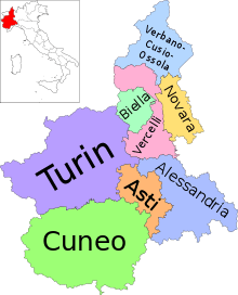
 Map highlighting the location of the province of Turin in Italy | |
| Country |
|
| Region | Piedmont |
| Capital(s) | Turin |
| Comuni | 315 |
| Government | |
| • President | Antonino Saitta |
| Area | |
| • Total | 6,821 km2 (2,634 sq mi) |
| Population (03-31-2012) | |
| • Total | 2,308,409 |
| • Density | 340/km2 (880/sq mi) |
| Time zone | CET (UTC+1) |
| • Summer (DST) | CEST (UTC+2) |
| Postal code |
10010-10020, 10022-10026, 10028-10032, 10034-10038, 10040-10046, 10048, 10050-10078, 10080-10088, 10090-10095, 10098-10100 |
| Telephone prefix |
011, 0121, 0122, 0123, 0124, 0125, 0161 |
| Vehicle registration | TO |
| ISTAT | 001 |
The Province of Turin (Italian: Provincia di Torino; Piemontese: Provincia ëd Turin; French: Province de Turin) was a province in the Piedmont region of Italy. Its was capital is the city of Turin. Province existed to 31 December 2014.
It has an area of 6,830 km2 (2,640 sq mi),[1] and a total population of 2,306,676 (30 June 2011).[2] There are 315 comuni in the province[3] – the most of any province in Italy. The second highest comunis are in the Province of Cuneo which has 250. Torino, the regional capital of the province was the first Italian national capital in 1861.[4] The most important export items from Turin are cars, machinery, metal and metal products. The province has commercial relations with Germany, France, Poland, Spain, United Kingdom, Romania and Czech Republic. A large quantity of import and export is carried with these nations. Service is the most important economic sector accounting to 66% of the Gross Domestic Product. The other two important sectors are Industry (32%) and agriculture(2%).[4] To promote entrepreneurship the provincial body has started- Start your own business (Italian: Mettersi in Proprio), a advice service to help aspiring entrepreneurs who have new business ideas.[4]
Geography
The province consists of a mountainous area to the west and north along the border with France and with the Valle d'Aosta,[5] and part flat or hilly in the south and east. The mountainous part is home to part of the Hautes Alpes, the Alps Graie and, in a much lesser extent, in the Pennine Alps. The highest point in the province of Turin is made from the tower of the Roc (4,026 m), located in the Gran Paradiso massif on the border with Valle d'Aosta. Several wildlife reserves are located in the province. Some of them are Sacro Monte Natural Reserve in Belmonte and the Gran Paradiso National Park. It also has a UNESCO World Heritage Site.[5]
As of December 31, 2010, the largest comuni by population are:
| Rank | Commune of | Population | Area (km2) |
Density (inhabitants/km2) |
Altitude (mslm) |
|---|---|---|---|---|---|
| 1st | Torino | 907563 | 130.7 | 6943.9 | 239 |
| 2nd | Moncalieri | 58320 | 47.3 | 1233 | 260 |
| 3rd | Collegno | 50137 | 18.0 | 2785.4 | 302 |
| 4th | Rivoli | 49591 | 29.2 | 1698.3 | 352 |
| 5th | Nichelino | 48946 | 20.4 | 2399.3 | 229 |
| 6th | Settimo Torinese | 47988 | 32.7 | 1467.5 | 207 |
| 7th | Grugliasco | 37870 | 13 | 2913.1 | 293 |
| 8th | Chieri | 36168 | 50 | 723.4 | 376 |
| 9th | Pinerolo | 36158 | 54 | 667 | 305 |
| 10th | Venaria Reale | 34859 | 20 | 1743 | 262 |


See also
- Shroud of Turin
- House of Savoy
- Italian language
- Piedmontese language
- Franco-Provençal language
- Sacro Monte di Belmonte
- Residences of the Royal House of Savoy
- Parco Nazionale del Gran Paradiso
References
- ↑ "ISTAT - Superficie dei comuni, province e regioni al Censimento 2011". ISTAT (in Italian). Retrieved 14 September 2014.
- ↑ "Dato ISTAT al 31 dicembre 2013". ISTAT (in Italian). Retrieved 14 September 2014.
- ↑ "Comunis in Turin" (in Italian). Retrieved 14 September 2014.
- ↑ 4.0 4.1 4.2 "Province of Turin". Energeia. Retrieved 14 September 2014.
- ↑ 5.0 5.1 "Turin - Piedmont". ITALIA. Retrieved 14 September 2014.
External links
| ||||||||||||||