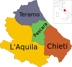
Province of L'Aquila
| Province of L'Aquila | |
|---|---|
| Province | |
 Map highlighting the location of the province of L'Aquila in Italy | |
| Country |
|
| Region | Abruzzo |
| Capital(s) | L'Aquila |
| Comuni | 108 |
| Government | |
| • President | Antonio Del Corvo |
| Area | |
| • Total | 5,034 km2 (1,944 sq mi) |
| Population (2012) | |
| • Total | 310,067 |
| • Density | 62/km2 (160/sq mi) |
| Time zone | CET (UTC+1) |
| • Summer (DST) | CEST (UTC+2) |
| Postal code | 67100, 67010, 67012, 67013, 67014, 67015, 67017, 67019, 67020, 67021, 67022, 67023, 67024, 67025, 67026, 67027, 67028, 67029, 67030, 67031, 67032, 67033, 67034, 67035, 67036, 67037, 67038, 67039, 67040, 67041, 67043, 67044, 67045, 67046, 67047, 67048, 67049, 67050, 67051, 67052, 67053, 67054, 67055, 67056, 67057, 67058, 67059, 67060, 67061, 67062, 67063, 67064, 67066, 67067, 67068, 67069 |
| Telephone prefix | 0862, 0863, 0864 |
| Vehicle registration | AQ |
| ISTAT | 066 |
The Province of L'Aquila (Provincia dell'Aquila) is the largest, most mountainous and least densely populated province of the Abruzzo region of Southern Italy. It comprises about half the landmass of Abruzzo and occupies the western part of the region. It has borders with the provinces of Teramo to the north, Pescara and Chieti to the east, Isernia (in Molise region) to the south and Frosinone, Rome and Rieti (in Lazio region) to the west. Its capital is the city of L'Aquila. The Province of L'Aquila includes the highest mountains of the Apennines (Gran Sasso, Maiella and Velino-Sirente), their highest peak, Corno Grande, the high plain of Campo Imperatore, and Europe's southernmost glacier, the Calderone. The province's major rivers are the Aterno-Pescara, Sangro, Liri, Salto, and the Turano; its major lakes are Lago Scanno and Lago Barrea. It once included the largest lake on the Italian peninsula, Lago Fucino, which was drained in one of the 19th century's largest engineering projects. The lake basin is today a flourishing agricultural area and an important technological district.
Economy and population
The province is known for its many castles, fortresses and pristine medieval hill towns. The province's two major cities, L'Aquila and Avezzano, have had rapid economic expansion since the late 20th century, with the growth of transportation manufacturing, telecommunications, and computer industries.
Throughout most of the 20th century, there were serious population declines in the rural areas, with the near collapse of the province's pastoral agricultural economy, as people moved to cities for work. Since the founding of the Gran Sasso e Monti della Laga and Majella national parks, and the Sirente-Velino Regional Park, tourists have been attracted to the mountainous landscapes. Tourism and associated services have boosted the economy of rural L'Aquila and begun to reverse its population decline.
The province has an area of 5,034 square kilometres (1,944 sq mi) and a total population of 297,592 (2001).
Earthquakes
Earthquakes mark the history of the province, especially its capital city L'Aquila. The city suffered earthquakes in the 14th, 15th, and 16th centuries[1][2] and most recently on April 6, 2009. This caused extensive damage to the city and areas of the province just outside l'Aquila, particularly along SS 17. At 01:32 GMT (03:32 CEST) on April 6, an earthquake of 6.3 magnitude struck central Italy with its epicentre near L'Aquila, at 42°25′22″N 13°23′40″E / 42.4228°N 13.3945°E.[3]
Cities and towns

The largest are:
| Comune | Inhabitants |
|---|---|
| L'Aquila | 71,761 |
| Avezzano | 39,670 |
| Sulmona | 25,363 |
| Celano | 11,012 |
| Pratola Peligna | 7,890 |
| Tagliacozzo | 6,820 |
| Trasacco | 6,115 |
| Castel di Sangro | 6,109 |
| Luco dei Marsi | 5,776 |
| Capistrello | 5,473 |
| Carsoli | 5,238 |
See also
- Comunes of the Province of L'Aquila
Gallery
-
Corno Grande, the Italian peninsula’s tallest peak
-

Santa Maria della Pietà and Rocca Calascio
-

Campo Imperatore in spring
References
- ↑ "L'Aquila, prov. of L'Aquila, Abruzzo". Abruzzo2000.com. Retrieved 2009-04-06.
- ↑ http://www.earth-prints.org/bitstream/2122/1777/1/03%20d'addezio.pdf
- ↑ http://earthquake.usgs.gov/eqcenter/catalogs/eqs1day-M1.txt
External links
- (Italian) Provincia dell'Aquila Official website
| ||||||||||

