Province of Brescia
| Province of Brescia | |
|---|---|
| Province | |
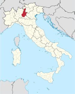 Map highlighting the location of the province of Brescia in Italy | |
| Coordinates: 45°38′N 10°18′E / 45.633°N 10.300°ECoordinates: 45°38′N 10°18′E / 45.633°N 10.300°E | |
| Country |
|
| Region | Lombardy |
| Capital(s) | Brescia |
| Comuni | 206 |
| Government | |
| • President | Daniele Molgora (LN) |
| Area[1] | |
| • Total | 4,784.28 km2 (1,847.22 sq mi) |
| Population (31 December 2012)[2] | |
| • Total | 1,247,192 |
| • Density | 260/km2 (680/sq mi) |
| Time zone | CET (UTC+1) |
| • Summer (DST) | CEST (UTC+2) |
| Telephone prefix | 030 |
| Vehicle registration | BS |
| Website | Official website |
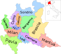
The Province of Brescia is a Province in Lombardy, Italy. It borders with the province of Sondrio to the North and North West, the province of Bergamo to the West, the province of Cremona to the South West and South, the province of Mantua to the South, and to the east the province of Verona (which is part of the Veneto region) and Trentino (which is part of the Trentino-Alto Adige/Südtirol region).
The province of Brescia stretches between Lake Iseo in the west, Lake Garda in the east, the Southern Rhaetian Alps in the north and the Lombardian plains in the south. The main rivers of the province are the Oglio, the Mella and the Chiese.
Important towns in the province: Brescia (the capital), Darfo Boario Terme, Desenzano del Garda, Palazzolo sull'Oglio, Montichiari, Ghedi, Manerbio, Carpenedolo, Orzinuovi, Chiari, Rovato, Gussago, Salò, Iseo, Gardone Val Trompia, Rezzato and Lumezzane.
UNESCO World Heritage Sites
- Rock Drawings in Valcamonica;
- Brescia, one of the places of Longobard power;
- Prehistoric settlements of Lavagnone (Desenzano del Garda), Lugana Vecchia (Sirmione), Lucone (Polpenazze del Garda), San Sivino and Gabbiano (Manerba del Garda).
Most populated municipalities
| Rank | City | Population | Area (km2) |
Density (inhabitants/km2) |
Altitude (mslm) |
|---|---|---|---|---|---|
| 1st | Brescia | 194376 | 90.68 | 2143.5 | 149 |
| 2nd | Desenzano del Garda | 27743 | 60.1 | 461.6 | 67 |
| 3rd | Montichiari | 24026 | 81.19 | 295.9 | 108 |
| 4th | Lumezzane | 23790 | 31.52 | 754.8 | 460 |
| 5th | Palazzolo sull'Oglio | 20208 | 23.06 | 869.4 | 166 |
| 6th | Chiari | 19037 | 38.02 | 500.7 | 145 |
| 7th | Ghedi | 18966 | 60.76 | 312.1 | 85 |
| 8th | Rovato | 18900 | 26.1 | 724.1 | 192 |
| 9th | Gussago | 16878 | 25.02 | 674.6 | 190 |
| 10th | Lonato del Garda | 15877 | 70.5 | 225.2 | 188 |
See also
- Communes of the province of Brescia
References
External links
| ||||||||||