Pripyat River
| Pripyat River | |
|---|---|
 | |
| Origin | Ukraine |
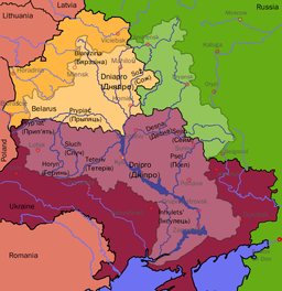
| Mouth | Dnieper |
| Basin countries | Ukraine, Belarus |
| Length | 761 km (473 mi) |
| Source elevation | |
| Avg. discharge | 377 m3/s |
| Basin area | 121,000 km2 (47,000 sq mi) |
| Left tributaries | Pina, Yaselda, Tsna, Lan, Sluch, Ptsich, Braginka |
| Right tributaries | Horyn, Stokhid, Styr, Turija, Ubort, Zhelon, Slovechna, Uzh |
The Pripyat River or Prypiat River (Ukrainian: Прип’ять, pronounced [ˈprɪpjɑtʲ]; Belarusian: Прыпяць, Prypiać, [ˈprɨpʲatsʲ]; Polish: Prypeć, [ˈprɨpɛtɕ]; Russian: Припять, [ˈprʲipʲɪtʲ]) is a river in Eastern Europe, approximately 761 km (473 mi) long.[1] It flows east through Ukraine, Belarus, and Ukraine again, draining into the Dnieper.
The Pripyat passes through an exclusion zone established around the site of the Chernobyl nuclear disaster. It is polluted with radionuclides. The concentration of caesium-137 in river sediments continues to increase. The city of Prypiat, Ukraine (population 45,000) was completely evacuated after the Chernobyl disaster.
Pripyat has catchment area of 121,000 km2 (47,000 sq mi), 50,900 km2 (19,700 sq mi) of which are in Belarus. 495 km (308 mi) of the whole river length lies within territory of Belarus.[1]
Name etymology


At least three etymologies have been proposed for the name:-
- In Slavic languages, the component "pri" means "near", and the component "pyat" means "5". This river has a confluence with five other rivers.
- It might derive from the local word pripech used for a river with sandy banks.[2]
- From a Western-Baltic name Preipente "the river at (till) the spurs", the Pripyat river being very shallow in the area inhabited by Western Balts.
See also
References
- ↑ 1.0 1.1 "Main Geographic Characteristics of the Republic of Belarus. Main characteristics of the largest rivers of Belarus". Land of Ancestors. Data of the Ministry of Natural Resources and Environmental Protection of the Republic of Belarus. 2011. Retrieved 27 September 2013.
- ↑ Room, Adam (1997). Placenames of the World. Jefferson, North Carolina: McFarland.
External links
| Wikimedia Commons has media related to Prypyat River. |
Books
- (in Russian, English and Polish) Ye.N.Meshechko, A.A.Gorbatsky (2005) Belarusian Polesye: Tourist Transeuropean Water Mains, Minsk, Four Quarters,
- (in Belorussian, Russian and English) T.A.Khvagina (2005) POLESYE from the Bug to the Ubort, Minsk Vysheysha shkola, ISBN 985-06-1153-7.
| |||||||||||||||||||||||||||||
Coordinates: 51°09′31″N 30°29′27″E / 51.15861°N 30.49083°E