Pripyat
| Pripyat При́п'ять | |
|---|---|
| City of regional significance | |
 | |
 Pripyat | |
 Pripyat | |
| Coordinates: 51°24′20″N 30°03′25″E / 51.40556°N 30.05694°E | |
| Country |
|
| Oblast | Kiev Oblast |
| Raion |
Chernobyl Raion (1923–1988) Ivankiv Raion (since 1988) |
| Founded | 4 February 1970 |
| City rights | 1979 |
| Government | |
| • Administration | State Agency of Ukraine on the Exclusion Zone Management |
| Population (2015) | |
| • Total | 0 |
| Time zone | EET (UTC+2) |
| • Summer (DST) | EEST (UTC+3) |
| Postal code | none (formerly 01196) |
| Area code(s) | +380 4499[1] |
Pripyat or Pripiat (Ukrainian: При́п'ять, Prýp'jat́; Russian: При́пять, Pri'pyatï’ ![]() Pronunciation) is an abandoned city in northern Ukraine, near the border with Belarus.
Pronunciation) is an abandoned city in northern Ukraine, near the border with Belarus.
Named after the nearby Pripyat River, Pripyat was founded on 4 February 1970, the ninth nuclear city in the Soviet Union, to serve the nearby Chernobyl Nuclear Power Plant.[2] It was officially proclaimed a city in 1979, and had grown to a population of 49,360[3] by the time it was evacuated, a few days after the 26 April 1986 Chernobyl disaster.
Though Pripyat is located within the administrative district of Ivankiv Raion, the abandoned city now has a special status within the larger Kiev Oblast (province), being administered directly from Kiev. Pripyat is also supervised by Ukraine's Ministry of Emergencies, which manages activities for the entire Chernobyl Exclusion Zone.
Background


Access to Pripyat, unlike cities of military importance, was not restricted before the disaster as nuclear power stations were seen by the Soviet Union as safer than other types of power plants. Nuclear power stations were presented as being an achievement of Soviet engineering, where nuclear power was harnessed for peaceful projects. The slogan "peaceful atom" (Russian: мирный атом, mirnıy atom) was popular during those times. The original plan had been to build the plant only 25 km (16 mi) from Kiev, but the Ukrainian Academy of Sciences, among other bodies, expressed concern about it being too close to the city. As a result, the power station and Pripyat[4] were built at their current locations, about 100 km (62 mi) from Kiev. After the disaster the city of Pripyat was evacuated in two days.[5]

Infrastructure and statistics
The following statistics are from January 1, 1986.[6]
- Population: 49,400 before the disaster. The average age was about 26 years old. Total living space was 658,700 m2 (7,090,000 sq ft): 13,414 apartments in 160 apartment blocks, 18 halls of residence accommodating up to 7,621 single males or females, and 8 halls of residence for married or de facto couples.
- Education: 15 primary schools for about 5,000 children, 5 secondary schools, 1 professional school.
- Healthcare: 1 hospital that could accommodate up to 410 patients, and 3 clinics.
- Trade: 25 stores and malls; 27 cafes, cafeterias and restaurants could serve up to 5,535 customers simultaneously. 10 warehouses could hold 4,430 tons of goods.
- Culture: 3 facilities: a culture palace, a cinema and a school of arts, with 8 different societies.
- Sports: 10 gyms, 3 indoor swimming-pools, 10 shooting galleries, 2 stadia.
- Recreation: 1 park, 35 playgrounds, 18,136 trees, 249,247 shrubs, 33,000 rose plants.
- Industry: 4 factories with total annual turnover of 477,000,000 rubles. 1 nuclear power plant.
- Transportation: Yanov railway station, 167 urban buses, plus the nuclear power plant car park of about 400 units.
- Telecommunication: 2,926 local phones managed by the Pripyat Phone Company, plus 1,950 phones owned by Chernobyl power station's administration, Jupiter plant and Department of Architecture and Urban Development.
Post-Chernobyl years


In 1986 the city of Slavutich was constructed to replace Pripyat. After the city of Chernobyl, this is the second-largest city for accommodating power plant workers and scientists in the Commonwealth of Independent States (CIS).
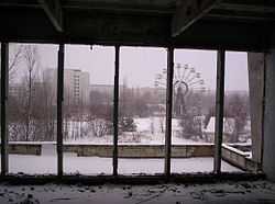
One notable landmark often featured in photographs of the city and visible from aerial-imaging websites is the long-abandoned Ferris wheel located in the Pripyat amusement park.
Safety
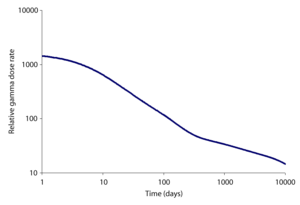
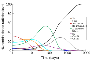
A natural concern is whether it is safe to visit Pripyat and the surroundings. The Zone of Alienation is considered relatively safe to visit, and several Ukrainian companies offer guided tours around the area. The radiation levels have dropped considerably, compared to the fatal levels of April 1986, due to the decay of the short-lived isotopes released during the accident. In most places within the city, the level of radiation does not exceed an equivalent dose of 1 μSv (one microsievert) per hour.[7]
Cultural references
- In 2006, musician Example features Pripyat in his 18-minute documentary of the ghost town, and for his promotional video for his track "What We Made".
- The city of Pripyat is the location of filming of the 2008 documentary White Horse.[8]
- The exclusion zone is the setting for Karl Schroeder's science fiction short story "The Dragon of Pripyat".
- In 2015, Urban Explorers from the group TiedTo111 abseiled a Soviet apartment block and the Ferris wheel in Pripyat.
- Lara Croft visits Pripyat in episode 7 of her new comic.[2014]
- Pripyat plays an important role in the video games S.T.A.L.K.E.R.: Shadow of Chernobyl and its sequel S.T.A.L.K.E.R.: Call of Pripyat; in both the player is able to visit and explore various parts of the city.
- The novel Wolves Eat Dogs by Martin Cruz Smith uses Pripyat as the setting for an investigation by Arkady Renko.
- Much of the James Rollins novel The Last Oracle takes place in Pripyat and around Chernobyl. The story revolves around a team of American "Killer Scientist" special agents who must stop a terrorist plot to unleash the radiation of Lake Karachay on the world during the installation of the new sarcophagus over the Chernobyl nuclear power plant.
- The city is also the setting for two missions in Call of Duty 4: Modern Warfare based around the main square and the amusement park, set after the disaster. Also the multiplayer maps "Bloc" and "Vacant" in the game take place in Pripyat. A small part of the city is seen briefly in a flashback in Call of Duty: Modern Warfare 3, and the multiplayer map "Fallen" takes place in Pripyat. Call of Duty: Black Ops features a map called "Grid", which takes place in Pripyat. A level in Call of Duty: Modern Warfare 2 and a multiplayer map called "Wasteland" takes place in Pripyat and near Chernobyl, respectively.
- The American paranormal investigation series Destination Truth conducted an overnight investigation within Pripyat.
- The Northern Irish alternative rock band Ash have a track called "Pripyat" on their 2010 singles collection A–Z Vol. 1.
- Ukrainian singer Alyosha recorded most of the video for her Eurovision 2010 entry Sweet People in Pripyat.
- The beginning of the 2011 movie Transformers: Dark of the Moon takes place at Chernobyl.
- The PBS documentary Radioactive Wolves analyzes and compares the health of wildlife within and without the Exclusion Zone.
- The song "Dead City" (Ukrainian: Мертве Місто) by Ukrainian Symphonic Metal band DELIA is about Pripyat, and scenes from the music video were shot in the city. DELIA's vocalist, Anastasia Sverkunova, was born in Pripyat just before the Chernobyl disaster.[9]
- The majority of the 2011 movie Land of Oblivion was shot on location in Pripyat.
- The 2012 horror movie Chernobyl Diaries was inspired by the Chernobyl Disaster in 1986 and takes place in Pripyat.[10]
- The 2013 film A Good Day to Die Hard is partly set in Pripyat.
- Marillion guitarist Steve Rothery's first solo album is called "The Ghosts of Pripyat" (2014).
- The city of Pripyat is featured in Jeremy Wades River Monsters episode "Atomic Assassin".
- Pripyat is featured in the BBC program Top Gear in 2014, in series 21 episode 3, showing two of the three hosts of the show driving through the abandoned city.
- German pianist and composer Hauschka features Pripyat on the second track of his album Abandoned Cities.
- Pripyat footage is featured in Pink Floyd's video "Marooned", 20th Anniversary Edition.
- Pripyat is featured in the History Channel Documentary called Life After People.
- Filmmaker Danny Cooke used a drone to capture shots of the famously creepy abandoned amusement park, some charming residential shots of decaying walls, children's toys and gas masks. He collected them in a 3-minute short film “Postcards From Chernobyl”, released in November 2014, while making footage for the CBS News 60 Minutes episode in early 2014 “Chernobyl: The Catastrophe That Never Ended”.[11][12]
See also
- Chernobyl Nuclear Power Plant Exclusion Zone
- Elena Filatova
- Alexander Sirota
References
- ↑ "City Phone Codes". Retrieved 2 December 2014.
- ↑ Pripyat: Short Introduction
- ↑ "Chernobyl and Eastern Europe: My Journey to Chernobyl 6". Chernobylee.com. Retrieved 2013-10-15.
- ↑ "History of the Pripyat city creation". Retrieved 2 December 2014.
- ↑ Anastasia. "dirjournal.com". Info Blog. Retrieved 2 December 2014.
- ↑ Припять в цифрах ("Pripyat in Numbers"), a page from Pripyat website
- ↑ http://chernobylgallery.com/chernobyl-disaster/radiation-levels/
- ↑ White Horse at the Internet Movie Database
- ↑ "DELIA". Retrieved 2 December 2014.
- ↑ Chernobyl Diaries at the Internet Movie Database
- ↑ "Witness a Drone's Eye View of Chernobyl's Urban Decay". The Creators Project. Retrieved 2 December 2014.
- ↑ "من فوق.. كيف يبدو ما بقي من تشيرنوبل بعد 30 عاما من الكارثة النووية؟". CNN Arabic. Retrieved 2 December 2014.
| Wikimedia Commons has media related to Pripyat. |
- Abseiling in Pripyat, Chernobyl
- The photobook Chernobyl 1986 by Tom Bossi with images of Pripyat
- Chernobyl Tour & Good Photos
- Pripyat photos from an urban explorer who slept in the zone
- Street View of Pripyat
- Pripyat.com - Site created by former residents
- The Chernobyl Gallery - Photographs of Pripyat and Chernobyl
- Photos from a visit shortly before the zone was closed to visitors
- A visit to Pripyat and the zone of alienation
- Pripyat on Soviet map (1986)
- Pripyat: Ghost City Chronicles
- The Chernobyl Poems of the former inhabitant of Pripyat Lyubov Sirota
- "Our Pripyat" — YouTube channel with some films about Pripyat before Chernobyl catastrophe and to present time.
- Touring Chernobyl In 2010 - A photo tour from 2010 including many photos from Pripyat
- 25 years of satellite imagery over Chernobyl Pripyat map
- Pripyat wall paintings
- "Pripyat in Panoramas" Project
| ||||||||||||||||||||||
| ||||||||||||||||||||||||||||
| ||||||||||||||||||||||||||||||||||||||||||||
Coordinates: 51°24′20″N 30°03′25″E / 51.40556°N 30.05694°E