Printing House Row District
|
South Dearborn Street – Printing House Row North Historic District | |
|
Chicago Landmark | |
 | |
|
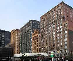
The Manhattan Building (far right), the Fisher Building (far left), and the Old Colony Building (middle-left), three of the four buildings in the district. | |
 | |
| Location | Chicago, IL |
|---|---|
| Coordinates | 41°52′42.48″N 87°37′41.24″W / 41.8784667°N 87.6281222°WCoordinates: 41°52′42.48″N 87°37′41.24″W / 41.8784667°N 87.6281222°W |
| Built | 1889 |
| Architect | Multiple |
| Architectural style | Chicago |
| Governing body | Private |
| NRHP Reference # | 76000705[1] |
| Significant dates | |
| Added to NRHP | January 7, 1976 |
| Designated CL | May 9, 1996 |
The Printing House Row District is a U.S. historic district on the 500 through 800 blocks of South Dearborn, South Federal and South Plymouth streets in the Loop community area of Chicago, Illinois. It was listed on the National Register of Historic Places as South Dearborn Street – Printing House Row Historic District and listed as a National Historic Landmark as South Dearborn Street – Printing House Row North Historic District on January 07, 1976.[2][1] The district was designated a Chicago Landmark on May 9, 1996.[3] The district includes the Monadnock Building, the Manhattan Building, the Fisher Building, and the Old Colony Building.[2] The district overlaps significantly with the Printers Row neighborhood.
It is not the same as South Loop Printing House District which is a different, although perhaps overlapping, district.
Notes
- ↑ 1.0 1.1 "National Register Information System". National Register of Historic Places. National Park Service. 2007-01-23.
- ↑ 2.0 2.1 "South Dearborn Street--Printing House Row North Historic District". National Historic Landmark summary listing. National Park Service. Retrieved 2008-07-20.
- ↑ "Printing House Row District". Chicago Landmarks. City of Chicago. Retrieved 1 December 2013.
External links
-
 Media related to Printing House Row District at Wikimedia Commons
 - Official City of Chicago Loop Community Map
| ||||||||||||||||||||||||||