Prieska
| Prieska | |
|---|---|
|
Prieska | |
 Prieska
| |
| Coordinates: 29°40′6″S 22°44′38″E / 29.66833°S 22.74389°ECoordinates: 29°40′6″S 22°44′38″E / 29.66833°S 22.74389°E | |
| Country | South Africa |
| Province | Northern Cape |
| District | Pixley ka Seme |
| Municipality | Siyathemba |
| Established | 1882 |
| Area[1] | |
| • Total | 195.52 km2 (75.49 sq mi) |
| Population (2011)[1] | |
| • Total | 14,246 |
| • Density | 73/km2 (190/sq mi) |
| Racial makeup (2011)[1] | |
| • Black African | 23.6% |
| • Coloured | 67.4% |
| • Indian/Asian | 0.5% |
| • White | 8.0% |
| • Other | 0.4% |
| First languages (2011)[1] | |
| • Afrikaans | 92.6% |
| • Xhosa | 4.4% |
| • English | 1.0% |
| • Other | 2.0% |
| Postal code (street) | 8940 |
| PO box | 8940 |
| Area code | 053 |
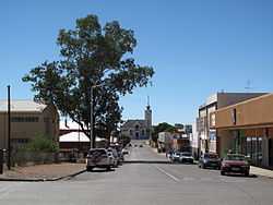
Prieska is a town on the south bank of the Orange River, in the province of the Northern Cape, in western South Africa.
Town on the southern bank of the Orange River, 130 km north-west of Britstown and 75 km south-east of Marydale. It developed from a place to which farmers migrated when the pans were full, after rains. It was administered by a village management board from 1882 and attained municipal status in 1892. The name is derived from Korana and means ‘place of the lost she-goat’.[2]
The town is 240 km south of Kimberley and lies on the R357 road. It was originally named Prieschap, a Khoisan word meaning ‘place of the lost she-goat’. The town was founded in 1882, and in 2011 the town had a population of 14,246.
References
- ↑ 1.0 1.1 1.2 1.3 "Main Place Prieska". Census 2011.
- ↑ "Dictionary of Southern African Place Names (Public Domain)". Human Science Research Council. p. 375.
External links
| Wikimedia Commons has media related to Prieska. |
 |
Marydale | Niekerkshoop | Douglas |  |
| Kenhardt | |
Strydenburg | ||
| ||||
| | ||||
| Copperton | Vosburg | Britstown |
| |||||||||||||||||||||||||||||||||||||||||

.svg.png)