Pride Park
- For the stadium, see Pride Park Stadium.
Pride Park is a business park on the outskirts of the city centre of Derby, England. It covers 80 hectares of former industrial land between the River Derwent and railway lines.
History
The site was formerly part of the railway yards, and was derelict for many years. It was the original site of Derby's railway manufacturing industry, but land here had also been used for gas and coke works, gravel abstraction and landfill. These uses left behind a cocktail of contaminants, including tars, phenols, heavy metals, ammonia and boron. Extensive redevelopment took place over 10 years to reclaim the site, including the building of a new access road to open the area up. Part of the site has been transformed into a nature reserve called "The Sanctuary", in conjunction with Derby City Council.[1]
The Sanctuary Bird Reserve

This 10 hectare site adjacent to Derby County F.C. stadium and the River Derwent was heavily contaminated from its former use as a gas works. The land had been designated a "Site of Interest for Nature Conservation" in the master plan by the council. Part of the site was used in 2003 to safely encapsulate contaminated material removed from other areas of Pride Park, but in 2001 the site was found to be home to ground nesting birds and passage migrants and a plan was created to protect their grassland habitat and to encourage their nesting by creating 'the city's first bird reserve'.
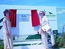
The Sanctuary Bird and Wildlife Reserve was formally launched in July 2004 by the Secretary of State for the Environment, Margaret Beckett MP, alongside the Mayor of Derby.[2] The site is now home to breeding skylark, Reed Bunting and lapwing, all birds considered significant under the UK Biodiversity Action Plan (UK BAP), with additional habitat created for breeding Sand Martin and Little Ringed Plover.
The Sanctuary is not an open access area, but four viewing points are provided on the perimeter for the public.[3] In 2005 The Sanctuary received both a Green Apple Award, and a Green Infrastructure Award from the East Midlands Regional Assembly.[4] In 2006 it was designated a Local Nature Reserve.[5][6]
In February 2005 a Dartford Warbler spent six weeks at The Sanctuary, attracting large numbers of bird watchers. It had not been seen in Derbyshire since a pair were shot at Melbourne Common in the winter of 1840.[7][8]
In July 2013 the breeding success of Little Ringed Plover at The Sanctuary was publicly announced, following concerns that plans to build an outdoor racing circuit linked to a nearby velodrome on top of the bird reserve would significantly damage the Local Nature Reserve.[9]
Occupants
- It has been home of Derby County F.C.'s Pride Park Stadium since 1997 when they relocated from the Baseball Ground in the Normanton district.
- A Park & Ride car park for access to Derby city centre is located next to the stadium.
- Internet bank Egg plc had its headquarters and call centre in the business park until 2011 when it was taken over by Barclaycard, and closed. The building was subsequently occupied by HEROtsc, retaining its function as a call centre.[10]
- The business park also houses a Holiday Inn Express hotel and several car dealerships.
- The sports goods retailer JJB Sports has offices on the Park.
- Pride Park Velodrome is currently under construction adjacent to Pride Park Stadium and is scheduled for completion in 2014.
Expansion Plan
Derby County Football Club are proposing to expand facilities on offer around the football stadium with a £20 million development plan.[11] This is despite the club being unsuccessful in their bid to include the stadium as a venue in England's bid to host the 2018 FIFA World Cup.[12]
On 3 October 2011, Derby County Football Club announced that they had submitted plans to Derby City Council for a £7 million development of land outside Pride Park Stadium, which the club named "The Plaza @ Pride Park".[13]
These plans include five cafes/restaurants, two convenience stores and 2,000 square metres of office space. These plans have been scaled down from the planned £20 million pound development proposed in 2007.[14] Derby County CEO Tom Glick, said that these plans would help the club deal with the new Financial Fair Play regulations which will be introduced in the Football League from 2012, as revenue from the Plaza will be reinvested back into the club.[13]
This planned development also coincides with a plan from the City Council to build a multi-use sports arena on the same site as the proposed Plaza.[14]
References
- ↑ http://www.prideparksanctuary.com/background.html
- ↑ The Sanctuary News Report, Winter 2004. retrieved 05/8/2013
- ↑ http://www.prideparksanctuary.com/findus.html
- ↑ http://www.prideparksanctuary.com/home.html retrieved 06/8/2013
- ↑ "The Sanctuary". Local Nature Reserves. Natural England. Retrieved 1 August 2013.
- ↑ "Map of The Sanctuary". Local Nature Reserves. Natural England. Retrieved 1 August 2013.
- ↑ Steve's Birding Pages (retrieved 5/8/2013)
- ↑ Amateur video of Dartford Warbler at Pride Park 2005 (retrieved 05/8/2013)
- ↑ Derby velodrome fear for rare birds. Derby Evening Telegraph (retrieved 05/8/2013)
- ↑ http://www.thisisderbyshire.co.uk/Derby-held-HERO-ve-end-line-year/story-18099872-detail/story.html retrieved 6/8/2013
- ↑ http://www.derbycounty-mad.co.uk/news/loadnews.asp?cid=TMNW&id=336236
- ↑ "Milton Keynes picked for 2018 bid". BBC News. 16 December 2009.
- ↑ 13.0 13.1 "Press Release: The Plaza @ Pride Park". dcfc.co,uk. 3 October 2011.
- ↑ 14.0 14.1 "Derby County submits plans for new Pride Park plaza". BBC News. 3 October 2011.
External links
- Photo gallery of the football stadium from BBC Derbyshire
- ThisIsDerbyshire.co.uk Pride Park News News from Pride Park from the Derby Telegraph
- Pride Park Stadium review from thisisfootball.co.uk
- PridePark.Net Directory of Businesses and Services based on Pride Park
Coordinates: 52°54′50.90″N 1°27′30.38″W / 52.9141389°N 1.4584389°W