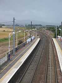
Prestonpans railway station
| Prestonpans | |
|---|---|
|
View along the tracks to a rainy Pentlands and the recent track deviation | |
| Location | |
| Place | Prestonpans |
| Local authority | East Lothian |
| Coordinates | 55°57′10″N 2°58′30″W / 55.9529°N 2.9750°WCoordinates: 55°57′10″N 2°58′30″W / 55.9529°N 2.9750°W |
| Grid reference | NT392737 |
| Operations | |
| Station code | PST |
| Managed by | ScotRail |
| Number of platforms | 2 |
|
Live arrivals/departures, station information and onward connections from National Rail Enquiries | |
| Annual rail passenger usage* | |
| 2004/05 | 0.108 million |
| 2005/06 |
|
| 2006/07 |
|
| 2007/08 |
|
| 2008/09 |
|
| 2009/10 |
|
| 2010/11 |
|
| 2011/12 |
|
| 2012/13 |
|
| History | |
| Original company | North British Railway |
| Post-grouping | LNER |
| National Rail – UK railway stations | |
| * Annual estimated passenger usage based on sales of tickets in stated financial year(s) which end or originate at Prestonpans from Office of Rail Regulation statistics. Methodology may vary year on year. | |
| UK Railways portal | |
Prestonpans railway station is a railway station serving the town of Prestonpans, East Lothian, Scotland. It is located on the North Berwick Line, 9.75 miles (15.69 km) east of Edinburgh Waverley. It serves the town of Cockenzie and Port Seton, 1.37 miles (2.20 km) away.
Services
Monday to Saturday daytimes there is a half-hourly service westbound to Edinburgh and eastbound to North Berwick. Evenings and Sundays there is an hourly service in each direction.
Routes
| Preceding station | |
Following station | ||
|---|---|---|---|---|
| Longniddry | ScotRail North Berwick Line |
Wallyford | ||
| Historical railways | ||||
| Seton Mains Halt[1] Line open; Station closed |
North British Railway NBR Main Line |
Inveresk Line open; Station closed | ||
References
Notes
- ↑ Smith & Anderson (1995), page 36
Sources
- Butt, R. V. J. (1995). The Directory of Railway Stations: details every public and private passenger station, halt, platform and stopping place, past and present (1st ed.). Sparkford: Patrick Stephens Ltd. ISBN 1-8526-0508-1. OCLC 60251199.
- Jowett, Alan (March 1989). Jowett's Railway Atlas of Great Britain and Ireland: From Pre-Grouping to the Present Day (1st ed.). Sparkford: Patrick Stephens Ltd. ISBN 1-8526-0086-1. OCLC 22311137.
- Smith, W.A.C. & Anderson, P. (1995) An Illustrated History of Edinburgh's Railways, Caernarfon, Irwell Press, ISBN 1-871608-59-7
- RAILSCOT on North British Railway
| Wikimedia Commons has media related to Prestonpans railway station. |
