Preston, East Riding of Yorkshire
Coordinates: 53°45′24″N 0°11′49″W / 53.756611°N 0.196915°W
Preston is a village and civil parish in the East Riding of Yorkshire, England, in an area known as Holderness. It is situated approximately 6 miles (9.7 km) east of Hull city centre it lies just north of the A1033 road on the crossroads between the B1240 and B1362 roads.
The civil parish is formed by the village of Preston and the hamlet of Salt End.
According to the 2011 UK census, Preston parish had a population of 3,258,[1] an increase on the 2001 UK census figure of 3,100.[2]

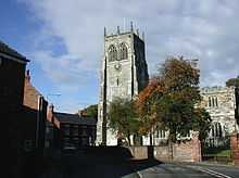
The parish church of All Saints is a Grade I listed building.[3]
There is both a primary school (Preston Primary School) and a secondary school, which achieved Technology College status almost a decade ago, and has a sixth form facility joined onto the school, in Preston. South Holderness Technology College serves the surrounding villages of Paull, Hedon, Bilton, Skirlaugh, Keyingham, Thorngumbald, Aldbrough, West Newton, Burton Constable, Sproatley and others.
Preston has three pubs, a pizza takeaway, a Chinese takeaway and a garden centre, with a farm shop. There is also a butcher's shop on the main street, along with the Post Office.
Recently 'Preston South' was marked clearly by the Council, however the two are not geographically all that close, and still stand as two separate areas separated in places by Hedon.
References
- ↑ 1.0 1.1 "Key Figures for 2011 Census: Key Statistics: Area: Preston CP (Parish)". Neighbourhood Statistics. Office for National Statistics. Retrieved 6 February 2013.
- ↑ "2001 Census: Key Statistics: Parish Headcounts: Area: Preston CP (Parish)". Neighbourhood Statistics. Office for National Statistics. Retrieved 19 May 2008.
- ↑ Historic England. "Church of All Saints (1083438)". National Heritage List for England. Retrieved 6 February 2013.
- Gazetteer — A–Z of Towns Villages and Hamlets. East Riding of Yorkshire Council. 2006. p. 9.
External links
| Wikimedia Commons has media related to Preston. |
