Prairie Township, Carroll County, Arkansas
| Prairie Township | |
|---|---|
| Township | |
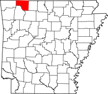
 Prairie Township Location in Arkansas | |
| Coordinates: 36°20′27.79″N 93°35′6.28″W / 36.3410528°N 93.5850778°WCoordinates: 36°20′27.79″N 93°35′6.28″W / 36.3410528°N 93.5850778°W | |
| Country |
|
| State |
|
| County | Carroll |
| Area | |
| • Total | 70.850 sq mi (183.50 km2) |
| • Land | 70.706 sq mi (183.13 km2) |
| • Water | 0.144 sq mi (0.37 km2) |
| Population (2010) | |
| • Total | 7,555 |
| • Density | 106.85/sq mi (41.26/km2) |
| Time zone | CST (UTC-6) |
| • Summer (DST) | CDT (UTC-5) |
| Zip Code | 72616 (Berryville) |
| Area code(s) | 870 |
Prairie Township is one of twenty-one current townships in Carroll County, Arkansas, USA.[1] As of the 2010 census, its total population was 7,555.
Geography
According to the United States Census Bureau, Prairie Township covers an area of 70.850 square miles (183.50 km2); 70.706 square miles (183.13 km2) of land and 0.144 square miles (0.37 km2) of water.
Cities, towns, villages, and CDPs
- Berryville (part)
References
- United States Census Bureau 2008 TIGER/Line Shapefiles
- United States Board on Geographic Names (GNIS)
- United States National Atlas
- ↑ "Prairie Township, Carroll County, Arkansas." U.S. Census Bureau. Breakdown. Retrieved June 8, 2012.
External links
| |||||||||||||||||||||||||||||||||||||