Praia do Norte
| Praia do Norte | |
| Civil Parish | |
 The overlook from Ribeira Funda, with the parish of Praia do Norte, and the coastal community of Fajã | |
| Official name: Freguesia da Praia do Norte | |
| Name origin: Portuguese for "north beach" | |
| Country | |
|---|---|
| Autonomous Region | |
| Island | Faial |
| Municipality | Horta |
| Localities | Cerca, Fajã, Praia do Norte |
| Rivers | Ribeira das Cabras, Ribeira do Adão, Ribeira do Bom Dia, Ribeira do Serrado Novo, Ribeira Funda |
| Center | Praia do Norte |
| - elevation | 191 m (627 ft) |
| - coordinates | 38°36′14″N 28°45′32″W / 38.60389°N 28.75889°WCoordinates: 38°36′14″N 28°45′32″W / 38.60389°N 28.75889°W |
| Highest point | Alto do Brejo |
| - location | Cabeço Gordo |
| - elevation | 926 m (3,038 ft) |
| - coordinates | 38°35′28″N 28°43′30″W / 38.59111°N 28.72500°W |
| Lowest point | Sea level |
| - location | Atlantic Ocean |
| - elevation | 0 m (0 ft) |
| Area | 13.85 km2 (5 sq mi) |
| - urban | .28 km2 (0 sq mi) |
| Population | 250 (2011) |
| Density | 18 / km2 (47 / sq mi) |
| Settlement | fl. 30 June 1567 |
| - Parish | fl. 1787 |
| - Civil Parish | 1 October 1845 |
| LAU | Junta Freguesia |
| - location | Largo da Igreja |
| President Junta | Estevão Gomes |
| President Assembleia | Tomás Américo Silveira Correia |
| Timezone | Azores (UTC-1) |
| - summer (DST) | Azores (UTC0) |
| Postal Zone | 9900-473 |
| Area Code & Prefix | (+351) 292 XXX-XXXX |
| Patron Saint | Nossa Senhora das Dores |
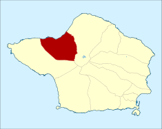 Location of the civil parish of Praia do Norte within the municipality of Horta
| |
| Wikimedia Commons: Praia do Norte | |
| Website: http://www.jf-praiadonorte.com | |
Praia do Norte is a civil parish of the municipality of Horta, located along the northern coast between Cedros and Capelo, on the island of Faial, Azores. The population in 2011 was 250,[1] in an area of 13.85 km².[2] It is the least populous parish on the island. It is reached by the E.R. 1-1ª Regional Road that circles the island.
Geography
The parish is part of the Capelo Volcanic Complex, a geologic area of layered ash and pyroclastic deposits produced less than 10,000 years ago. The rural town occupies the space along the Regional Road, while summer homes and some permanent residents occupy the "fajã" along the coast. Fajã is the term used to define a small extension of land, located along the ocean, formed from rock debris or a volcanic delta formed from lava meeting the ocean. The bay in Faja is naturally protected, resulting in a dark sand beach during the summer, although this area is generally known for its large waves throughout the year. The eastern portion of the parish is a tall and abrupt cliff that is connected to Cedros plateau.
History
This parish, and its church, were first referenced on June 30, 1567, for its fertile soil (which produced many of the islands cerals, beans and fruits). By 1643, there were 274 inhabitants and 77 homes in the area (as referenced by Diogo das Chagas). The parish at one time included the region of Capelo, but it was de-annexed.
The primitive parochial church was destroyed completely by the eruption of Cabeço do Fogo in 1672. At about one in the morning, a violent explosion awoke many of the residents, and forced them from their homes. Two lava flows escaped Cabeço do Fogo towards the north (Praia do Norte) and south (destroying the community of Ribeira do Cabo in Capelo). The northern flow, after pausing to destroy Lameiros, reached Praia do Norte where it covered the parish in black rock, covering the large tracts of arable land. Many of the residents of the northern coast abandoned the area, eventually resulting in the parish being incorporated into the neighboring parish (Capelo). According to Américo Costa (in Dicionário Corográfico) a large part of the inhabitants of both parishes (Capelo and Praia do Norte) were affected by the eruption; homes and farmlands in Ribeira do Cabo (Capelo), Lameiros and Praia do Norte were destroyed. A niche, located at the intersection to Norte Pequeno, currently marks the position of the old church. Some inhabitants returned gradually, planting vineyards and fruit trees and small agricultural farming developed on the higher elevations.
By the beginning of the 18th century 712 inhabitants lived in 180 buildings in the parish. In 1787, a chapel of Nossa Senhora de Penha de França was erected by the Madalena-native José Nunes da Silveira in Fajã da Praia. Another chapel, consecrated in the name of Nossa Senhora das Dores, was constructed in 1797.
Its civil parish status was returned on October 1, 1845, in its entirety. Celebrations marking these circumstances were only realized in 1845.
During the Capelinhos eruption (in 1957/58) the parish received collateral damage: the church of Nossa Senhora das Dores was destroyed completely. Similarly, many of the homes were also affected by the earthquakes associated with the eruptions, and the agricultural lands were, yet again, inundated with ash. A new modernist church was built in late 1961.
CP Valour and the Fajã Oil Spill
On December 9, 2005 while attempting to navigate to calm waters in the Bay of Praia do Fajã, the container vessel CP Valour, a Bermudan-registered ship, originally traveling between Montreal, Canada and Valencia, Spain, ran aground 300 m from the coast. It was transporting 800 containers, of which three were environmentally hazardous, and the vessel was filled with two thousand tons of fuel oil. The tugboats "São Luís" (from the port of Horta) and "São Miguel" (from the port of Ponta Delgada) were called out to assist the crippled vessel, and were later aided by the Russian tug "Fortiy Frilov" (in order to stabilize the ship in northerly swells). However, the bay's currents forced the ship further to shore, forcing the abandonment of the ship on 25 December. The hulls eventually breached, causing an oil spill into the bay and onto the beach at Fajã. Similarly, some containers containing toxic fire retardant, flammable ink and paint and sodium persulphate were affected, and several containers were damaged or destroyed during the incident, leaking their contents into the bay. In the report on the accident, the Marine Accident Investigation Branch noted several failures including lack of crew management and procedures on the part of the operator, the inexperience and lack of seamanship of the master, and lack of proper nautical charts and anchoring experience. The accident brought world attention to Fajã da Praia, Faial and the Azores.
Economy
Following the Cabeço do Fogo eruption, much of the lands in the parish were sterile and uncultivateable due to the ash. Gradually, agriculture returned to the area, although the region has been affected by the collapses in the wine, orange and potato crises during the 19-20th century. Cattle and dairy production are one of the two pillars of the economy today. The residents of the parish also rely on fishing, some boat construction and rock/sand extraction as basic sources of income. Although tourism is not an obvious cash stream, the area has unspoiled coastal areas, panoramic views towards Capelo (visible from Ribeira das Cabres) and high cliffs that attract or stop visitors regularly in the area.
Culture, tradition and tourism
The area is known for many of the same agricultural dishes emblematic of this region, including a pork stew, its wine (produced from the many rock vineyards of the Fajã) and a traditional corn flat-bread.
References
| ||||||||