Prague Metro
The Prague Metro is the rapid transit network of Prague, Czech Republic. Founded in 1974,[3] the Prague Metro now comprises three lines, serving 61 stations, and consists of a transit network 65.5 kilometres (40.7 mi) long.[1] It served 589.2 million passengers in 2012[2] (up from 530.5 million passengers in 2011[4]), making it the fifth busiest metro system in Europe and the most used in the world on a per capita basis. All the lines of Prague metro are controlled automatically from the central dispatching. The driver is only responsible for opening and closing doors.
Basic information
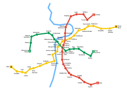
The Prague Metro has three lines, each represented by its own colour on the maps and signs: Line A (green), Line B (yellow) and Line C (red). There are 61 stations in total (three of which are transfer stations) connected by nearly 66 kilometres of mostly underground railways. The metro service operates from 4-5 am until midnight, with about two- to three-minute intervals between trains during rush hours. Over 580 million passengers use the Prague Metro every year.
The metro is run by the Prague Public Transit Company Co. Inc. (in Czech officially Dopravní podnik hlavního města Prahy a.s.) which manages all means of public transport around the city (the metro, tramways, buses, the funicular to Petřín Hill and the chairlift inside Prague Zoo). Since 1993, this system has been connected to commuter trains and buses and also to "park-and-ride" parking lots. Together they form a public transportation network reaching further from the city, called Prague Integrated Transport (Pražská integrovaná doprava—PID). Whilst the large system is zonally priced, the metro is entirely inside the central zone.
Many Prague Metro stations are quite large, with several entrances spaced relatively far apart. This can often lead to confusion for those unfamiliar with the system, especially at the central hubs such as Můstek or Muzeum: even at the right station, choosing the wrong way out to the surface often means being five or ten minutes' walking distance from one's destination. In general the stations are well signposted even for those unfamiliar with the Czech language.
System layout and stations

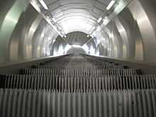
.jpg)
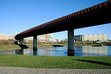
The Prague Metro system is laid out as a triangle, with all three lines meeting in the centre of the city at three interchange stations. Each interchange station has two halls, one hall for each line. The depth of the stations (and the connecting lines) varies considerably. The deepest station is Náměstí Míru, located 52 metres (171 ft) under the ground. Parts of the tracks in the city centre were mostly bored using the tunnelling shield. Outer parts were dug by the cut-and-cover method and the stations are only a few metres under the surface. Part of Line B runs in a glassed-in tunnel above the ground.
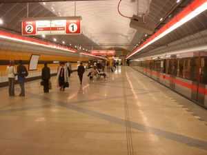
Most stations usually have a single island platform in the centre of the station hall (tunnel) serving both directions. The sub-surface stations have a straight ceiling sometimes supported by columns. The deep-level stations are larger tunnels with the track tunnels on each side. The walls of many stations are decorated using coloured aluminium panels; each station has its own colour.
| Line | Color | Opened | Year of last expansion |
Route | Length | Stations |
|---|---|---|---|---|---|---|
| Line A | Green | 1978[3] | 2015[5] | Nemocnice Motol ↔ Depo Hostivař[5] | 17.1 km (11 mi)[5] | 17[5] |
| Line B | Yellow | 1985[3] | 1998 | Zličín ↔ Černý Most | 25.6 km (16 mi)[6] | 24 |
| Line C | Red | 1974[3] | 2008 | Letňany ↔ Háje | 22.4 km (14 mi)[6] | 20 |
| Line D | Blue | ? | ? | Náměstí Míru ↔ Depo Písnice | 10.5 km (7 mi)[6] | 10 |
| TOTAL | 75.6 km (47.0 mi)[1] | 71[1] | ||||
Tickets
The Prague Metro operates on a proof-of-payment system. Passengers must buy and validate a ticket before entering a station's paid area. There are uniformed and plainclothes fare inspectors who can randomly check passengers' tickets within the paid area.
The tickets are the same for all means of transport in Prague (excluding commuter trains for single tickets). Basic single tickets cost 32 CZK (as of 1 May 2014) for a 90 minute ride or 24 CZK for a 30 minute ride. In November 2007 SMS purchase for basic single transfer tickets and day tickets was introduced.[7]
Short-term tourist passes are available for periods of 24 hours (110 CZK) and 3 days (310 CZK).
Longer-term season tickets can be bought on the smart ticketing system Opencard, for periods of one month (550 CZK), three months (1480 CZK) or the annual pass (4750 CZK).[8]
History

Although the Prague Metro system is relatively new, the idea of underground transport in Prague dates back many years. The first proposal to build a sub-surface railway was made by Ladislav Rott in 1898. He encouraged the city council to take the advantage of the fact that parts of the central city were already being dug up for sewer work. Rott wanted them to start digging tunnels for the railway at the same time. However, the plan was denied by the city authorities. Another proposal in 1926, by Bohumil Belada and Vladimír List, was the first to use the term "Metro", and though it was not accepted either, it served as an impulse for moving towards a real solution of the rapidly developing transport in Prague. In the 1930s and 1940s, intensive projection and planning works were being held, taking into account two possible solutions: an underground tramway (regular rolling stock going under ground in the city center, nowadays described as a "pre-metro") and a "true" metro having its own independent system of railways. After World War II, all work was stopped due to the poor economic situation of the country, although the three lines, A, B and C, had been almost fully designed.
In the early 1960s the concept of the sub-surface tramway was finally accepted and on 9 August 1967 the building of the first station (Hlavní nádraží) started. However, in the same year, a substantial change in the concept came, as the government, under the influence of Soviet advisers, decided to build a true metro system instead of an underground tramway. Thus, during the first years, the construction continued while the whole project was conceptually transformed. Regular service on the first section of Line C began on 9 May 1974 between Sokolovská (now Florenc) and Kačerov stations.[3] Building continued quite rapidly after that. In 1978 the first section of Line A was opened and, finally, line B opened in 1985, thus forming the triangle with three crossing points. Since then, the lines have been extended outwards from the center. Line B was extended from Nové Butovice to Zličín in 1994 and from Českomoravská to Černý Most in 1998. Kolbenova and Hloubětín stations were opened in 2001.
On 22 February 1990, 11 station names reflecting communist ideology were changed to be politically neutral. Leninova station, which contained a giant bust of Lenin before the Velvet Revolution, was renamed Dejvická after a nearby street and surrounding neighbourhood.

In August 2002, the metro suffered disastrous flooding that struck parts of Bohemia and other areas in Central Europe (see 2002 European flood). 19 stations were flooded, causing a partial collapse of the transport system in Prague; the damage to the metro has been estimated at approximately 7 billion CZK (over US$200 million). The affected sections of the metro stayed out of service for several months; the last station (Křižíkova, located in the most-damaged area - Karlín) reopened in March 2003. Small gold plates have been placed at some stations to show the highest water level of the flood. Trains terminated at:
- Radlická and returned to Zličín B
- Kolbenova and returned to Černý Most B
- Malostranská and returned to Dejvická A
- Náměstí Míru and returned to Skalka A (before the Depo Hostivař extension)
- Hlavní nádraží and returned to Haje C
The service was suspended between:
- Radlická and Kolbenova on Line B
- Malostranská and Náměstí Míru on Line A
- Hlavní nádraží and Nádraží Holešovice on Line C (before the extension to Ládví in 2004 and to Letňany in 2008)
A northern extension of Line C was opened on 26 June 2004, with two more stations, Kobylisy and Ládví. Notable is the way that new tunnels were built under the Vltava river. A unique "ejecting-tunnels" technology was chosen for this. First, a trench was excavated in the riverbed and the concrete tunnels constructed in dry docks on the riverbank. Then the docks were flooded, and the floating tunnels were moved as a rigid complex to their final position, sunk, anchored and covered.[9]
Line A was extended to the east in the 2000s. On 26 May 2006, a new terminus, Depo Hostivař, opened. The station was constructed within the buildings of an existing railway depot. The extension is the first segment of the system to be built above ground and not through a tunnel.
Line C was extended to the northeast to connect the city center to the large housing blocks at Prosek. Three stations (Střížkov, Prosek and Letňany) opened on 8 May 2008.
A number of stations were closed due to the flooding in June 2013.[10] Replacement buses ran between Dejvická and Muzeum on line A, Českomoravská and Smíchovské nádraží on line B and Kobylisy and Muzeum on line C due to closed sections of the track.[11]
Rolling stock


Service is currently provided entirely with five-car units. There are two kinds of units currently in operation on the Prague Metro:
- M1, serving on line C since 1998, completely replaced older cars on line C in 2003. The metro owns 52 units. These units were manufactured in Prague by consortium consisting of ČKD Praha, ADtranz and Siemens (during the contract Siemens acquired ČKD Praha). This unit was also adapted for use in Venezuela on the Maracaibo Metro.
- 81-71M, completly modernized variant with new motor of the old Soviet 81-71 trains serving on the line A and on line B. First modernization was completed in 1996 and they are still continuing since in Škoda Transportation. Similar reconstructions were also made in the Tbilisi metro and Yerevan metro.
Previously in service:
- 81-71, old Soviet trains manufactured by Metrovagonmash serving only on line B, being gradually phased out and replaced by the modernized versions. Their service ended on 2 July 2009. Note that the original type designation discerned between cab (81-717) and cabless (81-714) cars, while Czech did not, referring to a whole trainset consisting of both 717 and 714 type cars.
- Ečs, Soviet trains manufactured by Metrovagonmash, that ran on line C, in service from 1974-1997.
Features
"Můstek" means "little bridge" and refers to the area around the Můstek station. The origin of the area's name was not known until remains of a medieval bridge were discovered during construction of the station. The remains were incorporated into the station and can be seen near the northwestern exit of the station.
The escalator at Náměstí Míru station in Vinohrady is about 100 metres long and, according to its builder, is the longest escalator in Europe.[12] It takes about two and a half minutes to ascend or descend the escalator if you stand still.
Between I. P. Pavlova and Vyšehrad stations, Line C runs inside the box structure of the Nusle Bridge over a steep valley.
Anděl station was known as Moskevská (Moscow Station) until 1990. It opened on the same day in 1985 as the Prazhskaya (Prague) station on the Moscow Metro. It contains several pieces of propaganda art promoting Soviet-Czechoslovak friendship. Anděl station, like the Smíchov train station, contains some of the best-preserved examples of Communist-era propaganda art remaining in Prague.
During the communist period rumors circulated that large "survival chambers" were being built for high officials of the government in the case of a nuclear attack. After the fall of communism such areas were shown indeed to exist, but not on the scale envisioned nor fitted out in luxury.
Future plans
The first phase of a CZK18.7 milliards extension on the west end of the A line, from Dejvická to Nemocnice Motol, was opened to the public on the afternoon of 6 April 2015.[13] The second phase of this extension will see the line reach Václav Havel Airport and is set to open by 2021.[14] Before this, a railway connection to the airport will be opened.
| Planned line | Name | Note |
|---|---|---|
| Line D | Line D (Linka D) | Proposal will connect the city centre to its southern parts |
There are further plans to build a new line, Line D (or blue line). Line D would connect the city centre to southern parts of the city. According to the newest plans, the line will run along the same tracks as Line C from Nádraží Holešovice to Pankrác station, before branching down a new line to Krč, Libuš and Písnice. The seven planned stations on the line are currently named Olbrachtova, Nádraží Krč, Nemocnice Krč, Nové Dvory, Libuš, Písnice and Depo Písnice. The construction may start in 2015.[15]
Culture
The announcement made through the public address system when the doors are closing, Ukončete, prosím, výstup a nástup, dveře se zavírají ("Please finish exiting and boarding, the doors are closing") has become a symbol of Prague for some tourists, and is possibly the first clear Czech phrase many travelers hear.
See also
References
- ↑ 1.0 1.1 1.2 1.3 1.4 1.5 "Company Profile - Dopravní podnik hlavnívo města Prahy". Dopravní podnik hlavnívo města Prahy. Retrieved 2015-04-06.
- ↑ 2.0 2.1 "Annual Report 2012" (PDF). DPP.cz (via: http://www.dpp.cz/en/annual-reports/)''. Dopravní podnik hlavnívo města Prahy. 2012. p. 66. Retrieved 2013-09-20.
- ↑ 3.0 3.1 3.2 3.3 3.4 3.5 "History - Dopravní podnik hlavnívo města Prahy". Dopravní podnik hlavnívo města Prahy. Retrieved 2013-09-11.
- ↑ "Annual Report 2011" (PDF). DPP.cz (via: http://www.dpp.cz/en/annual-reports/)''. Dopravní podnik hlavnívo města Prahy. 2011. p. 75. Retrieved 2013-09-20.
- ↑ 5.0 5.1 5.2 5.3 Tomáš Rejdal. "Linka A". metroweb.cz (in Czech). Retrieved 2015-04-06.
- ↑ 6.0 6.1 6.2 "Metro". Praha.eu. Retrieved 2014-01-18.
- ↑ "Novelty on Prague transport system: tickets by SMS". Radio Prague. 22 November 2007. Retrieved 2014-01-07.
- ↑ "Jízdné na území Prahy" (in Czech). Dopravní podnik hlavnívo města Prahy. Retrieved 2013-10-24.
- ↑ "Metrostav | Projects". Metrostav.cz. Retrieved 2013-10-24.
- ↑ "Prague authorities close metro stations amidst fears of flooding". Radio Prague. 2 June 2013. Retrieved 2014-01-07.
- ↑ "Another 4 metro stations closed over floods in Prague". Prague Monitor. 4 June 2013. Retrieved 2014-01-07.
- ↑ "Company". ThyssenKrupp Elevator. Retrieved 2013-10-24.
- ↑ http://www.dpp.cz/en/permanent-changes-to-the-pit-system-as-of-the-7th-april-2015/
- ↑ "Work starts on Praha metro extension". Railway Gazette International. 4 May 2010. Retrieved 2013-10-24.
- ↑ "Dopravní výbor kývl na zkrácenou podobu metra D, levnější o 10 miliard - iDNES.cz". Praha.idnes.cz. Retrieved 2013-10-24.
External links
| Wikimedia Commons has media related to Prague Metro. |
- Prague Public Transit Co. Inc. –official site including maps, fare information, etc.
- DP-Praha Fares (English)
- www.metroweb.cz – pages of Czech metrophiles with plenty of information and pictures (in Czech, with some information available in English)
- Floods in Prague Metro 2002 - photogallery
- Architecture photo series of all stations of the Prague Metro
| ← direction Nemocnice Motol | Prague Metro – line A | direction Depo Hostivař → |
| Metro stops on this line | ||
| Nemocnice Motol | ||
| ← direction Zličín | Prague Metro – line B | direction Černý Most → |
| Metro stops on this line | ||
| Zličín | ||
| ← direction Letňany | Prague Metro – line C | direction Háje → |
| Metro stops on this line | ||
| Letňany | ||
| ||||||||||
| ||||||