Pothumarru
| Avanigadda అవనిగడ్డ | |
|---|---|
| Village | |
|
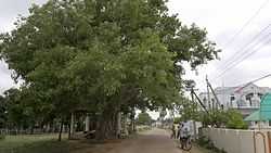
A 300 year old Holy Fig tree Pothumarru village | |
 Avanigadda Location in Andhra Pradesh, India | |
| Coordinates: 16°1′11″N 80°55′12″E / 16.01972°N 80.92000°ECoordinates: 16°1′11″N 80°55′12″E / 16.01972°N 80.92000°E | |
| Country | India |
| State | Andhra Pradesh |
| District | Krishna |
| Government | |
| • Type | Democratic |
| • Body | Panchayatraj |
| Elevation | 57 m (187 ft) |
| Population (2011)[1] | |
| • Total | 23,737 |
| Languages | |
| • Official | Telugu |
| Time zone | IST (UTC+5:30) |
| Area code(s) | +91-8671 |
| Lok Sabha constituency | Machilipatnam |
Pothumarru is a village in Kalidindi mandal, located in Krishna district of the Indian state of Andhra Pradesh. Pothumarru is located at 16°31'46"N 81°18'46"E.
References
- ↑ "Census 2011". The Registrar General & Census Commissioner, India. Retrieved 25 July 2014.