Portolan chart

Portolan or portulan charts are navigational maps based on compass directions and estimated distances observed by the pilots at sea. They were first made in the 13th century in Italy, and later in Spain and Portugal, with later 15th and 16th century charts noted for their cartographic accuracy.[1] With the advent of widespread competition among seagoing nations during the Age of Discovery, Portugal and Spain considered such maps to be state secrets. The English and Dutch relative newcomers found the description of Atlantic and Indian coastlines extremely valuable for their raiding, and later trading, ships. The word portolan comes from the Italian adjective portolano, meaning "related to ports or harbors", or "a collection of sailing directions".[1]
Contents and themes
These charts, actually rough maps, were based on accounts by medieval Europeans who sailed the Mediterranean and Black Sea coasts. Such charts were later drafted for coastal resources in the Atlantic and Indian oceans. At the beginning of the Age of Discovery, charts had been made for the coast of Africa, Brazil, India, and past the Strait of Malacca into Japan, knowledge vital for the slow rise to prominence of the English Armada and of Dutch merchants, following in the wake of the Iberian powers. Frequently drawn on sheepskin vellum, portolan charts show coastal features and ports.[1] During that period, smaller ships could use more of the coastline as harbours than in the present era. They might need to seek refuge more often, and crews intentionally beached some ships for maintenance and repairs. Thus, mariners sought to learn of protected bays or flat beaches, not only for safe harbour but also for coastal navigation.
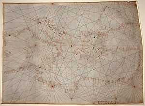
The straight lines shown criss-crossing many portolan charts represent the thirty-two directions (or headings) of the mariner's compass from a given point, with its principal lines oriented to the magnetic north pole.[1] Thus the grid lines varied slightly for charts produced in different eras, due to the natural changes of the Earth's magnetic declination.[1] These lines are similar to the compass rose displayed on later maps and charts. "All portolan charts have wind roses, though not necessarily complete with the full thirty-two points; the compass rose ... seems to have been a Catalan innovation."[2]
The portolan combined the exact notations of the text of the periplus or pilot book with the decorative illustrations of a medieval T and O map. In addition, the charts provided realistic depictions of shores. They were meant for practical use by mariners of the period. Portolans failed to take into account the curvature of the earth; as a result, they were not helpful as navigational tools for crossing the open ocean, being replaced by later Mercator projection charts.[1] Portolans were most useful in close quarters' identification of landmarks.[1] Portolani were also useful for navigation in smaller bodies of water, such as the Mediterranean, Black, or Red Seas.
History
The oldest extant portolan is the Carta Pisana, dating from approximately 1296. The cartographer Angelino Dulcert produced a portolan in 1339.
See also
References
Citations
- ↑ 1.0 1.1 1.2 1.3 1.4 1.5 1.6 Rehmeyer, Julie. The Mapmaker's Mystery, Discover, June 2014, pp. 44–49 (subscription).
- ↑ Tony Campbell, "Portolan Charts from the Late Thirteenth Century to 1500", Chapter 19 of The History of Cartography, Volume I. U. of Chicago Press, 74th edition (May 15, 1987), p. 395.
Bibliography
- Francesco Maria Levanto, Prima Parte dello Specchio del Mare, Genova, G.Marino e B.Celle, 1664. Disponibile anche in ristampa anastatica dell'edizione originale, Galatina, Congedo, 2002. (Italian)
- Konrad Kretschmer, Die italianischen Portolane des Mittelalters, Ein Beitrage zur Geschichte der Kartographie und Nautik, Berlin, Veroffentlichungen des Institut fur Meereskunde und des Geographischen Instituts an der Universitat Berlin, Vol. 13, 1909. (German)
- Bacchisio Raimondo Motzo, Il Compasso da Navigare, Opera italiana della metà del secolo XIII, Cagliari, Annali della facoltà di lettere e filosofia dell'Università di Cagliari, VIII, 1947. (Italian)
- Patrick Gautier Dalché, Carte marine et portulan au XIIe siècle. Le Liber de existencia rivieriarum et forma maris nostri Mediterranei, Pise, circa 1200, Roma, École Française de Rome, 1995. (French)
- Tony Campbell, "Portolan Charts from the Late Thirteenth Century to 1500", Chapter 19 of The History of Cartography, Volume I. U. of Chicago Press, 74th edition (May 15, 1987).
External links
| Wikimedia Commons has media related to Portolan charts. |
- Portolan Charts mini-site, University of Minnesota
- Portolan Charts, Samples of portolan charts illustrating the harbors and trade routes of the Mediterranean, 14th–16th centuries, from the Beinecke Rare Book and Manuscript Library, Yale University
- J. Rey Pastor & E. Garcia Camarero La cartografía mallorquina (Spanish)
- Portolan Charts butronmaker
- BigThink: Portolan Charts 'Too Accurate' to be Medieval