Porto Rafti
| Porto Rafti Πόρτο Ράφτη | |
|---|---|
|
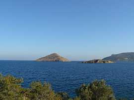
View of Raftis Island and Raftopoula | |
 Porto Rafti | |
|
Location within the region | |
| Coordinates: 37°51′N 24°01′E / 37.850°N 24.017°ECoordinates: 37°51′N 24°01′E / 37.850°N 24.017°E | |
| Country | Greece |
| Administrative region | Attica |
| Regional unit | East Attica |
| Municipality | Markopoulo Mesogaias |
| Elevation | 5 m (16 ft) |
| Population (2011)[1] | |
| • Rural | 9,686 |
| Time zone | EET (UTC+2) |
| • Summer (DST) | EEST (UTC+3) |
| Postal code | 190 03 |
| Area code(s) | 22990 |
| Vehicle registration | Z |
Porto Rafti (Greek: Πόρτο Ράφτη), official name: Limin Markopoulou (Greek: Λιμήν Μαρκοπούλου), is a seaside resort town in East Attica, Greece. It is part of the municipality Markopoulo Mesogaias. In 2011, its population was 9,686.
Geography
Porto Rafti is situated on the Rafti Bay, a bay of the Aegean Sea, on the east coast of the Attica peninsula. It is surrounded by hills, the tallest of which is Merenta, 613 m above sea level. It is 5 km south of Vravrona, 6 km east of Markopoulo and 26 km southeast of the center of Athens.
History
The port was a major trading place until the collapse of the Roman Empire. The names of the ancient villages were Prasiai, Steiria and Koroni. They belonged to the Pandionis phyle according to the division of Ancient Athens Democracy made by Clisthenes in the early 5th century BC. The port of Porto Rafti is no longer in use due to environmental concerns. This port was the scene of the allied troops' evacuation after the German invasion in Greece at the end of April 1941.
Historic population
| Year | Population |
|---|---|
| 1991 | 3,292 |
| 2001 | 7,131 |
| 2011 | 9,686 |
References
- ↑ "Detailed census results 2011" (in Greek).
External links
| Wikimedia Commons has media related to Porto Rafti. |
| ||||||