Portezuelo, Chile
| Portezuelo | |
|---|---|
| Commune | |
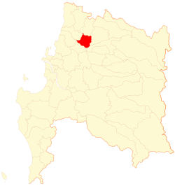
 Map of Portezuelo commune in the Biobío Region | |
 Portezuelo Location in Chile | |
| Coordinates: 36°32′S 72°26′W / 36.533°S 72.433°WCoordinates: 36°32′S 72°26′W / 36.533°S 72.433°W | |
| Country | Chile |
| Region | Biobío |
| Province | Ñuble |
| Government[1] | |
| • Type | Municipality |
| • Alcalde | Modesto Sepúlveda Andrade (PDC) |
| Area[2] | |
| • Total | 282.3 km2 (109.0 sq mi) |
| Elevation | 132 m (433 ft) |
| Population (2012 Census)[2] | |
| • Total | 4,903 |
| • Density | 17/km2 (45/sq mi) |
| • Urban | 1,750 |
| • Rural | 3,720 |
| Sex[2] | |
| • Men | 2,825 |
| • Women | 2,645 |
| Time zone | CLT [3] (UTC-4) |
| • Summer (DST) | CLST [4] (UTC-3) |
| Area code(s) | 56 + 42 |
| Website | Municipality of Portezuelo |
Portezuelo (Spanish pronunciation: [porteˈswelo]) is a Chilean town and commune located in the Ñuble Province, Biobío Region.
Demographics
According to the 2002 census of the National Statistics Institute, Portezuelo spans an area of 282.3 km2 (109 sq mi) and has 5,470 inhabitants (2,825 men and 2,645 women). Of these, 1,750 (32%) lived in urban areas and 3,720 (68%) in rural areas. The population fell by 8.4% (500 persons) between the 1992 and 2002 censuses.[2]
Administration
As a commune, Portezuelo is a third-level administrative division of Chile administered by a communal council, headed by an alcalde who is directly elected every four years. The 2008-2012 alcalde is Modesto Sepúlveda Andrade (PDC). The communal council has the following members:[1]
- Paulina Zamudio (Ind./Pro-PDC)
- Daniel Pastén (UDI)
- Pedro Fernández (Ind./PDC)
- Flavio Barrientos (Ind./RN)
- Marcelo Cortés (PRI)
- Melitón Aravena (PDC)
Within the electoral divisions of Chile, Portezuel belongs to the 42nd electoral district and 12th senatorial constituency.
See also
References
- ↑ 1.0 1.1 "Municipality of Portezuelo" (in Spanish). Retrieved 28 July 2010.
- ↑ 2.0 2.1 2.2 2.3 "National Statistics Institute" (in Spanish). Retrieved 28 July 2010.
- ↑ "Chile Time". WorldTimeZones.org. Retrieved 2010-07-28.
- ↑ "Chile Summer Time". WorldTimeZones.org. Retrieved 2010-07-28.
External links
- (Spanish) Municipality of Portezuelo
| ||||||||||||||||||||
