Port of Hull
| Port of Hull | |
|---|---|
|
The P&O Ferries terminal at the Port of Hull | |
| Location | |
| Country | England |
| Location | Kingston upon Hull |
| Coordinates | 53°44′17″N 0°19′55″W / 53.738°N 0.332°WCoordinates: 53°44′17″N 0°19′55″W / 53.738°N 0.332°W |
| Details | |
| Operated by | Associated British Ports |
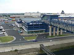
The Port of Hull is a trading port located at the confluence of the River Hull and the Humber Estuary in the city of Kingston upon Hull in the East Riding of Yorkshire, England. Seaborne trade can be traced to at least the 13th century.[1] As of 2010 the main port is operated by Associated British Ports and is estimated to handle one million passengers per year and is the main softwood timber importation port for the UK.[2] The Port of Hull is a constituent port of the Hull and Humber Ports City Region.
History
Background
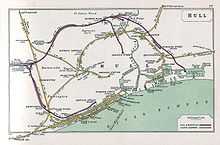
Hull lies at a naturally advantageous position for a port, on the north side of the Humber Estuary to the west of a bend southwards giving rise to (on average) deeper water; and the River Hull flows out into the Humber at the same point.[3][map 1]
An important event in the history of Hull as a port was its acquisition by king (Edward I). In 1297, it then became the only port from which goods could be exported overseas from the county of Yorkshire.[4] Thus in the 13th and 14th centuries Hull was a major English port for the export of wool,[note 1] much of it to Flanders, with wine being a major import.[5][note 2] During this period the River Hull was made navigable as far as the then important town of Beverley (1269), and roads built connecting Hull to Beverley and Holderness and to the via regia between Hessle and Beverley near to Anlaby (about 1302).[4]
By the 15th century trade with the Hanseatic league had become important and in the same period the growth of the English cloth industry meant that the export of cloth from Hull increased whilst wool exports decreased.[6] The 16th century brought a considerable reduction in the amount of cloth traded through the port, but the export of lead increased.[7] By the late 17th century Hull was the third port in the realm after London and Bristol, with export of lead and cloth, and imports of flax and hemp as well as iron and tar from the Baltic.[8]
Until 1773 trade was conducted via the Old Harbour, also known as The Haven, a series of wharves on the west bank of the River Hull,[note 3] with warehouses and the merchants' houses backing on to the wharves along the High Street.[note 4]
Hull Dock Company
By the 18th century it was becoming increasingly clear that the Haven was unfit for the increasing amount of trade: it was not only narrow, but tidal and prone to a buildup of mud from the estuary.[10][11] An additional stimulus to change was the demand for a 'legal quay' on which customs officials could easily examine and weigh goods for export without causing excessive delay to shipment.[12]
In 1773 the Hull Corporation, Hull Trinity House and Hull merchants formed the "Dock Company",[11] which was the first statutory dock company in Britain.[13] The Crown gave the land which contained Hull's city walls for construction of docks,[14] and an act of Parliament was passed in 1774 allowing the Dock Company to raise up to £100,000 by shares and loans; thus Hull's first dock (the Old Dock) ( a wet dock) began construction.[10][11] Three docks (known as the Town Docks) which followed the path of the town walls were constructed by the company between 1778 and 1829: The Old Dock (later Queen's Dock) (1778), Humber Dock (1809), and Junction Dock (later Prince's Dock) (1829).[15][16][17] An extension of the Town Docks (Railway Dock) was built in 1846 just north of the terminus of the then recently opened Hull and Selby Railway.[15] The first dock in Hull east of the River Hull (Victoria Dock) was constructed between 1845 and 1850; this became the main dock for timber trade, and was expanded in the next two decades including the construction of large timber ponds.[18]
In 1860 a rival company, the West Dock Company, was formed to promote and build new docks suitable for the increasing amounts of trade and the increasing size of steam ships; the scheme was supported by the Hull Corporation, Trinity House, the North Eastern Railway (NER) and various individuals in Hull. The site for the proposed dock was on the Humber foreshore to the west of the River Hull. The Dock Company then proposed a larger dock at the same position, which was sanctioned by an Act of Parliament in 1861[note 5][20] This dock was known as "the Western Dock" until its opening in 1869 when it was named "Albert Dock"; an extension "William Wright Dock" was opened 1880.[19] A third dock (St. Andrew's Dock) on the Humber foreshore west of the William Wright Dock was opened in 1883.[21] All three docks where ideally suited for trans-shipment by rail as they were directly south of and parallel with the Selby to Hull railway line that terminated in the centre of Hull.
In 1885 Alexandra Dock opened, which was owned and operated by the Hull Barnsley & West Riding Junction Railway and Dock Company. This ended the Dock Company's monopoly on dock facilities in Hull and led to price cutting competition between the two companies for dock charges; the Dock Company was operating at a loss and from 1886 sought to merge the company into a larger organisation – the obvious choice being the North Eastern Railway.[22] In 1891 the Dock Company approached the North Eastern for capital to improve its Albert Dock, leading to the North Eastern Railway acquiring the shares and debts of the Dock Company in exchange for its shares. Instead of improving the Albert Dock, the North Eastern decided to expend a much greater sum on a new dock, east of the Alexandra Dock; however the proposal was opposed by both the Hull and Barnsley, and the Hull Corporation. The Dock Company and NER were legally amalgamated in 1893; one of the clauses of the Act of Parliament allowing the merger stipulated that about £500,000 would be spent on dock improvements over the next seven years.[23]
Clauses in the 1893 amalgamation bill protecting the Hull and Barnsley company prevented the NER from creating a new deep water dock without consulting the H&BR. This led to a joint proposal for a dock east of Alexandra Dock being submitted, and passed in 1899, as the "Hull Joint Dock Act".[24] The new dock was opened in 1914 as the King George Dock.[25]
Dock ownership (1922–)
The Hull and Barnsley Railway became part of the North Eastern Railway in 1922,[26] making the docks in Hull the responsibility of a single company once again. The Railways Act 1921 led to the merger of the NER into the London and North Eastern Railway in 1923.[26] In 1948 much of Britain's transport operations were nationalised by the Transport Act 1947 into the British Transport Commission, including the port and railway operations of the LNER. In 1962 the British Transport Docks Board was formed by the Transport Act 1962. In 1981 the company was privatised by the Transport Act 1981, and Associated British Ports was formed.
Docks
The Town Docks
The Old Dock
The first dock in Hull, was built between 1775 and 1778 to a design by Henry Berry and John Grundy; Luke Holt acted as resident engineer, appointed on John Smeaton's recommendation.[27] The dock was called The Dock until the construction of further docks,[28] whence it was called The Old Dock,[29] it was officially named the Queen's Dock in 1855.[note 6][note 7]
The dock entrance was on the River Hull just south of North Bridge,[map 2] and the dock itself built west-south-west along the path of the North Wall as far as the Beverley Gate.[note 8] Some of the work proved inadequate, requiring reconstruction later.[10] The dock walls were of local brick, whilst cement for its construction was rendered waterproof through the use of pozzolana imported from Italy. At the entrance to the dock a double drawbridge, counterbalanced for ease of use, of the Dutch, type allowed people to cross the lock.[10]
The dock was 1,703 ft (519 m) long, 254 ft (77 m) wide, and the lock 121 ft (37 m) long and 38 ft (12 m) wide, with the depth of water being between 15 and 20 ft (4.6 and 6.1 m) depending on the tide.[32][map 3]
The dock closed in 1930 and was sold to the Corporation for £100,000, subsequently it was infilled and converted to an ornamental gardens known as Queen's Gardens.[33][34]
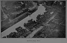
Humber Dock
_-_geograph.org.uk_-_917371.jpg)
Since the entrance to the Old Dock was via the River Hull there were still problems with ships accessing the dock through the crowded river; in 1781 a canal was proposed to connect the Old Dock to the Humber, additionally sea-borne trade was still in general increasing. There was some delay in making a solution, partly due to lethargy of the Dock Company, but, by 1802 a bill had been passed in Parliament for the construction of a second dock; again following the path of the City walls, this time from Hessle gate roughly northwards.[35]
John Rennie and William Chapman were employed as engineers,[36][37] John Harrap was the on site engineer.[38][39] Construction started in 1803 and was completed in 1809 at a cost of £220,000;[40] mud from the excavations was used to make new ground on the banks of the Humber.[note 9]
The dock entrance was from the Humber via an outer basin with piers.[map 4] The dock itself was 914 ft (279 m) long and 342 ft (104 m) wide, the lock was 158 ft (48 m) long and 42 ft (13 m) wide. The depth of water varied from 21 to 26 ft (6.4 to 7.9 m) seasonally depending on the tides.[40][map 5]
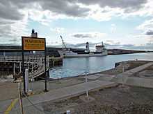
Humber Dock closed in 1968, it re-opened in 1983 as the Hull Marina.[39]
Junction Dock

One stipulation of the Act of 1802 for the construction of Humber Dock was that, when the average tonnage of goods unloaded at the docks reached a certain level, the Dock Company would build a third dock between the Old and Humber docks. This continuation was satisfied in 1825, the Act of Parliament required had already been passed in 1824, and construction of the third dock began in 1826.[43]
This dock, Junction Dock was constructed between, and connected the Old and Humber docks; making the old town of Hull an island bounded by the three docks,[29] river and estuary; it was designed by James Walker with John Timperley as resident engineer[44] and built roughly along the lines of the old fortifications between Beverley and Myton gates.[45] The construction cost £186,000.[46]
The dock opened in 1829 and was 645 ft (197 m) long and 407 ft (124 m) wide, with a lock at each end 36 ft (11 m) wide with a bridge over each.[47] In 1855 it was renamed Prince's Dock.[note 6][map 6]
The dock closed in 1968,[48] part of the dock still exists, but without a lock connection to Humber Dock; the Princes Quay shopping centre opened in 1991[48] was built over part of the dock on stilts, the dock now features a fountain.[49]
Railway Dock
The dock company applied to build a new branch dock in May 1844,[50] and obtained powers with the Kingston-upon-Hull Dock Act, 1844, which also enable the construction of an east dock (later Victoria Dock). In late 1844 the company applied to expand the branch dock,[51] which was enabled by the Kingston-upon-Hull Dock Act, 1845.
The Railway Dock was connected on the west side of Junction Dock to the north of Kingston Street, and was smaller than the other town docks. The dock of 13,130 sq ft (1,220 m2),[map 7] approximately 716 by 165 feet (218 by 50 m) was constructed at a cost of £106,000. The dock opened 3 December 1846.[52][53] The Dock company's engineer was J.B Hartley; also engineer on the east dock.[54]
Its primary purpose was for the transfer of goods to and from the newly built Hull and Selby Railway,[15] which had its passenger terminus just west of Humber Dock facing onto Railway Street, and its goods sheds north of this (see Manor House Street station). Railway lines also ran from the goods shed to the Humber Dock.[55]
Like Humber Dock the dock closed in 1968 and in 1984 became part of the Hull Marina.[56]
Victoria Dock
.jpg)
After the construction of the Junction Dock in 1825 the port and its trade continued to grow substantially leading to a requirement for a new dock.[57] In 1838 an independent company, the Queen's Dock Company, was formed to promote a new dock. The new dock, of around 12 acres (4.9 ha), to be called the Queen's Dock,[note 7] was designed by James Oldham for a site of around 30 acres (12 ha) in Drypool east of the River Hull and The Citadel and near to the river's confluence with the Humber. The proposed dock had entrances onto the Humber, and onto the Hull. Capital of £180,000 was proposed for the scheme.[52][58] Proceedings for a bill in parliament were begun in 1838.[59][note 10]
The Queen's Dock company abandoned the project, after the Dock Company took up a similar proposal.[60] In September 1839 the James Walker was requested to make plans for a dock,[61] and proceedings for a bill in parliament were begin in the end of that year.[62] The dock's main aim was to accommodate the increased timber trade, freeing up the town docks;[63] alternative plans were also considered including a west dock, and the conversion of the Old Harbour (River Hull) into a dock.[64] Walker's dock was broadly similar to the built dock,[note 11] with entrances onto both the Humber and river;[note 12] the design also admitted extension to the east with timber ponds at a later date.[65]
The 1840 bill was withdrawn due to local opposition. In 1844/4 the company returned to parliament again with a bill for a dock in the same location, as well as other works including the Railway Dock.[57][68] Permission to build the new east dock, and railway dock was granted in 1844; construction of this new dock began in 1845 and was completed in 1850 at a cost of £300,000.[69] The Dock company's engineer for the dock was J.B Hartley; the plan was similar in overall form to that of James Walker's design.[54] The formal laying of the foundation stone took place 5 November 1845, and the formal opening on 3 July 1850, with the dock given the name Victoria Dock, in honour of the then Queen, Victoria I.[52]
The dock had an area of about 12.83 acres (51,900 m2), with the Half-tide basin 3 acres (12,000 m2), the outer basin onto the Humber 2.75 acres (11,100 m2), and the Drypool basin 1.125 acres (0.455 ha).[note 13] In some respects the dock was of a slightly larger design that Walker's 1840 proposal: water depth was 27.5 to 22 feet (8.4 to 6.7 m) (spring to neap tide), and the entrances onto the Humber and River were 60 and 45 feet (18 and 14 m) wide respectively.[70] There were two entrances: the larger entrance was onto the Humber; from an outer basin it led via two parallel locks to the Half Tide Basin,[note 14][map 8] and then to the dock itself.[map 9] The second entrance was onto the River Hull south of the entrance to the Old Dock and of Drypool Bridge; it had an outer lock which opened directly to a second locked area known as Drypool Basin.[map 10][note 15] The first timber pond was added soon after the construction of the dock.[72]
In 1845 the York, Hull and East and West Yorkshire Junction Railway had proposed a railway line from York to Hull which was to terminate at the East Dock; as a consequence the York and North Midland Railway (Y&NMR) was forced to bring forward its own scheme to connect the east dock to the railway network.[73][74] The Y&NMR's Victoria Dock Branch Line was opened in 1853.
In 1863 the dock itself was expanded eastwards by 8 acres (3.2 ha), plus another timber pond (No.2) of 12 acres (4.9 ha) east of the dock, whilst the original timber pond (No.1) east of the half-tide basin was extended through land reclaimed from the Humber.[69] In 1875 the extent of the two ponds was 14 and 8 acres (57,000 and 32,000 m2) respectively.[70]
The western boundary of the dock was defined by the Hull Citadel, which was sold to the Dock company and demolished in 1864, the site was then used for timber storage,[18] Part of the former Citadel land was used by Martin Samuelson and Company (later Humber Iron Works) for shipbuilding,[75] later by Cook, Welton & Gemmell (from 1883 to 1902).[76][77] C. & W. Earle also had shipbuilding facilities (established 1851) on the banks of the Humber adjacent to and south of Victoria Dock.[78]
Part of the northwest corner of the eastern timber pond (No.2) was filled in c. 1900 due to changes to the railway layout north of the dock, by the second half of the 20th century both ponds had been filled in creating timber yards and sidings;[79] this pattern of use was retained until closure.[80] One major use of the dock was for the trade in timber, there were also facilities for cattle import including abattoirs and cold stores, coal was also exported through the dock.[81]
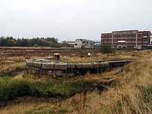
The Dock closed in the 1970s and was infilled; the land being used for the construction of a housing estate in the late 1980s.[82] Of the dock the entrance basin on the Humber part remains though permanently sealed.[18]
The West Dock
Albert Dock
A dock along the banks of the Humber in west Hull had been promoted as early as the 1830s by Alderman Thomas Thompson. In 1860 a "West Dock Company" was formed to promote a dock in like position, backed by the Hull Corporation, North Eastern Railway, the Hull Trinity House and leading Hull figures. The company proposed a dock of around 1,000 yards (910 m) long and of 14 acres (5.7 ha) area. In response the Hull Dock Company promoted a rival scheme; both were put to parliament and the Dock Company obtained and act in 1861.[83][note 16]
The Hull Dock Act of 1861 sanctioned the building of a new dock on the Humber foreshore. Whilst the dock was under construction two further acts were enacted: the 1866 act allowed the extension of the dock westwards, and the 1867 act allowed further expansion to the west and south.[86][note 17] The dock sanctioned in 1861 was to be 2,500 feet (760 m) long, the 1866 act increased the length to 3,350 feet (1,020 m) and the enclosed area to 22.8 acres (9.2 ha), and water depth of 29 to 24.5 feet (8.8 to 7.5 m) from high spring to neap tides. The total land area including locks, basins and reclaimed land to the west was 76 acres (31 ha).[87] The engineer was John Hawkshaw and the site engineer J.C. Hawkshaw.[88]
Construction began in October 1862,[89] with the foundation stone of the north dock wall laid by William Wright in May 1864.[88] The southern dock walls and quays were on reclaimed land, and cofferdams were built which enclosed and split the works into three parts. Quay walls were built of sand and lime mortar with stone from Horsforth onto concrete foundations of on average 10 feet (3.0 m) thick laid on a clay strata reached by excavating down through clay and sand. During construction, on 17 September 1866 on of the south dock walls burst allowing the Humber to flood in. The breach was repaired by 13 October.[89] During the construction of the lockpit the excavation work were troubled by "boils",[note 18] which undermined the work. Boils caused a breach in the river bank on 17 September 1866, letting water in the works. In November construction began of a dam of around 380 feet (120 m) total from the south wall to the bank near the Humber Dock to protect the works. Boils appeared in the lockpit on 3 March 1867, and required extensive specialised remedial work to finish the foundations, taking till 20 November for the flow from the boils to be dealt with.[92] Due to the difficulties encountered during construction the length of the lock, originally intended to be 400 feet (120 m), was reduced to 320 feet (98 m). The width was 80 feet (24 m).[93]
Machinery on the dock, including capstans and the lock gates were worked by hydraulic power. The dock incorporated its own power supply, consisting three 20 by 6 feet (6.1 by 1.8 m) (long by diameter) boilers supplying a 40 horsepower (30 kW) steam engine which powered both the hydraulic system via a hydraulic accumulator at 700 pounds per square inch (4,800 kPa), as well as being able to pump mains water around the dock.[94] The works also required the resiting (1864) of the goods line and sidings of the North Eastern Railway's (NER) Hull and Selby line;[95] when complete the dock included a connection to the NER, and had doubled track or wider rail sidings on both quays, with the rails crossing the lock entrance by a hydraulically operated swing girder bridge. The dock's sidings were connected to the NER's system west of the dock.[87][94]
A small wharf was built outside the main dock for shipping activities of the Manchester, Sheffield and Lincolnshire Railway (MS&LR); both the wharf and main dock led into an entrance basin of 5 acres (2.0 ha); this was partially filled in c. 1875 to create more space for the MS&LR.[96] (See also Railway Creek.)
The cost of the dock was £559,479 of which £113,582 was for the excavations, a similar amount for the dock walls, and £88,655 for the entire lock constructions excluding the lock gates and machinery.[97] The dock was opened in the presence of the Prince and Princess of Wales (Albert Edward, Prince of Wales, later Edward VII, and Alexandra, Princess of Wales) in 1869, and was named Albert Dock.[19][98][map 11]
Both the Albert and William Wright docks were closed to commercial vessels in 1972, and converted for use as fish docks, the Hull fish fleet moved to the docks in 1975.[98] As of 2010 both docks remain in use for general cargo traffic,[99] as well as being the landing point for the much reduced Hull fishing industry.[100]
In December 2013 a North Sea storm surge and high tide overtopped Albert Dock from the Riverside Quay waterfront and through the lockgates, resulting in flooding in Hull city centre.[101][102] The dock flood defences are expected to be improved by 2015.[103]
William Wright Dock
Whilst the Albert Dock was still under construction the Dock Company obtained another act in 1866 allowed the extension of the dock westwards, and an 1867 act allowed further expansion to the west and south.[86][note 19]
Construction began in 1873,[104] with R.A. Marillier as engineer and John Hawkshaw as consulting engineer.[96] The dock was planned as an 8 acres (3.2 ha) extension of the Albert Dock accessed via a 60 feet (18 m) channel. The foundation stone was formally laid by William Wright in 1876.[105]
The dock opened in 1880 and was named William Wright Dock after the name of the Chairman of the Dock Company.[19] The dock was 5.75 acres (2.33 ha) in size.[106][map 12]
Riverside Quay
%2C_Hull.jpg)
In 1904 the North Eastern Railway (NER), then the main owner of the Hull docks, applied to parliament for powers to built a quay along the bank of the River Humber, adjacent to its Albert Dock, and related works.[107] Permission was obtained in 1905 to construct the a quay of up to 5,580 feet (1,700 m), and to dredge to a depth of 16 feet (4.9 m) below low water of ordinary spring tides.[108]
The quay was designed as deep water quay for foodstuffs and other goods requiring rapid handling, avoiding delays in entering locks, or waiting for a low tide to turn;[108][109] Additional works included construction of a two storey warehouse for the fruit trade on the adjacent side of the Albert Dock, and replacement of the single line railway swing bridge over the Albert Dock entrance with a double track bridge.[110]
A quay of 2,500 feet (760 m) was constructed along the timber wharfed outward of Albert Dock, extending around 90 feet (27 m) further into the estuary. The construction consisted of a bank of Middlesbrough slag around 40 ft deposited abutting to the former quay wall, with about a 45° facing slope supported at the base by sheet piling. The remaining depth of the quay was formed on Blue Gum and Pitch pine timber pilings, spaced around 10 feet (3.0 m), with the long Blue Gum piles extending above the ground level to form the supports for the structure's roof. As built the quay was equipped with hydraulically powered capstans for shunting, and electric cranes; a water supply for ship supply and fire fighting was fitted, and gas lighting used.[111] The electric equipment was supplied by Craven Brothers. Hydraulic power was supplied via an accumulator tower which also functioned as a clock tower.[112] (Demolished after the Second World War.[113])
The pier also incorporated a passenger station for continental boat trains.[109][114] 600 feet (180 m) of the quay was equipped for passenger traffic, with the quay decking raised 3 ft to provide a platform.[115] The station was used as a terminus for boat trains.[116][117]
The quay came into use in 1907.[118] Initial operations were by the Lancashire and Yorkshire Railway (L&YR) and NER's joint ferry to Zeebrugge, followed by ships to Norway operated by Wilson Line, and to Rotterdam by the Hull and Netherlands Steamship Company.[112] The quay was fully completed by 1911.[119]
During the Second World War Hull Blitz the quay was destroyed by fires started by enemy bombing during the nights of early May 1941.[118][120] During the 1950s a new 1,065-foot (325 m) long concrete quay was constructed and officially opened in 1959.[118] The south side of Albert Dock modernised to a similar design as the new Riverside Quay in 1964.[118][121][map 13]
St. Andrew's Dock
St. Andrews's Dock was constructed at the same time as the extension of Albert Dock. The initial scheme was for a 10 acres (4.0 ha) dock, 1,802 feet (549 m) in length, entered from the Humber by a 250 by 50 feet (76 by 15 m) long by wide dock. As with the Albert Dock extension the engineers were Marillier and Hawkshaw.[96]
The docks was opened in 1883, directly to the west of William Wright Dock, and with an area of over 10.5 acres (4.2 ha).[21] It was originally to be used for coal handling but was used entirely for the fishing industry.[122][note 20]
The dock was extended by about 10 acres (4.0 ha) after the Hull Dock Company was taken over by the North Eastern Railway, with work beginning in 1894. The work also included the construction of slipways for boat repair.[21] The new dock, St. Andrew's Dock Extension, was connected at the west end via a channel; the slipways were at the far west end.[123] Whilst under construction a cofferdam at the west end burst, resulting in £20,000 of damage including the destruction of three steamers, and three other vessels, with practically every vessel in the dock damaged.[124]
In the late 1930s plans were made for improvements and expansion at the dock.[125][126] By 1938 the major part of the plans had been postponed, with no expansion of the dock.[127] In 1947 discussions about improvements to the dock's slipways were resumed but no work was done.[128]
The dock was in use until 1975 when the fishing industry was moved to Albert Dock at which point the dock closed.[129] Partial filling in of the dock began in the 1980s. The western part has been redeveloped into the St Andrews Quay retail park[130][131] whilst the eastern part of the dock around the entrance was declared a conservation area in 1990 due to its social historic interest.[122] The dock entrance, and some shipping company buildings remain in situ, but the remains of the dock are completely silted up.[122][map 14]
In 2013, the charity 'St Andrew's Dock Heritage Park Action Group' (STAND) selected a design for a memorial to the 6,000 Hull trawlermen who lost their lives in the fishing industry, to be sited next to the Humber at the dock.[132][133][134][135]
Alexandra Dock
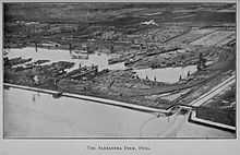
The Alexandra Dock was built between 1881 and 1885 on land reclaimed from the Humber as part developments made by the Hull Barnsley & West Riding Junction Railway and Dock Company, a railway and dock company. The dock design was by James Abernethy, and carried out by a partnership of engineers James Oldham and George Bohn, with A.C. Hurtzig as resident engineer. The contractors were Lucas and Aird. The dock machinery, including lock gates and unloading equipment was hydraulically powered and supplied by Armstrong, Mitchell & Company.[136][137]
The dock was built to the east of Victoria Dock with an outlet to the Humber. Water to fill the dock came from the Holderness Drain, which was intended to minimise the silting up of the dock that would be caused by ingress of water from the Humber; the dock had an area of 46.5 acres (18.8 ha), on a site of 192 acres (78 ha) of which 152 acres (62 ha) was on land within the tidal range of the Humber, requiring the construction of a 6,000 feet (1,800 m) embankment to reclaim the land. Steam and hydraulically powered equipment was used to aid the construction of the dock.[138][139][136] Blows (or "Boils"[note 18]) were encountered in the construction of the lock foundations, and at a point in the dock wall, which threatened to undermine the foundations and required remedial work.[140] The dock walls were planned to be built of chalk rubble faced with ashlar. A masons strike led to part of the lower part of the walls being built in portland cement. The tops of the dock walls were faced with granite.[141] Dredged material from the creation of a channel from the entrance to the deep water channel in the Humber was used to infill parts of the made walls in the dock and to embank the foreshore to the east of the dock.[142]
The dock was opened 16 July 1885, named after Alexandra, Princess of Wales. The cost of the works was £1,355,392.[136]
The entrance lock was 550 ft (170 m) long and 85 ft (26 m) wide. Two graving docks, one 500 ft (150 m) long and 60 ft (18 m) wide, the other a little bigger were built at the north-east corner of the dock. Its primary purpose was the export of coal.[139][map 15]
In 1899/1900 the dock was expanded by 7 acres (2.8 ha).[139][143] A pier onto the Humber Estuary (West Wharf) was added in 1911,[144] the pier was 1,350 ft (410 m) with a 18 ft (5.5 m) minimum depth of water at spring tides, and was equipped with electric conveyors for the transportation of coal.[114][map 16]
Alexandra Dock closed in 1982[145] at which time the connection to the rail network was removed,[146] in 1991 the dock re-opened[145] but without a rail connection.[147]
In the early 1990s part of the port land was developed as a dredged aggregate marine terminal and plant, operated as Humber Sand and Gravel Co. (est.1993), a joint venture between Hanson (formerly ARC) and CEMEX.[148][149][150] a concrete batching plant was built on the dock land in the late 1990s for Ready Mix Concrete Ltd. (later CEMEX UK Materials.[151]).[152]
In the 1990s development of a riverside container terminal, Quay 2000, was proposed;[153] the scheme, later named Quay 2005,[154] was located at the site of the West Wharf.[155] A public enquiry was required, due to objections from residents of the Victoria Dock Village,[156] the inspector recommended refusal of the scheme, but the decision was over-ruled by the Department of Transport,[157] and the project gained approved in December 2005.[158] The "Associated British Ports (Hull) Harbour Revision Order 2006" allowing the work came into effect in 2006.[159] Construction of the facility, renamed Hull Riverside Container Terminal, was initially planned to be complete by 2008; [160][161] construction of the terminal was delayed,[162] and the scheme was later adapted to attract an offshore wind power business to the port.[163] (See § Green Port Hull.)
As of 2010 the dock handled cargoes including aggregates, bulk agricultural products, bulk chemicals and wood, and also had a Ro-Ro terminal.[100]
Green Port Hull
In January 2011 Siemens and Associated British Ports signed a memorandum of understanding (MOU) concerning the construction of wind energy machine manufacturing plant at Alexander Dock.[164][165][166] Infrastructure for the proposed development would also make use of the planned Quay 2005 riverside facilities, which had already gained planning consent; and had an extant environmental mitigation at Chowder Ness.[167][168] The site was favoured due to its relative proximity to planned large scale wind farms in the North Sea (Dogger Bank, Hornsea, and East Anglia Array wind farms), and the presence of existing port infrastructure.[169]
The Quay 2005 scheme included reclamation of 19 acres (7.5 ha) of land west of the dock entrance, on the banks of the Humber estuary; in the original scheme the reclaimed area was roughly a right trapezoid which projected well over 100 metres (330 ft) into the Humber, with a south facing front of over 400 metres (1,300 ft);[170][note 21] the instrument also allowed dredging of the quay and approaches of up to 11.5 metres (38 ft) below chart datum.[171]
The development, Green Port Hull, included the Quay 2005 estuary wharf, repurposed as a facility for wind turbine logistics; and also required the infilling of the dock west of the lock gates with about 28,000,000 cu ft (780,000 m3) of material to create additional land for operations. The initial plan included a nacelle factory of up to 380,000 square feet (35,000 m2), plus office, warehousing, and external storage areas, as well as a helipad and a wind turbine of up to 6 MW. The works were to take up most of the dock area, with the exception of land around and including dry dock facilities in the northeast corner. Businesses located in the dock were to be relocated, primarily to other sites within the Port of Hull.[172][note 22]
Initial expectations were for construction to begin in 2012 and the facility be operational by 2014.[173] The conclusion of the agreement was delayed due to planning issues and uncertainties over the UK's renewable energy policy.[174] Relocation of existing businesses had taken place by 2012.[175]
The Siemens and ABP 2011 MOU agreement was finalised in March 2014.[176][note 23] ABP investment in the port facilities was estimated at £150 million, and Siemens investment at £160 million across the two sites. The facility was expected to become operational between 2016 and 2017.[176] Plans for the turbine factory were submitted and approved in 2014.[178][note 24] The contract (about £100 million) for dock civil engineering work was awarded to a joint venture of GRAHAM and Lagan Construction Group, with CH2M Hill as consulting engineers.[179] Official groundbreaking for took place in January 2015.[180] Revised plans for the site submitted April 2015 included only a blade manufacturing factory at the site, together with storage and other logistics facilities for wind farm installation work, with no nacelle production.[181]
The wind turbine factory scheme has an expected lifespan of around 30 years after which the site would be returned to general port use.[182]
King George Dock and Queen Elizabeth Dock
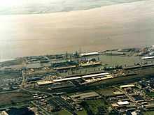
Built as a joint development between the Hull and Barnsley Railway and the North Eastern Railway, and contracted to S. Pearson in 1906,[183] the design was undertaken by Sir Benjamin Baker and Sir John Wolfe-Barry.[184][185] King George Dock (also known as the Joint Dock) was opened in 1914 by King George V.[183][185]
The dock's entrance lock was 750 ft (230 m) long and 85 ft (26 m) wide, the unexpanded water area was 53 acres (21 ha).[map 17] Two graving docks were also constructed in the north-east corner of the dock.[114] Initially primarily used for coal a grain silo was added in 1919,[185] initially used for imports and later for export of grain, the silo was demolished in 2010/11.[186][187]
In 1965 the creation of berths for use by roll-on roll-off ferries began the increasing use of Ro-Ro ferries at the dock for unit freight transport.[185] In 1968 work on a 28 acres (11 ha) extension to King George Dock built on reclaimed land to the south-east of the dock was begun, the extension was officially opened in August 1969 by Queen Elizabeth II and named Queen Elizabeth Dock.[118][map 18] At Elizabeth Dock a container terminal was opened in 1971, and two Ro-Ro terminals were opened in 1973, by 1975 there were six Ro-Ro terminals in the two docks.[118][188]
In 1990 PD Ports (originally Humberside Sea and Land Services) began operating the Hull Container Terminal. By the mid 2000s throughput was over 100,000 TEU per annum, with Samskip as the primary customer.[189]
In 1993 River Terminal 1 a terminal for large Ro-Ro vessels was opened on the banks of the Humber Estuary south of the King George Dock, constructed at a cost of £12 million.[190][map 19] A covered terminal was opened in 1997, initially built for steel handling for British Steel;[191] the terminal was renamed as Hull All-Weather Terminal in 2009, and the facilities expanded to allow the handling of other weather sensitive goods, including dry bulks, paper, and agribulks (fertiliser).[192][193] A covered shed for paper products (Finland terminal) was opened in 2000, by 2006 expanded to 70,000 sq ft (6,500 m2).[194]
In 2001 new facilities were inaugurated on the banks of the Humber were opened. The Rotterdam terminal (on the site of the 1993 River Terminal 1), was built at a cost of £14.3 million to serve the P&O North Sea Ferries' new ships, the Pride of Rotterdam and Pride of Hull, used on the Hull-Rotterdam route.[195]
As of 2010 other facilities at the two docks included a 850,000 cu ft (24,000 m3) cold store, and passenger services to Zeebrugge. The company AarhusKarlshamn operates a large vegetable based oil products processing plant at the dock, and the Kingston Terminal located at the south-east of Queen Elizabeth Dock is used for import of coal products. In 2010 there were ten Ro-Ro berths in total within the two docks.[100]
In 2013, a 1 million tonne per year capacity sea to rail biomass facility, with a 164 ft (50 m) silo was constructed to supply Drax power station.[196][197] The facility was officially opened by Councillor Mary Glew Lord Mayor of Hull in December 2014.[198][199]
Other facilities
Dry docks
In addition to the dry docks in King George, Alexandra, and William Wright docks there were dry docks on the sides of the River Hull.[200] Hull Central Dry Dock (also known as "South End Dock") on the west bank of the River Hull near to its outfall onto the Humber Estuary[map 20] was the largest, being 345 ft (105 m) long with an entrance of 51 ft (16 m),[200] the dock having been extended several times.[201] Built in 1843 and later extended the dock has been disused since 1992 and is now a Grade II listed structure.[201][202][203] In September 2013 the City Council approved plans by Watergate Developments Ltd to turn the dock into an open-air entertainment venue.[204]
On the east bank of the River Hull were Crown Dry Dock,[map 21] 104 by 21 ft (31.7 by 6.4 m)[200] half way between the river outfall and entrance to Victoria Dock's Drypool Basin. Further upstream was Union Dock, 214 by 48.5 ft (65.2 by 14.8 m),[200] opposite the entrance to Queen's Dock,[map 22] dating to the first half of the 1800s.[205] and a third dock further upstream.[map 23]
On the west bank of the River Hull there were ship repair facilities just within the city walls at North Gate on the river dating back as far as the 15th century, with slipways by the 18th century; the entrance to Queen's Dock was later built in this area, and two dry docks remain North Bridge Dry Dock and No.1 Dry Dock to the north and south of Queen's Dock basin respectively. North Bridge Dry Dock[map 24] and No.1 Dry Dock[map 25] were smaller dry docks of around 150 ft (46 m) long and with entrances less than 40 ft (12 m).[200] Both were extended in the latter part of the 19th century.[206][207] The northernmost of the two docks is a Grade II listed structure.[208] Additionally the former Queen's Dock basin was converted to an enclosed dock after the main dock was infilled.[209][210][map 2]
Quays, wharfs and piers
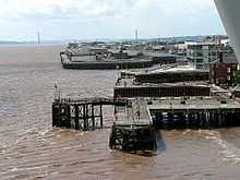
In addition to the Riverside Quay at Albert Dock, the former pier at Alexandra Dock, and the Ro-Ro river terminal at King George Dock there are other water side berths at the port, both on the Humber and on the River Hull.
The Corporation Jetty (or Old Corporation Pier, also known as Brownlow's Jetty) was located between Limekiln creek and the Humber dock west pier.[map 26] The construction of the West dock necessitated the demolition of the old pier.[211][212] The Hull and Selby Railway (1840) had a wharf at Limekiln Creek, a small north-south running harbour; also used by the Manchester, Sheffield and Lincolnshire Railway who operated a lighter service from it.[213][214][map 27] the Creek was stopped up as a result of the building of the West dock in the 1860s.[215] As a provision of the 1861 act replacement facilities were provided for the railway companies, at a place called Railway Creek.[216][217] The Railway Creek was constructed as part of the works for the new West Dock (Albert Dock); beginning 1863, a new harbour was formed east of Limekiln Creek; the Limekiln Creek was kept open until the alternative provision for the NER and MS&LR companies had been made.[218] After completion of the works the small east-west running Railway Creek harbour connected at its east end to the Albert Dock basin.[219][map 28] In 1873 the NER had a warehouse built at the site, designed by Thomas Prosser and modified by Benjamin Burley, both NER architects.[220][note 25]
Corporation Pier, first constructed in 1810 was parallel to the mainland but not directly connected to it,[221] it was converted to a "T" shaped pier in 1847.[221] It was used as the terminus of the Hull to New Holland ferry, initially run by the Manchester, Sheffield and Lincolnshire Railway (MS&LR), later by the LNER and British Rail, until the service ended in 1981 due to the opening of the Humber Bridge.[222] It was renamed Victoria Pier in 1854.[41][note 26][map 29] A railway booking office latterly named Hull Victoria Pier was established here c. 1849 by the MS&LR, and closed on 25 June 1981 with the cessation of the ferry service.[223] The pier has been altered several times during its existence, a floating pontoon was added in 1877, removed in 1980;[221] an upper Promenade was added in 1882,[224] and removed in the mid 20th century; as of 2005 the primary wooden structure is "L" shaped.[221]
To the west of Victoria Pier were the "L" shaped piers enclosing the Humber Dock basin,[225][226] The Humber Dock piers were modified from a diagonal arrangement (NE/SW) to a pier square to the dock (N/S) in around 1840.[227][228][note 27] The West Pier became defunct c. 1875 when the entrance basin of the Albert Dock was partially filled to provide more accommodation for the MS&LR, creating Island Wharf. Island Wharf was separated from the mainland by a channel known as Albert Channel; the channel was filled-in in the 1960s.[96][229][230] In 2004 the construction began on an office development known as Humber Quays began on the site. The first building was completed in 2006, a second office building was completed in 2007.[231]
The eastern pier was a wooden structure, from 1920s known as the Minerva Pier;[232] it was replaced by a steel walled pier in the latter part of the 20th century.[233][234]
As of 2010 the remaining piers are still used to harbour vessels, but are not used for cargo handling.
The River Hull had extensive staithes, wharfs and warehouses along its length; the Old Harbour could accommodate vessels up to 200 ft (61 m), the river being navigable for vessels up to 180 ft (55 m) for two miles.[235] As of 2010 cargo handling has mostly ceased in the Old Harbour, barges are still used for transportation of vegetable and mineral oils further upstream within the boundaries of Hull: including to Rix petroleum,[236] the Croda chemicals vegetable oil chemical processing plant[237] and to the Cargil vegetable oil plant in Stoneferry.
Salt End jetties
At Salt End a jetty (No.1 Oil Jetty) for the importation of bulk mineral oil was constructed in 1914 by the North Eastern and Hull and Barnsley railway companies, connected to a tank farm at Salt End. The jetty was constructed extending into the Humber, giving a water depth of 30 ft (9.1 m) at low spring tides.[114] Chemical industrial development fed by the oil imports would develop into the chemical site at Salt End now known as BP Saltend.
No.2 Jetty was constructed in 1928 westward of No.1, and a reinforced concrete structure No.3 Jetty was built 1958, the original No.1 jetty was demolished and replaced with a new structure in 1959.[118] No.2 jetty was demolished in 1977.[238] As of 2010 both No.1 and 3 jetties remain in use.[map 30]
Disasters, accidents and war damage
Explosion of the PS Union
In 1837 the packet steamer Union exploded in the Humber Dock basin,[239] resulting in the death of over twenty people including bystanders on the dock side, and a large number of injuries, the vessel itself being sunk by the explosion.[240][241]
R38 airship disaster
In 1921 a R38-class airship broke apart whilst performing a sharp turn near to Victoria Pier, the air-vessel then exploded, and the flaming wreckage crashed into the Humber near to the Victoria Pier killing 45 of the 49 on board.[242]
Second World War
During the Second World War the Hull docks were actively targeted; in addition to mines in the Humber,[243] the docks in Hull were bombed; all docks were damaged during the period, and the wooden Riverside Quay at Albert Dock was totally destroyed in 1941.[244]
Fires
Major fires destroyed the fish market at St. Andrews Dock in 1929, and a general cargo shed at Humber Dock in 1951.[245] In 1970 a vehicle carrying liquefied gas struck the top of a road subway leading to the William Wright and St. Andrew's docks, resulting in a gas explosion and fire. The incident caused two deaths and 17 serious injuries.[246][247]
See also
- Museums in Hull with exhibits relevant to the port
Notes
- ↑ Much from the North Yorkshire Moors then called Blackhower Moor, additionally wheat, corn, lead, leather were exported, later in the 14th century also cloth.
- ↑ Also dyestuffs – Madder, Woad as well as Alum for mordant, as well as wood, iron and iron ore and a wide variety of foreign goods.
- ↑ The east of the river not being developed until later
- ↑ The High Street still contains merchant buildings, most from a later date, Wilberforce House dates to 1660, and was once used for this purpose.[9]
- ↑ One clause of the Hull Docks Act of 1861 was that the Dock Company could be converted to a municipally owned dock trust by the Hull Corporation, additionally the dividends paid by the company were restricted: the Dock Company had been created as a private 'for profit' company, and was subject to widespread prejudice in the town of Hull that it better served the interests of the shareholders rather than the port itself; the shareholders were characterised as being uninterested in the development of the port.[19]
- ↑ 6.0 6.1 The docks were renamed in honour of Queen Victoria's and the Prince Consort's (Prince Albert) visit to Hull in 1854, during which the Royal Party made a tour of the docks on the steam-yacht "Fairy".[30]
- ↑ 7.0 7.1 The "Queen's Dock" proposal of 1838, forerunner of the Victoria Dock, should not be confused with the original Hull Dock of 1778, named "Queen's Dock" in 1854.
- ↑ The walls were demolished, but not all the gate, which was rediscovered in the 20th century – the part occupying the gap between the constructions of Queen's and Prince's Dock.[31]
- ↑ The land made was in the area of the Victoria Pier, south-east of the dock,[41] creating Nelson Street, and to the south and west of the dock, creating Wellington Street.[42]
- ↑ See footnote in Bethell (1841, p. 27) quote "The London Gazette of the 16th of November, containing the notice for a bill to make the Queen's Dock, was put in."
- ↑ Walker's 1840 dock was 14 acres (5.7 ha) in area with a quay area of around 21 acres (8.5 ha), with water depths of 23 to 17 feet (7.0 to 5.2 m) (high to low tides) in 9 acres (3.6 ha) of the dock nearer to the Humber lock, with the remainder of the dock shallower with depths of 20 to 14 feet (6.1 to 4.3 m); his cost estimate was £300,000. The dock was to have a 5 acres (2.0 ha) entrance basin on the Humber; and a lock suitable for the largest paddle steamers of the day, 210 by 60 feet (64 by 18 m), and a 36 feet (11 m) wide passage onto the Old harbour.[65]
- ↑ Wright (1875, p. 87) states that "it was originally intended to construct this dock [] with an entrance from the Humber only..", however the original London Gazette notice of 1839 describes a link to the Old harbour,[62] as do the Minutes of the June 1840 parliamentary committee examining the bill.[66] The link to the River Hull for the built dock was not constructed till the early 1850s.[67]
- ↑ Dock: 12 acres 3 rods 13 perch; Half-tide basin: 3 acres; Victoria Dock basin: 2acres 3rods; and the Drypool basin 1 acre 20 perch. Sheahan (1864, p. 293)
- ↑ One lock was narrower and intended for barges.[71]
- ↑ The Drypool basin and connection to the River Hull was completed in the early 1850s; the entrance on the River Hull had not been sanctioned at the time of the formal opening (1850), it was completed soon after, being under construction by 1852.[67]
- ↑ See: the 1860 West Dock Company London Gazette notice,[84] and the 1860 Hull Dock Company London Gazette notice.[85]
- ↑ The 1865 and 1866 London Gazette notices:
- "Hull Docks. (Enlargement of Western Dock and Works ..". London Gazette (23042): 5714. 24 November 1865.
- "Hull Docks; Enlargement and Extension of Works in connection with the Western Dock ..". London Gazette (23189): 6358–6359. 23 November 1866.
- ↑ 18.0 18.1 Underground 'streams' forcing up through sand, with an origin in the aquifers of the Yorkshire Wolds.[90][91]
- ↑ Allison (1969) gives an incorrect date of 1865 for the authority to build the William Wright Dock.
- ↑ Wright (1875, p. 90) says the dock was intended for general trade.
- ↑ Roughly approximating to the outline of the 1911 "West Wharf".
- ↑ Hull City Council planning applications:
- "(11/01178/PAAD) Infilling of parts of Alexandra Dock (7.68 Ha; 19 Acres), construction of 2 roll on – roll off ramps within the Dock, and refurbishment of existing eastern lead in jetty to Alexandra Dock [..]". 14 December 2011.
- "(11/01180/LBC) Listed Building Consent Application for works associated with the Green Port Hull development involving [..]". 14 December 2011.
- "(11/01177/OUT) Development of land at Alexandra Dock, including the demolition of existing buildings (excluding the listed hydraulic engine house and tower and adjacent unlisted chimney), for use as a facility for the manufacture, assembly, storage, handling and testing of wind turbine components for the offshore power industry [..]". 14 December 2011.
- "(11/01176/S73) Green Port Hull: Application under section 73 of the Town and Country Planning Act 1990 to carry out works authorised by The Associated British Ports (Hull) Harbour Revision Order 2006 [..]". 14 December 2011.
- "(11/01179/FULL) Demolition of existing building and full planning permission for the erection of a 3 MW operational wind turbine [..]". 15 December 2011.
- ↑ An additional site near Paull, East Riding of Yorkshire, east of King George Dock, Hull was added to the plans, intended to manufacture rotor blades for turbines.[176] In late 2014 modified plans combined the two production facilities at Alexandra Dock.[177]
- ↑ Hull City Council planning application:
- "(14/00777/FULL) Demolition/partial demolition of existing buildings; erection of buildings (including a single building of 22.991m high) [..]". 19 June 2014.
- "(14/00778/FULL) Demolition of existing buildings and erection of service and logistics building [..]". 19 June 2014.
- "(14/00776/FULL) Erection of 6 x electricity sub stations [..]". 19 June 2014.
- ↑ The Railway Creek was filled in c. 1906s. (Ordnance Survey 1:10000 1970) See also Albert Channel
- ↑ Both names were commonly used
- ↑ See also Ordnance Survey Town Plans 1:1056 c. 1850.
References
- ↑ Gillett & MacMahon 1980, Chapter 1 'Beginnings of the Medieval Town'.
- ↑ "Port of Hull". Associated British Ports. Archived from the original on 16 July 2011.
- ↑ Lewis 1991, p. 158.
- ↑ 4.0 4.1 MacTurk, G.G. (1879). "Chapter I "Early Approaches to Hull"". A History of the Hull Railways.
- ↑ Gillett & MacMahon 1980, Chapter 2 "The Medieval Trade of Hull".
- ↑ Gillett & MacMahon 1980, Chapter 6 "The Market, the Ferries, and Foreign Trade.
- ↑ Gillett & MacMahon 1980, Chapter 8 "Hull in the Early 16th century".
- ↑ Gillett & MacMahon 1980, Chapter 15 "Hull under Charles II and James II".
- ↑ "Wilberforce House and Hull's High Street". Hull City Council. Retrieved 19 January 2013.
- ↑ 10.0 10.1 10.2 10.3 Gillett & MacMahon 1980, pp. 219–222, Chapter 17 "The Beginnings of the Modern Port"
- ↑ 11.0 11.1 11.2 Lewis 1991, pp. 158–159, Chapter 11 "Ports and Harbours"
- ↑ Jackson 1972, pp. 234–243, Chapter X "The Provision of Modern Port Facilities".
- ↑ "Hull’s docks and trade". Hull City Council. Archived from the original on 1 July 2008.
- ↑ Government of George III (1780). "Publick quays of wharfs to be established at Kingston upon Hull, for the better securing his Majesty's revenues ...". A collection of all the statutes now in force: relating to the revenue and officers of the customs in Great Britain and the plantations 2. C. Eyre and W. Strahan. pp.1411–1416; p.1414, XVIII, "Crown land granted for the above purpose".
- ↑ 15.0 15.1 15.2 Lewis 1991, p. 159
- ↑ Ellis & Crowther 1990, p. 423, Chapter 30 "Development of the Humber during the nineteenth and twentieth centuries", (J. North)
- ↑ Waterston, William (1846). "Dock: III. Docks at other ports of the United Kingdom, p.256". A cyclopædia of commerce, mercantile law, finance, commercial geography, and navigation. Henry G. Bohn (London).
- ↑ 18.0 18.1 18.2 "SPG Note 27 Heritage & Development Management at Garrison Side, Hull" (PDF). Hull City Council. 15 July 2004. sections 27.5 to 27.13: "Historical Background", pp. 167–168. also historical maps of the near area, and information on the Hull Citadel
- ↑ 19.0 19.1 19.2 19.3 Allison 1969, "The Corporation and the Dock Company, 1835–70"
- ↑ Sheahan 1864, pp. 293–295
- ↑ 21.0 21.1 21.2 Tomlinson 1914, pp. 715–716
- ↑ Tomlinson 1914, pp. 707–708.
- ↑ Tomlinson 1914, pp. 711–715.
- ↑ Tomlinson 1914, pp. 716–721.
- ↑ Tomlinson 1914, pp. 767.
- ↑ 26.0 26.1 Parkes 1970, p. 6
- ↑ Sources:
- Jarvis, Adrian (1998). Port and harbour engineering. Studies in the history of civil engineering (6) (Ashgate). p. 162.
- Labrum, E.A. (1994). "2. Humberside and North Lincolnshire: 3. Hull Town Docks". Civil Engineering Heritage: Eastern and Central England. Thomas Telford. ISBN 07277-1970-X.
- Skempton et al. 2002, pp. 333–4, HOLT, Luke (c. 1723–1804)
- Skempton et al. 2002, p. 54, BERRY, Henry (1719–1812)
- Skempton et al. 2002, p. 283, GRUNDY, John. Jr. (1719–1783)
- ↑ Sheahan 1864, pp. 287–289, "The Docks".
- ↑ 29.0 29.1 Head, George (1836). "Hull". A home tour through the manufacturing districts of England: in the summer of 1835 1. John Murray, London. p. 235.
- ↑ Sheahan 1864, pp. 190 and 289.
- ↑ "Coast Walk: Point 8 – Beverley Gate". BBC Humberside. BBC. Retrieved 20 January 2013.
- ↑ Parsons 1835, p. 219.
- ↑ "Port of Hull, Hull Docks.. Page 1". website.lineone.net. Queens Dock. Retrieved 20 January 2013.
- ↑ "Coast Walk, Point 1: Queen's Gardens". BBC Humberside. BBC. Retrieved 20 January 2013.
- ↑ Gillett & MacMahon 1980, pp. 222–224.
- ↑ Skempton et al. 2002, pp. 126 and 132, "CHAPMAN, William, MRIA (1749–1832).
- ↑ Skempton et al. 2002, pp. 554–566, RENNIE, John, FRS, FRSE (1761–1821).
- ↑ Skempton et al. 2002, p. 298, "HARRAP, John (1769–1812)".
- ↑ 39.0 39.1 "A Guide to the City’s Heritage Plaques" (PDF). Waterfront Communities Project. Hull City Council. No. 9 "Humber Dock". Archived from the original (PDF) on 19 April 2013.
- ↑ 40.0 40.1 Parsons 1835, p. 220
- ↑ 41.0 41.1 "Coast Walk: Point 5 – Victoria Pier". BBC Humberside. BBC. Retrieved 20 January 2013.
- ↑ Old Town (Southern part), section 6.7, p.4
- ↑ Gillett & MacMahon 1980, pp. 223–225.
- ↑ Skempton et al. 2002, p. 708, "TIMPERLEY, John (1796–1856).
- ↑ Gillett & MacMahon 1980, p. 224, "Beginnings of the Modern Port".
- ↑ Sheahan 1864, pp. 290–291
- ↑ Parsons 1835, p. 221.
- ↑ 48.0 48.1 "A Guide to the City’s Heritage Plaques" (PDF). Waterfront Communities Project. Hull City Council. No. 4 "Prince's Dock". Retrieved 20 January 2013.
- ↑ Gibson, Paul (January 2010). "A short history of Hull's fountains". Retrieved 1 February 2013.
- ↑ "(Notice is hereby given..)". London Gazette (20345): 1728. 21 May 1844.
- ↑ "(Notice is hereby given..)". London Gazette (20410): 4426–4427. 20 November 1844.
- ↑ 52.0 52.1 52.2 Sheahan 1864, p. 292.
- ↑ Wood 1845, pp. 37.
- ↑ 54.0 54.1 Wood 1845, p. 45.
- ↑ Tomlinson 1914, pp. 337–343, Chapter X "The Opening of Many Lines (1836–41)".
- ↑ "A Guide to the City’s Heritage Plaques" (PDF). Waterfront Communities Project. Hull City Council. No. 29 "Railway Dock". Retrieved 20 January 2013.
- ↑ 57.0 57.1 Wright 1875, p. 87.
- ↑ "Plan of a Proposed New Dock at Kingston-Upon-Hull". The Civil Engineers and Architect's Journal 2: 16. 1839.
- ↑ "(Hull Dock Act, Solicitor Thomas Holden, 1st November 1838)". The London Gazette (19674): 2565. 16 November 1838.
- ↑ Bethell 1841, 488–506, pp.25–26.
- ↑ Bethell 1841, 541–554, p.28.
- ↑ 62.0 62.1 "(Hull Dock Act, Solicitor for the Dock Company Charles Frost, 7th October 1839)". The London Gazette (19781): 1971. 22 October 1839.
- ↑ Bethell 1841, 24–39, p.6; 63–70, p.7; 445–446, pp.23–24.
- ↑ Bethell 1841.
- ↑ 65.0 65.1 Bethell 1841, 541–709, pp.28–34.
- ↑ Bethell 1841, 165, pp.11–12; 644, p.31.
- ↑ 67.0 67.1 Sources:
- Hodgson, Henry; Scotland, Colley Harman; Russell, Francis (1852). "The Queen v. the Dock Company at Kingston-upon-Hull (1852 April 21)". Reports of cases relating to the poor laws, the criminal law, and other subjects, chiefly connected with the duties and office of magistrates decided principally in the court of the Queen's bench and the court for Crown cases reserved from Michaelmas term 1851, to Trinity term 1852.. The Law Journal Reports (new series vol.21). pt.3 of v.30 (Edward Bret Ince). pp. 153–160.
The Victoria Dock, which is on the east side of the River Hull, communicates through its basin with the River Humber to the south, and it is also intended, and by the last recited act required, to communicate with the River Hull or Old Harbour to the west by means of a cut or communication which is not yet completed, but which is in the course of construction, and is expected to be completed in about a year. Upon the completion of that cut or communication, vessels entering the Victoria Dock basin from the Humber, will be able to pass through and use all the docks, and to return into the Humber by the Humber Dock basin, or vice versa
- Urban, Sylvanus, ed. (1850). "Historical Chronicle". The Gentleman's magazine 34. John Bower Nichols and Son. Provincial Intelligence: Yorkshire: July 3, p.198.
The plans for the last link of the present series of docks at Hull, namely, the Drypool Basin, and entrance to Victoria Dock, await the sanction of the Admiralty, which is expected forthwith
- Hodgson, Henry; Scotland, Colley Harman; Russell, Francis (1852). "The Queen v. the Dock Company at Kingston-upon-Hull (1852 April 21)". Reports of cases relating to the poor laws, the criminal law, and other subjects, chiefly connected with the duties and office of magistrates decided principally in the court of the Queen's bench and the court for Crown cases reserved from Michaelmas term 1851, to Trinity term 1852.. The Law Journal Reports (new series vol.21). pt.3 of v.30 (Edward Bret Ince). pp. 153–160.
- ↑ "(NOTICE is hereby given ..)". London Gazette (20280): 3753–3754. 15 November 1843.
- ↑ 69.0 69.1 Sheahan 1864, pp. 292–3
- ↑ 70.0 70.1 Wright 1875, p. 89.
- ↑ "Local buildings list" (PDF). Hull City Council. 2014. p. 46.
- ↑ Allison 1969, Economy, 1835–70.
- ↑ York and North Midland Railway Company (3 November 1849). "Conclusion of the York and North Midland Committee's Third Report". Herapath's Railway Journal 11 (543). p.1114, cols.1–2.
- ↑ Wood 1845, footnote, p.37.
- ↑ "A Tale of Two Rivers" (PDF). The Deep. A History of Sammy’s Point. Retrieved 22 February 2011.
..and when Victoria Dock was built in 1850 the dug out mud was used to reclaim even more land at the point. Martin Samuelson set up a shipyard in 1857 on this new piece of land .. 1864 the point was sold to the Humber Iron Works and Ship Building Company .. 1872 was bought by Bailey and Leetham Ship Owners .. 1903 it was bought by Thomas Wilson and Son
- ↑ "Exhibition keeps river shipyard's fame afloat". Yorkshire Post. 15 March 2004.
- ↑ "Cook, Welton and Gemmel and their successors". Access to Archives. The National Archives. Retrieved 20 January 2013.
- ↑ "History of the Dock". Victoria Dock Village Hall Community Association. Retrieved 20 January 2013.
- ↑ Ordnance Survey Sheet 240NE (1888–1950)
- ↑ Ordnance Survey 1:2500 1951, 1969–70
- ↑ Thomson 1990, pp. 32–5, "Victoria Dock 1850–1970".
- ↑ "Kingston upon Hull Docks Page – Two". www.riverhumber.com. Victoria Dock. Retrieved 20 January 2013.
- ↑ Sheahan 1864, p. 294.
- ↑ "Hull West Dock". The London Gazette (22446): 4197–4202. 13 November 1860.
- ↑ Moss & Dyson and Co. 1860.
- ↑ 86.0 86.1 Hawkshaw 1875, pp. 92–3.
- ↑ 87.0 87.1 Hawkshaw 1875, pp. 94–5.
- ↑ 88.0 88.1 Wright 1875, pp. 89–90.
- ↑ 89.0 89.1 Hawkshaw 1875, pp. 95–98.
- ↑ Hawkshaw 1875, pp. 101–2.
- ↑ Hurtzig 1888, pp. 167–8.
- ↑ Hawkshaw 1875, pp. 98–109.
- ↑ Vernon-Harcourt 1885, pp. 522–523, 524.
- ↑ 94.0 94.1 Railway News 24 July 1869.
- ↑ Hawkshaw 1875, p. 93.
- ↑ 96.0 96.1 96.2 96.3 Wright 1875, p. 90.
- ↑ Hawkshaw 1875, pp. 113.
- ↑ 98.0 98.1 Thompson 1990, pp. 36–43, "Albert and William Wright Docks 1869"
- ↑ "Port of Hull – facilities". Associated British Ports. Archived from the original on 26 May 2010., see also "Commodities"
- ↑ 100.0 100.1 100.2 "Port of Hull: Commodities". Associated British Ports. Archived from the original on 30 January 2010.
- ↑ "Agency urged to fix flaw in Hull’s flood defences". Yorkshire Post. 4 February 2014.
- ↑ Young, Angus (4 February 2014). "Hull floods report: 'Raise level of Albert Dock defences'". Hull Daily Mail.
- ↑ Young, Angus (5 February 2014). "Flood defence work at Hull's Albert Dock to be brought forward". Hull Daily Mail.
- ↑ Simpson 2009, p. 27, "1873".
- ↑ "Dock Extension at Hull" (PDF). The Engineer 41: 327. 28 April 1876.
- ↑ Allison 1969, "The Corporation and the Docks, 1870–1914"
- ↑ "NORTH EASTERN RAILWAY. (Additional powers with reference to New and Existing Railways, Roads, Footpaths and other Works and Lands [..]; Power to make Dock Works at Hartlepool and Kingston-upon-Hull and a Pier in the River Humber; [..] )". The London Gazette (27736): 7493–7497. 18 November 1904.
A river wall or quay [..] on the foreshore of the River Humber commencing at the south-eastern corner of the Albert Dock entrance and terminating at a point in the existing river wall or embankment about 20 yards east of a line drawn in a southerly direction from the western end of the Company's William Wright Dock. [..] (a) To deepen, dredge, scour, cleanse, alter and improve from time to time the bed, shores and channel of the River Humber adjoining or near to the said intended pier in the River Humber and the said intended river wall or quay at Kingston-upon-Hull. (b) To re-arrange, re-construct, alter and divert the existing railway sidings, bridges, staiths, roads, footpaths and other works [..]
- ↑ 108.0 108.1 The Engineer (1 July 1910) p.6, cols.2–3
- ↑ 109.0 109.1 Wright 1932, p.69; illustration p.71
- ↑ Improvements at the Port of Hull (PDF). The Engineer 102. 9 October 1906. p. 396.
- ↑ The Engineer (1 July 1910) p.6, col.3; p.7, col.1
- ↑ 112.0 112.1 The Engineer (1 July 1910) p.7, col.2
- ↑ Fawcett, Bill (2005). A History of North Eastern Railway Architecture 3. North eastern Railway Association. p. 24.
- ↑ 114.0 114.1 114.2 114.3 Appleby 1921, pp. 17–22
- ↑ The Engineer (1 July 1910) p.6, col.3
- ↑ Mason, Eric (1954). The Lancashire & Yorkshire Railway in the Twentieth Century. I. Allan. p. 38.
- ↑ The Railway Gazette 32: 95. 1920. Missing or empty
|title=(help) - ↑ 118.0 118.1 118.2 118.3 118.4 118.5 118.6 British Transport Docks Board 1975, pp. 21–25, "History of the Port of Hull"
- ↑ "The Humber" (PDF). The Engineer 111: 4. 6 January 1911.
- ↑ See Hull Blitz § 1941
- ↑ Thompson 1990, pp. 36–43, "Albert and William Wright Docks 1869"
- ↑ 122.0 122.1 122.2 "Urban Conservation and Design, St. Andrews Dock, Conservation Area Character Statement" (PDF). Hull City Council. 23 October 1996.
- ↑ Ordnance Survey. Sheet 240NW 1906–1908
- ↑ "Singular Accident at Hull Docks". The Guardian. 16 May 1896. p. 7.
- ↑ "Rail and Road" (PDF). The Engineer 161: 677. 26 June 1936.
- ↑ "The North-East Coast and Humber Ports" (PDF). The Engineer 163: 34–35. 8 January 1937.
- ↑ "Hull Fish-Dock Improvement – Modified Scheme". The Guardian. 30 December 1938. p. 3.
- ↑ "St. Andrew's Dock, Hull (Reconstruction)". House of Commons sitting (Hansard) 474. cc1649-58. 1 August 1957.
- ↑ Thompson 1990, pp. 44–9, "St. Andrews Dock".
- ↑ "The Junction, St Andrews Quay, Retail Park, Clive Sullivan, Way, Hull, HU3 4SA, Phase 1" (PDF). Completely Retail. Retrieved 12 June 2012.
- ↑ "The Junction, St Andrews Quay, Retail Park, Clive Sullivan, Way, Hull, HU3 4SA, Phase 2" (PDF). Completely Retail. Retrieved 12 June 2012.
- ↑ Sykes, Alan (22 March 2013). "Hull seeks designer for a memorial to its lost trawler crews". The Guardian.
- ↑ "Hull's lost trawlermen memorial designs go on display". BBC News (BBC). 19 July 2013.
- ↑ "Hull's lost trawlermen memorial competition winner unveiled". BBC News (BBC). 29 July 2013.
- ↑ "Finding the right words to remember Hull's lost trawlermen". Hull Daily Mail. 5 December 2013.
- ↑ 136.0 136.1 136.2 Abernerthy, John Scott (1897). The life and work of James Abernethy. pp. 186–192.
- ↑ Hurtzig 1888, pp. 144–5.
- ↑ Hurtzig 1888, pp. 145–148.
- ↑ 139.0 139.1 139.2 Parkes 1970, "Docks and Piers", pp.12–13
- ↑ Hurtzig 1888, pp. 148, 150–2, 152–3.
- ↑ Hurtzig 1888, pp. 154–5.
- ↑ Hurtzig 1888, pp. 156–8.
- ↑ Hobson, Bernard (1924). "16 Shipping and Trade". The East Riding of Yorkshire ( with York). Cambridge County Geographies. p. 81. ISBN 9781107690356.
- ↑ "Kingston upon Hull City Docks Page Three". www.riverhumber.com. Alexandra Dock. Retrieved 20 February 2011.
- ↑ 145.0 145.1 Simpson 2009, p. 28, "1885, 16th July"
- ↑ Dodsworth, Ted (1990). The train now standing (Vol.1): The Life and Times of the Hull and Barnsley Railway. Hutton Press. p. 21.
- ↑ Chapman, Stephen, ed. (1999). Railway Memories No.12: The Hull & Barnsley Railway. Bellcode Books. pp. 7–10, 46, 51. ISBN 1871233119.
- ↑ URS (January 2014). "Marine Aggregates Study" (PDF). Leeds City Council. p.8; §2.2, pp.17–18; §2.3, pp.19–21; §4.4.2 p.34; §7.1, p.52; Photo.1–3, pp.70–71.
- ↑ Hanson Group (1 February 2013). "AGGREGATES, RMX AND CEMENT MIR – HANSON RESPONSE TO THE UPDATED ISSUES STATEMENT" (PDF). §4.7.3, p.9.
- ↑ "(90/01271/PF) 1: CHANGE OF USE FROM DOCK LAND TO MARINE DREDGED AGGREGATE DEPOT FOR STORAGE, WASHING, CRUSHING, GRADING AND DISTRIBUTION OF AGGREGATES. 2. [..]". Hull City Council. 10 January 1990.
- ↑ "Hull Plant". www.agg-net.com. Retrieved 4 July 2014.
- ↑ "(95/01147/PF) 1. CHANGE OF USE OF VACANT DOCK LAND TO CONCRETE BATCHING PLANT 2. [..]". Hull City Council. 15 March 1995.
- ↑ "Port of Hull". The Dock and Harbour Authority: 283–4. 1996.
- ↑ Wang, James Jixian; Olivier, Daniel; Notteboom, Theo; Slack, Brian, eds. (2007). Ports, Cities, and Global Supply Chains. Table 5.2, p.60. ISBN 978-0-7546-7054-4.
- ↑ "(00/01209/ZZ) HARBOUR REVISION ORDER UNDER SECTION 14 OF THE HARBOURS ACT 1964 AUTHORISING THE CONSTRUCTION OF A NEW FACILITY IN THE RIVER HUMBER ADJOINING ALEXANDRA DOCK, HULL TO REPLACE THE EXISTING PIER IN THE RIVER – QUAY 2005". Hull City Council. 17 October 2000.
- ↑ "Quay 2005 future decision end of year". www.planningresource.co.uk. 25 July 2003.
- ↑ Atkinson, David (2007). "Kitsch geographies and the everyday spaces of social memory" (PDF). Environment and Planning 39. Defending maritime kitsch: Quay 2005, pp.535–7. doi:10.1068/a3866.
- ↑ "Hull Port Project Gets Go-ahead". www.gov-news.org. 21 December 2005.
- ↑ ABP harbour revision order (2006)
- ↑ "NOTES OF THE 4TH HUMBER LIAISON SUB-COMMITTEE MEETING HELD AT PORT HOUSE, HULL ON WEDNESDAY, 26 JULY 2006" (PDF). www.humber.com. 26 July 2006. pp. 2, 5.
- ↑ "First port of call". www.europeanoilandgas.co.uk. 21 August 2008.
- ↑ "Easy as ABP? New riverside terminal delays". www.globmaritime.com. 20 February 2008.
- ↑ "Docks battle paves way for golden chance". Hull Daily Mail. 3 December 2010.
- ↑ Bounds, Andrew (20 January 2011). "Hull for wind turbine plant". Financial Times.(subscription required)
- ↑ "Siemens selects ABP as preferred bidder for UK wind turbine factory". www.siemens.co.uk (Press release). Siemens. 20 January 2011.
- ↑ Webb, Tim (20 January 2011). "Siemens chooses Hull for wind turbine plant generating 700 jobs". The Guardian.
- ↑ "Green Port Hull to transform the Humber economy". Hello from Hull and East Yorkshire. Bondholderscheme Ltd. 6 December 2010.
- ↑ "Green Port Hull aims to transform economy". Maritime Journal. 8 December 2010. Archived from the original on 14 July 2011.
- ↑ Scott Wilson & URS 2011, §2.15, pp.4–5.
- ↑ ABP harbour revision order (2006), §4 "Work No.1", p.3
- ↑ ABP harbour revision order (2006), §9 "Power to dredge in Humber", p.4
- ↑ Scott Wilson & URS 2011, pp.i–vi; §2.5–2.6, p.3; §2.16–2.17, pp.5–6; figs. 2.2, 2.4, 2.5, 3.1.
- ↑ Scott Wilson & URS 2011, §2.21–2.26, pp.6–7.
- ↑ "Delay in signing Hull Green Port wind turbine factory deal". BBC News Humberside. 11 October 2012.
- ↑ Coggan, Allison (4 December 2012). "Hull firms relocate to make way for Siemens". Hull Daily Mail.
- ↑ 176.0 176.1 176.2 Sources:
- "Siemens confirm Green Port Hull wind turbine factory to be built". BBC News. 25 March 2014.
- "Siemens to construct factory for offshore wind power in Great Britain" (PDF) (Press Release). Siemens. 25 March 2014.
- "Siemens Hull: A view of things to come on the Humber". Hull Daily Mail. 26 March 2014.
- ↑ "Siemens combines Humber sites". renews.biz. 14 November 2014.
- ↑ "Siemens submits detailed plans for Hull offshore wind turbine plant’ bigger than Wembley pitch". Hull Daily Mail. 1 July 2014.
- ↑ "GRAHAM Lagan Construction Group Joint Venture named main contractor for Green Port Hull build". www.laganconstructiongroup.com. 7 November 2014.
- ↑ "Siemens fires Hull starter pistol". renews.biz. 22 January 2015.
- ↑ Pringle Brandon Perkins + Will; Blue Sky Planning, "Siemens Green Port Hull Alexandra Dock, 30 March 2015, Planning and Design and Access Statement" (PDF), (15/00393/RES) Demolition of buildings and erection of new buildings (including part of a single building of 22.476m high; 73' 9") for the manufacture of wind turbine blades and the assembly, maintenance, storage and distribution (Use Class B1, B2 and B8) of wind turbine components [..] (planning application) (Hull City Council), §01.1-01.2, pp.6-7
- ↑ Scott Wilson & URS 2011, §2.38, p.8.
- ↑ 183.0 183.1 Gillett MacMahon, p. 355, Chapter 25 "Pre War"
- ↑ UNKNOWN (1907). "Obituary, Sir Benjamin Baker, Kcb, Kcmg, Dsc, Lld, Mai, Frs, 1840–1907". Minutes of the Proceedings 170 (1907): 377. doi:10.1680/imotp.1907.17263.
- ↑ 185.0 185.1 185.2 185.3 "King George Dock, Hull". Engineering Timelines. Retrieved 20 January 2013.
- ↑ "Final days for King George Dock grain silo that helped feed the world". This is Hull and East Riding. 27 December 2010.
- ↑ "End of an era for silos used in Geldof's famine relief". This is Hull and East Riding. 5 January 2011.
- ↑ British Transport Docks Board 1975, pp. 43–7
- ↑ "Pd Ports Agrees Deals With Abp And Samskip At Hull Container Terminal". www.prlog.com (Press release). 11 June 2008.
- ↑ Hull Port & Commercial Handbook, 1995, pp. 11–12
- ↑ "New steel terminal increases cranage". www.hoistmagazine.com. 10 November 1998.
- ↑ "Port of Hull launches all-weather terminal". www.porttechnology.org. 8 September 2009.
- ↑ "Port of Hull’s All Weather Terminal handles first bulk fertiliser shipment". www.ukwa.org.uk (news). 11 February 2010.
- ↑ "ABP Invests £4.8 million in new developments for Port of Hull's Finland Terminal" (Press release). Associated British Ports. 30 March 2006. Archived from the original on 28 September 2011.
- ↑ "NEW PASSENGER TERMINAL FOR ASSOCIATED BRITISH PORTS’ PORT OF HULL". www.abports.co.uk. 1 May 2001. Archived from the original on 16 July 2011.
- ↑ Portz, Tim (16 July 2013). "Preparing for a Pellet Tide". Biomass Magazine.
- ↑ Covill, Rachel (30 May 2013). "New landmark as Spencer Group constructs biomass loading facility". TheBusinessDesk.(registration required)
- ↑ "Hull's new biomass fuel plant for Drax power station". BBC News (BBC). 3 December 2014.
- ↑ "Official opening of biomass terminal at Port of Hull signals start of City’s renewables revolution" (Press release). ABP. 4 December 2014.
- ↑ 200.0 200.1 200.2 200.3 200.4 Appleby 1921, p. 28, "Table of Dry Dock Information"
- ↑ 201.0 201.1 Gibson 1998, South End Graving Dock.
- ↑ Historic England. "Central Dry Dock/ Sand Southend Wharf (1375866)". National Heritage List for England. Retrieved 5 December 2012.
- ↑ Old Town (Southern part), section 14.13, p.20
- ↑ "Hull Central Dry Dock amphitheatre plan approved". BBC News (BBC). 4 September 2013.
- ↑ "Conservation list" (PDF). Hull City Council. Retrieved 20 February 2011.
- ↑ Gibson 1998, No.1 Dry Dock.
- ↑ Gibson 1998, North Bridge Yard.
- ↑ Historic England. "Dry Dock on South Side of Charlotte Street (1208717)". National Heritage List for England. Retrieved 5 December 2012.
- ↑ Harrop, Paul. "TA1029: Former dry dock, Hull". Geograph.
The 11 acre Queen's Dock was opened in 1778 and closed in 1930. The main dock was filled in to create Queen's Gardens and the dock basin was reused as a dry dock from 1957 up until the end of the 20th century.
- ↑ Pevsner & Neave 1995, p. 528, "The Docks".
- ↑ Ordnance Survey. Town plans 1:1056 1855–6; Town plans 1:500 1891
- ↑ Moss & Dyson and Co. 1860, para.2.
- ↑ Tomlinson 1914, pp. 340–1, 490–1.
- ↑ MS&LR Limekiln Creek service:
- Dow, G. Great Central 1. p. 172.
- Allison (1969, Communications: Railways)
- ↑ Moss & Dyson and Co. 1860, para.3.
- ↑ Moss & Dyson and Co. 1860, paras.11 & 12.
- ↑ 24 & 25 Vic., Cap.79 1861, § 40–41, 44–51.
- ↑ Hawkshaw 1875, pp. 93, 95–6.
- ↑ Ordnance Survey. Town Plans 1:500 1891
- ↑ Fawcett, Bill (2003). A History of North Eastern Railway Architecture 2. North eastern Railway Association. pp. 83–85.
- ↑ 221.0 221.1 221.2 221.3 Old Town (Southern part), section 14.12: 4 "Victoria Pier", p. 19
- ↑ Catford, Nick; Dyson, Mark (20 April 2010). "Station Name: Hull Corporation Pier". Disused Stations. Subterranea Britannica.
- ↑ Butt, R. V. J. (1995). The Directory of Railway Stations: details every public and private passenger station, halt, platform and stopping place, past and present (1st ed.). Sparkford: Patrick Stephens Ltd. p. 125. ISBN 1-8526-0508-1. OCLC 60251199.
- ↑ Miles, Philip C. Hull's Waterfront. "Victoria Pier and the Humber Ferries", pp.58–63.
- ↑ "5. Hull to Withernsea". Handbook for travellers in Yorkshire. John Murray, London. 1867. "The Humber Dock", p.91.
- ↑ Ordnance Survey Map, 1856–7, 1:1056
- ↑ Bethell 1841, 754–755, p.36.
- ↑ Wood 1845, p. 48.
- ↑ Ordnance Survey Map, 1891–3, 1:2500
- ↑ Old Town (Southern part), section 14.11, p.18
- ↑ Sources:
- "Work starts on Island Wharf". BBC News. 1 February 2004.
- "Two Humber Quays". www.hull.co.uk. Retrieved 26 July 2014.
The construction of Two Humber Quays, developed by Priority Sites was completed in November 2007
- "Engineering firm buys landmark Humber Quays building". Hull Daily Mail. 21 September 2011.
ONE Humber Quays has been acquired by a thriving Humber-based firm [..] The move will see the building fully occupied for the first time since it opened in 2006
- ↑ Ordnance Survey maps, 1:2500, (1910 and 1928 editions), also (Wright 1932, p. 62)
- ↑ Old Town (Southern part), section 14.12, 5. "Minerva Pier", p. 19
- ↑ "Minerva Pier & Island Wharf – Hull" (PDF). Alan Wood & Partners. Retrieved 19 January 2013.
- ↑ Wright 1932, pp. 73–4, "The River Hull".
- ↑ "Domestic Heating Oil & Commercial Fuels:". www.rix.co.uk. Retrieved 26 July 2014.
- ↑ "Corporate Social Responsibility". Croda. 2007. p. 23.
- ↑ Thompson 1990, pp. 82–84, "Salt End Oil Jetties 1914".
- ↑ "Packet Boats and Steamers". www.humberpacketboats.co.uk. P.S. Union. Retrieved 19 January 2013.
- ↑ Dodsley, J (1838). "Chronicle: June 7 "Dreadful Explosion of a Steam Vessel, Hull"". The annual register .. (1837) 79. pp. 53–4.
- ↑ Sources:
- Schroder, Henry (1851). "Explosion of a Steam Packet Boiler at Hull". The annals of Yorkshire from the earliest period to the present time 1. Crosby & Co., Leeds. pp. 303–4.
- "Abstract of the evidence at the inquest relating to the explosion of the boiler of the "Union" steam packet at Hull". The Mechanics' magazine, museum, register, journal, and gazette 27. W.A. Robertson, London. 1837. pp. 189–192.
- Timperley, J.; Cubitt, W.; MacNeill, J.; Buddle, J.; Field, J. (1838). "On the Explosion of One of the Boilers of the Union Steam Packet, at Hull. (Includes Discussion)". Minutes of the Proceedings 1 (1838): 41. doi:10.1680/imotp.1838.24811.
- ↑ "Humber airship accident". BBC Humberside. BBC. 10 September 2008.
- ↑ Simpson 2009, pp. 52–3, "1940" to "1945".
- ↑ Thompson 1990, pp. 126–131, Chapter 7 "The 1939–45 War".
- ↑ Thompson 1990, pp. 132–136, Chapter 8 "Dock Estate Fires at the Port of Hull".
- ↑ "Safety fears could close tunnel leading to Hull's former fish dock". This is Hull and East Riding. 27 September 2012.
Once part of Subway Street, it used to be the main road link off the fish docks. It was the scene of a massive explosion in 1970, which killed two people and left 17 others in hospital with serious burns, when a tanker carrying liquid gas struck the roof of the tunnel.
- ↑ "'Scene straight out of the Blitz'". This is Hull and East Riding. 27 September 2012.
Sources
- Allison, K.J., ed. (1969). A History of the County of York East Riding: Volume 1 – The City of Kingston upon Hull. Victoria County History: Yorkshire (Institute of Historical Research).
- Appleby, H.N., ed. (1921). The Port of Hull (Official Handbook of tides, rates, and general information). Hull and Barnsley Railway Company, Hull.
- British Transport Docks Board (1975). Hull Docks Official handbook.
- Ellis, S.; Crowther, D.R., eds. (1990). Humber Perspectives: A Region throughout the Ages. Hull University Press. ISBN 0-85958-484-4.
- Gibson, Paul (2009) [1998]. The Origins of Hull's Dry Docks. www.paul-gibson.com.
- Hull Port & Commercial Handbook. Lloyd's of London Press Ltd. 1995. ISBN 1-85978-021-0.
- Gillett, Edward; MacMahon, Kenneth A (1980). A History of Hull. Oxford University Press. ISBN 0-19-713436-X.
- Lewis, M.J.T. (1991). "Chapter 11 "Ports and Harbours"". In Lewis, David B. The Yorkshire Coast. Normandy Press. pp. 156–161. ISBN 0-9507665-3-4.
- Jackson, Gordon (1972). Hull in the Eighteenth Century: A study in economic and social history. Oxford University Press. ISBN 0-19-713415-7. includes detailed history of the events leading to the construction of the Old and Humber docks, as well as statistics of imports and exports
- "Old Town (Southern part) Conservation Area Character Appraisal". www.arc-online.co.uk. Hull City Council. November 2005.
- Parsons, Edward (1835). "IX "Hull continued"". The tourist's companion, or, The history of the scenes and places on the route by the rail-road and steam-packet from Leeds and Selby to Hull. pp. 211–223., 1835 account of three docks then extant, and related subjects including the Trinity House
- Pevsner, Nikolaus; Neave, David (1995). "The Docks". Yorkshire: York And the East Riding, Second Edition. Yale University Press. pp.528–, also pp.89, 106, 501, 519, 534, 539, 541. ISBN 0-300-09593-7.
- Sheahan, James Joseph (1864). "The Port". General and concise history and description of the town and port of Kingston-upon-Hull. Simpson, Marshall and Co. (London). pp. 275–298.
- Simpson, John (1 August 2009). "Humber Pilots – Important Dates" (PDF). www.humberpilots.com.
- Skempton, Alec W.; Rennison, R.W.; Cox, R.C.; Ruddock, Ted; Cross-Rudkin, P.; Chrimes, M.M. (2002). A biographical dictionary of civil engineers in Great Britain and Ireland. 1: 1500–1830. Thomas Telford Publishing Limited, Institute of Civil Engineers. ISBN 072772939X.
- Thompson, Michael (1990). Hull Docklands: An Illustrated History of the Port of Hull. Hutton Press. ISBN 1-872167-08-X.
- Tomlinson, William Weaver (1914). "XX: Twenty-Five Years of Progress (1880–1904); "Developments at Hull"". North Eastern Railway, Its Rise and Development. David & Charles. pp. 703–721.
- Wright, H.R., ed. (1932). The City and Port of Hull. A. Browns & Sons Ltd.
- Scott Wilson; URS (March 2011). "Green Port Hull, Environmental Impact Assessment Scoping Report (Final)" (PDF). Associated British Ports.
- Parkes, G.D (1970) [1946]. The Hull & Barnsley Railway. The Oakwood Press.
- "Riverside Quay, Hull" (PDF). The Engineer 110: 6–7. 1 July 1910.
- Wood, Thomas, ed. (23 October 1845). The Humber, its roads, shoals, and capabilities. Importance and improvement of the Port of Hull. Tidal Harbours Commission (report).
- Bethell, Richard, ed. (1841). Kingston-Upon-Hull Docks Bill – Minutes of Evidence. Reports of the Committees, House of Commons Papers 9.
- Moss, W.H.; Dyson and Co. (23 November 1860). "Kingston-upon-Hull Docks (New Works.)". The London Gazette (22450): 4483–4486.
- The New Docks at Hull. Railway News 12 (291). 24 July 1869. p. 85.
Acts and legislation
- 14 Geo. III, Cap.56 (1774), The Kingston-upon-Hull Dock Act: Creation of the Hull dock company; creation of a dock (later Queen's dock); establishment of a legal quay; other rights and responsibilities
- 42 Geo. III, Cap.91 (1802), Kingston-upon-Hull Dock Act: A second dock and basin (later Humber dock)
- 45 Geo. III, Cap.42 (1805), Kingston-upon-Hull Dock Act: A third dock (later Princes dock)
- 7 & 8 Vic., Cap.103 (1844), Kingston-upon-Hull Dock Act: A fourth dock with timber pond (later Victoria dock); and a fifth dock (Railway dock); plus additional setting out of authorities in the port
- 8 & 9 Vic., Cap.5 (1845), Kingston-upon-Hull Dock Act: Enlargement of the Railway dock
- 10 & 11 Vic., Cap.283 (1847), Kingston-upon-Hull Dock Act; 12 & 13 Vic., Cap.69 (1849), Kingston-upon-Hull Dock Act; 17 & 18 Vic., Cap.13 (1854), Kingston-upon-Hull Dock Amendment Act: Clarity as to land purchases; raising of funds; further financial arrangements
- 15 & 16 Vic., Cap.136 (1852), Hull Dues Act: Relating to the Hull Dock Company; 15 & 16 Vic., Cap.130 (1852), Humber Conservancy Act; 17 & 18 Vic., Cap.101 (1854), Kingston-upon-Hull Improvement Act
- 24 & 25 Vic., Cap.79 (1861), The Hull Docks Act: Construction of a sixth dock (later Albert Dock), and alterations and connections to the Hull and Selby Railway line.
- 27 & 28 Vic., Cap.2 (1864), Hull Docks Act: Raising of capital for expansion of Victoria dock
- 29 & 30 Vic., Cap.77 (1866), Hull Dock Company Act: Enlargement of the western dock; 30 & 31 Vic., Cap. 25 (31 May 1867), Hull Docks Act: further extension of the western dock
- 43 & 44 Vic., Cap.199 (1880), Hull, Barnsley, and West Riding Junction Railway and Dock Act: Construction of the a railway and dock (Alexandra Dock)
- 55 & 56 Vic., Cap.198 (1893), North Eastern Railway (Hull Docks) Act: Acquisition of the Hull Dock company by the NER
- 62 & 63 Vic., Cap 242 (1899), Hull Joint Dock Act; 6 Edw. VII, Cap. 46 (1906), Hull Joint Dock Act: Construction of a joint dock (later King George Dock) by the NER and H&BR
- British Transport Docks (Hull Docks) 1973 (c.xxviii)
- Associated British Ports (Hull) 1989 (c.x)
- "The Associated British Ports (Hull) Harbour Revision Order 2006". www.legislation.gov.uk. The National Archives. 2006.
Maps and landmark coordinates
- ↑ 53°44′17″N 0°19′55″W / 53.738°N 0.332°W Confluence of River Hull and Humber Estuary
- ↑ 2.0 2.1 53°44′48″N 0°19′47″W / 53.746607°N 0.32973°W Queen's Dock entrance basin, later dry dock
- ↑ 53°44′43″N 0°20′07″W / 53.74520°N 0.33534°W Queen's Dock (Old Dock, or The Dock), now Queen's Gardens
- ↑ 53°44′16″N 0°20′09″W / 53.73779°N 0.335927°W Humber Dock entrance basin
- ↑ 53°44′23″N 0°20′15″W / 53.739636°N 0.337549°W Humber Dock (now part of Hull Marina)
- ↑ 53°44′32″N 0°20′19″W / 53.742176°N 0.338550°W Junction Dock, later Prince's Dock, now site of Princes Quay shopping centre
- ↑ 53°44′23″N 0°20′27″W / 53.739712°N 0.340856°W Railway Dock now part of Hull Marina
- ↑ 53°44′31″N 0°19′09″W / 53.741926°N 0.319263°W Half Tide basin, Victoria Dock
- ↑ 53°44′37″N 0°19′12″W / 53.743732°N 0.320027°W Victoria Dock, defunct
- ↑ 53°44′39″N 0°19′31″W / 53.744117°N 0.325200°W Drypool basin, Victoria Dock (defunct)
- ↑ 53°44′06″N 0°20′49″W / 53.734888°N 0.346980°W Albert Dock
- ↑ 53°43′53″N 0°21′32″W / 53.7313815°N 0.358812°W William Wright Dock
- ↑ 53°44′07″N 0°20′30″W / 53.735362°N 0.341550°W Riverside quay (1950s replacement), original quay extended twice as far west
- ↑ 53°43′46″N 0°22′03″W / 53.729312°N 0.367407°W St. Andrew's Dock (location close to eastern entrance)
- ↑ 53°44′41″N 0°17′47″W / 53.744753°N 0.296448°W Alexandra Dock
- ↑ 53°44′29″N 0°18′08″W / 53.741333°N 0.302336°W Alexandra Dock west pier (West Wharf), built 1911, planned site of 'Quay 2005' expansion, and site of expansion of 'Green Port Hull' (planned 2013)
- ↑ 53°44′28″N 0°16′18″W / 53.741214°N 0.271790°W King George Dock (entrance lock)
- ↑ 53°44′23″N 0°15′40″W / 53.739606°N 0.261192°W Queen Elizabeth Dock (extension to King George Dock)
- ↑ 53°44′28″N 0°16′55″W / 53.741081°N 0.282001°W River Terminal 1, ro-ro terminal
- ↑ 53°44′20″N 0°19′58″W / 53.738960°N 0.332687°W Hull Central Dry Dock (disused)
- ↑ 53°44′34″N 0°19′44″W / 53.742867°N 0.328809°W Crown Dry Dock, no longer extant, but lock gates remain as frontage onto the River Hull as of 2010
- ↑ 53°44′48″N 0°19′42″W / 53.746528°N 0.328345°W Union Dry Dock, as of 2010 still extant but completely silted, the entrance to the dock is crossed by steel footbridge along the River Hull east bank footpath
- ↑ 53°44′57″N 0°19′51″W / 53.749218°N 0.330899°W Dry Dock, (defunct)
- ↑ 53°44′49″N 0°19′48″W / 53.746981°N 0.330007°W North Bridge Dry Dock
- ↑ 53°44′47″N 0°19′46″W / 53.746252°N 0.329402°W No.1 Dry Dock
- ↑ 53°44′12″N 0°20′24″W / 53.73662°N 0.34006°W Corporation Jetty (or Pier) also known as Brownlow's Jetty. Demolished c. 1860s
- ↑ 53°44′12″N 0°20′33″W / 53.7368°N 0.3424°W Hull and Selby railway, Limekiln Creek warehouse
- ↑ 53°44′14″N 0°20′27″W / 53.73718°N 0.34075°W Railway Creek
- ↑ 53°44′16″N 0°20′02″W / 53.737703°N 0.333852°W Corporation or Victoria Pier
- ↑ 53°43′38″N 0°14′52″W / 53.72727°N 0.24766°W Salt End jetties (approximate location 2012)
Literature
| Wikisource has original text related to this article: |
- Baldwin, M. W. (1973). "The Engineering History of Hull's Earliest Docks" (PDF). Transactions of the Newcomen Society 46: 1. doi:10.1179/tns.1973.001.
- Hawkshaw, J. C. (1875). "The Construction of the Albert Dock at Kingston-upon-Hull. (Includes Plates and Appendix)". Minutes of the Proceedings 41 (1875): 92. doi:10.1680/imotp.1875.22677.
- Hurtzig, A. C. (1888). "The Alexandra Dock, Hull. (Includes Plate and Appendices)". Minutes of the Proceedings 92 (1888): 144. doi:10.1680/imotp.1888.20924., illustrative plates at commons.wikimedia.org
- McGarey, D. G. (1964). "King George Dock, Hull : Major Developments, 1959–1963". ICE Proceedings 27 (3): 465. doi:10.1680/iicep.1964.10273.
- Timperley, J. (1836). "An Account of the Harbour and Docks at Kingston-Upon-Hull. (Including Plates)". ICE Transactions 1 (1836): 1. doi:10.1680/itrcs.1836.24437.
- Vernon-Harcourt, Leveson Francis (1885). "XXIV. Descriptions of Docks". Harbours and docks, their physical features, history, construction... 2 vols. Hull Docks, pp. 520–424, and other pages, also plates.
- Wright, William (1875). "The Hull Docks". Minutes of the Proceedings 41 (1875): 83. doi:10.1680/imotp.1875.22676.
- "Hull and Humber: York and Beverley", The land we live in, a pictorial and literary sketch-book of the British Empire 4, Charles Knight, c. 1850
External links
| Wikimedia Commons has media related to Docks in Kingston upon Hull. |
| Wikimedia Commons has media related to Port of Hull. |
- Modern
- "Port of Hull". Associated British Ports. Retrieved 18 February 2013.
- Historical
- Brigham, T. (2008). "Hull marina gateway site, Fruit market strategic development area, Kingston upon Hull: Assessment of Archaeological Potential (Humber Archaeology Report No.262)" (PDF). Humber Field Archaeology.
- Evans, Nicholas J. (1999). "Migration from Northern Europe to America via the Port of Hull, 1848–1914". www.norwayheritage.com.
- Images
- "Hull". Associated British Ports, Humber Estuary Services. Retrieved 26 September 2013.
- Miles, Philip C. (1990). Hull's Waterfront. Dalesman. ISBN 1-85568-007-6.
- "Postcards of Hull". www.hullwebs.co.uk. Retrieved 22 February 2013.
- "Postcards from Hull – Victoria and Corporation Pier". www.hullwebs.co.uk. Retrieved 22 February 2013.
- "Hull Barges and Dock". hulldockbargeworld.weebly.com., historical photographs of docks and shipping