Port Tampa Bay
| Port Tampa Bay | |
|---|---|
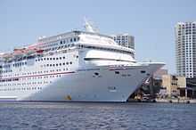
 The Carnival Inspiration docked at Port Tampa Bay. | |
| Location | |
| Country | United States |
| Location | Tampa |
| Details | |
| Opened | 1924 |
| Operated by | Tampa Port Authority |
| Type of harbor | Natural/Artificial |
| Size | appx. 5,000 acres |
| Channel depth | 43 feet |
| Statistics | |
| Vessel arrivals | 1,589 (FY2014) |
| Annual cargo tonnage | 6,890,250 (FY2014) |
| Annual container volume | 42,198 TEUs (FY2013); 197,818 tons (FY2014) |
| Value of cargo | $5 billion (2012) |
| Passenger traffic | 854,260 (FY2013) |
| Main exports | phosphate, fertilizer |
| Main imports | petroleum products, steel |
|
Website http://www.tampaport.com/ | |
Port Tampa Bay, known as the Port of Tampa until January 2014,[1] is the largest port in the state of Florida and is overseen by the Tampa Port Authority, a Hillsborough County agency. The port is located in Tampa, Florida near downtown Tampa's Channel District. The port directly accesses Tampa Bay on the western coast of the Florida Suncoast, and is approximately 25 sea miles from the Gulf of Mexico. The boundaries of the Port district includes parts of Tampa Bay, Hillsborough Bay, McKay Bay, Old Tampa Bay and the Hillsborough River. The port serves container ships and cruise lines.
Port Tampa Bay currently ranks 16th in the United States by tonnage and first in Florida.[2] Cargo shipping includes bulk and tanker ships, as well as roll-on/roll-off ships and container cargo ships. The port additionally operates ship repair facilities. Currently connected to major Asian container ports, with global connections, the port is focused on growing its container trade. Millions of dollars in infrastructure improvements are underway or in the planning phase.
Cargo shipping
Weekly containerized cargo service is available at Port Tampa Bay. Ports America operates two container berths, three gantry cranes, a 100 ton Mobile Harbor Crane and a container terminal. Zim American Integrated Shipping Company has been providing global connections to Port Tampa Bay for the past ten years. MSC has recently partnered with Zim on a joint service connecting Port Tampa Bay to an additional global network. The port's longest running container carrier Tropical Shipping recently ceased operations at Port Tampa Bay. Horizon Lines also made a short lived attempt to provide service to the port but quickly pulled the plug. Currently 3,000 to 4,250 TEU containerships regularly call Port Tampa Bay.
The port is also home to Foreign Trade Zone #79. Foreign Trade Zone No. 79 assists companies in Tampa Bay and along the I-4 Corridor in importing, exporting, manufacturing, and distribution activities.
| Part of the series on |
Florida Ports |
| Port Tampa Bay |
|
Port of Apalachicola |
| Wikipedia:WikiProject Florida |
Cruise ships

Tampa is also one of America's most popular departure ports for western Caribbean cruises. Four cruise lines sail from the port: Carnival Cruise Lines, Royal Caribbean International, Holland America Line, and Norwegian Cruise Line. The cruise port has been growing since the 1990s. It has 3 cruise terminals. Nearby attractions include Channelside, The Florida Aquarium, and Ybor City.
Access
The cruise terminal and port headquarters are located along Channelside Drive.[3][4] The nearest major highway to the port is the Lee Roy Selmon Expressway, which runs along the northern edge of the port. Elevated, reversible lanes on the expressway run from Meridian Avenue (three blocks west of the cruise terminal) to Interstate 75 and the suburb of Brandon.
A significant amount of truck traffic to and from the port once traveled on the urban streets of Ybor City, one of just two National Historic Districts in Florida.[5] The Interstate 4 – Selmon Expressway Connector, completed in 2013, is a 1.1-mile (1.8 km) highway which has exclusive truck lanes to route truck traffic from Interstate 4 directly to Port Tampa Bay, allowing thousands of trucks each day to bypass city roads and travel directly between the Port and the interstate system.[5][6][7]

History
Tampa Bay has been used as a wide, safe harbor ever since it was first mapped by Spanish explorers in the 16th century. However, it also presented a navigability problem as the muddy bay bottom is shallow and unpredictable. The bay is less than 25 feet (7.6 m) deep almost everywhere and considerably less than that in many places, including the silty approach to the city of Tampa in McKay Bay.[8] By the late 19th century, typical cargo ships had grown large enough that most could not enter upper Tampa Bay. Ships would anchor a mile or more from shore and goods and passengers were brought to and from the town via smaller boats.
In 1899, the U.S. Congress authorized the dredging of a 27 feet (8.2 m) deep channel to Port Tampa, Henry Plant's rail-to-ship facility on the west side of the Tampa peninsula. In 1917, another channel was dredged from the mouth of Tampa Bay to Tampa's main port near downtown, instantly making the Port of Tampa an important shipping facility.[9] Because the sandy bottom results in these channels slowly filling in over time, the U.S. Army Corps of Engineers regularly re-dredges and widens the channels to a depth of up to 47 feet (14 m), a process which produces about 1 million cubic yards of sediment every year.[10] This material has been used to create of several small fill islands in the bay along the approach to Port Tampa Bay.
Shipping and support facilities once occupied much of the waterfront land in and around downtown Tampa. Since the 1950s, most port operations except cruise ship terminals have moved just east and southeast of downtown, freeing Tampa's waterfront for other uses.
References
- ↑ http://www.tampabay.com/news/business/port-of-tampa-gets-new-name-port-tampa-bay/2162177
- ↑ "U.S. Port Ranking by Cargo Volume 2006". American Association of Port Authorities. Retrieved 2009-01-27.
- ↑ "About the Tampa Port Authority". Retrieved 6 March 2013.
- ↑ "Tampa Cruise Terminal". Retrieved 6 March 2013.
- ↑ 5.0 5.1 "I-4 / Selmon Expressway Connector (new road)". Retrieved 6 March 2013.
- ↑ "Transportation Recovery-Interstate 4/Selmon Expressway Connector". Retrieved 6 March 2013.
- ↑ Judy, Scott. "Tampa's Elevated Connector Tests the Team". Engineering News-Record. McGraw Hill. Retrieved 6 March 2013.
- ↑ http://dl.nwrc.gov/net_prod_download/public/gom_net_pub_products/MAP/1879chart_tampa.jpg
- ↑ "Corps, Port Consider Channel Widening Options". Baysoundings.com. Retrieved 2011-04-17.
- ↑ http://www.tbep.org/pdfs/ctc/Dredging-and-Dredged-Material-Management.pdf
External links
![]() Media related to Port Tampa Bay at Wikimedia Commons
Media related to Port Tampa Bay at Wikimedia Commons