Port Campbell
| Port Campbell Victoria | |||||||
|---|---|---|---|---|---|---|---|
|
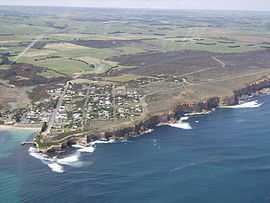
Aerial photograph of Port Campbell | |||||||
 Port Campbell | |||||||
| Coordinates | 38°37′0″S 142°59′0″E / 38.61667°S 142.98333°ECoordinates: 38°37′0″S 142°59′0″E / 38.61667°S 142.98333°E | ||||||
| Population | 599 (2006 census)[1] | ||||||
| Postcode(s) | 3269 | ||||||
| Location |
| ||||||
| LGA(s) | Corangamite Shire | ||||||
| State electorate(s) | Polwarth | ||||||
| Federal Division(s) | Wannon | ||||||
| |||||||
Port Campbell /pɔːt ˈkæmbəl/[2] is a coastal town in Victoria, Australia. The town is on the Great Ocean Road, west of the Twelve Apostles, in the Shire of Corangamite. At the 2006 census, Port Campbell had a population of 599.[1]
History
The town was settled in the 1870s, with the first wharf being built in 1880. Port Campbell Post Office opened on 19 March 1874. It was renamed Port Campbell West in 1881 when a new Port Campbell office opened near the wharf.[3] At the 2001 census, Port Campbell had a population of 372. At the 2006 census, Port Campbell had a population of 599. At the 2011 census, Port Campbell had a population of 618.
Port Campbell is now a popular tourist destination for visiting the Twelve Apostles, located 12 kilometres to the east of the town and the Port Campbell National Park,[4] as well as maintaining a small crayfishing community.
Gallery
-
The town seen from the war memorial lookout
-
The headland of the harbour at Port Campbell
-
The fishing docks
-
Lord Street
References
- ↑ 1.0 1.1 Australian Bureau of Statistics (25 October 2007). "Port Campbell (State Suburb)". 2006 Census QuickStats. Retrieved 2007-10-01.
- ↑ Butler, S., ed. (2009). "Port Campbell". Macquarie Dictionary (5th ed.). Sydney: Macquarie Dictionary Publishers Pty Ltd. 1952 pages. ISBN 978-18-7642-966-9.
- ↑ Premier Postal History, Post Office List, retrieved 2008-04-11
- ↑ "Port Campbell". Visit Victoria. Tourism Victoria. Retrieved 5 December 2013.
External links
![]() Media related to Port Campbell, Victoria at Wikimedia Commons
Media related to Port Campbell, Victoria at Wikimedia Commons
- Port Campbell - Official tourism website.
- Official Website for 12 Apostles Region of Victoria
| ||||||||||
| ||||||


