Port-Gentil
| Port-Gentil Mandji | |
|---|---|
 | |
 Port-Gentil Location in Gabon | |
| Coordinates: 0°43′S 8°47′E / 0.717°S 8.783°E | |
| Country |
|
| Province | Ogooue-Maritime |
| Department | Bendje Department |
Port-Gentil or Mandji (1993 est. pop. 80,000) is the second-largest city of Gabon, and its leading seaport. It is the center of Gabon's petroleum and timber industries. Although it lies inshore, the nearby mainland is a remote forest area and it is not connected by road to the rest of the nation. The city lies close to Cape Lopez, the westernmost point in Gabon.
The settlement was established on Mandji Island in the delta of the Ogooué River by the French, who signed a treaty with the Orungu people in 1873. It was used as a base for the expeditions of de Brazza into the interior, then in 1894 a customs post was set up, becoming the nucleus of a trading center that included Hatton & Cookson, John Holt, Woermann, Société du Haut-Ogooué, and Compagnie d'Exploitations Forestières Africaines. The main products were initially rubber and ivory, gradually supplemented by woods, particularly okoumé for plywood.

The town was named after the French colonial administrator Émile Gentil in 1900. After World War I it became a port for timber, but it grew rapidly only after Elf began oil exploration in the area. It received its first bank branch when Bank of West Africa (BAO), opened a branch there in 1928.
A 1947 population of 4,500 grew to 21,000 by 1960. An oil refinery was established by SOGARA in the 1960s, with natural gas added in 1968.
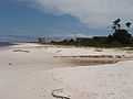
The town is now known for its hotels and its nightlife, while attractions include the St Louis Church (built in 1927), a zoo, a casino, beaches and a golf course, as well as the wildlife in local swamps.
Climate
Köppen-Geiger climate classification system classifies its climate as tropical wet and dry (Aw).
The highest recorded temperature was 43 °C (109 °F) on 21 February 1976; the lowest recorded temperature was −2 °C (28 °F) on 24 November 1979.[1]
| Climate data for Port-Gentil | |||||||||||||
|---|---|---|---|---|---|---|---|---|---|---|---|---|---|
| Month | Jan | Feb | Mar | Apr | May | Jun | Jul | Aug | Sep | Oct | Nov | Dec | Year |
| Record high °C (°F) | 38 (100) |
43 (109) |
43 (109) |
40 (104) |
40 (104) |
37 (99) |
37 (99) |
40 (104) |
40 (104) |
38 (100) |
40 (104) |
39 (102) |
43 (109) |
| Average high °C (°F) | 29.5 (85.1) |
30.2 (86.4) |
30.3 (86.5) |
30 (86) |
29 (84) |
26.7 (80.1) |
25.9 (78.6) |
27.4 (81.3) |
27.7 (81.9) |
28.3 (82.9) |
28.6 (83.5) |
29 (84) |
28.5 (83.3) |
| Daily mean °C (°F) | 26.9 (80.4) |
27.3 (81.1) |
27.3 (81.1) |
27.1 (80.8) |
26.6 (79.9) |
24.4 (75.9) |
23.5 (74.3) |
24.7 (76.5) |
25.4 (77.7) |
25.9 (78.6) |
26.1 (79) |
26.5 (79.7) |
26.0 (78.8) |
| Average low °C (°F) | 24.2 (75.6) |
24.4 (75.9) |
24.3 (75.7) |
24.2 (75.6) |
24.1 (75.4) |
22 (72) |
21.1 (70) |
21.9 (71.4) |
23 (73) |
23.5 (74.3) |
23.5 (74.3) |
24 (75) |
23.3 (73.9) |
| Record low °C (°F) | 0 (32) |
7 (45) |
12 (54) |
12 (54) |
12 (54) |
12 (54) |
15 (59) |
8 (46) |
0 (32) |
12 (54) |
−2 (28) |
10 (50) |
−2 (28) |
| Average precipitation mm (inches) | 247.8 (9.756) |
177.8 (7) |
266.8 (10.504) |
299.3 (11.783) |
150.6 (5.929) |
11.5 (0.453) |
3.4 (0.134) |
5 (0.2) |
31.8 (1.252) |
179.9 (7.083) |
352.2 (13.866) |
227.1 (8.941) |
1,953.2 (76.898) |
| Avg. precipitation days | 14.8 | 12.7 | 16.4 | 15.5 | 10.2 | 0.9 | 0.5 | 3.4 | 9.0 | 17.4 | 19.6 | 13.9 | 134.3 |
| Average relative humidity (%) | 84 | 84 | 83 | 84 | 85 | 84 | 83 | 82 | 82 | 84 | 86 | 84 | 84 |
| Mean monthly sunshine hours | 150.4 | 160.8 | 154.5 | 151.5 | 147.8 | 156.3 | 163.1 | 135.3 | 125.7 | 116.1 | 115.1 | 147.2 | 1,723.8 |
| Source #1: NOAA[2] | |||||||||||||
| Source #2: Voodoo Skies for record temperatures[1] | |||||||||||||
Transportation
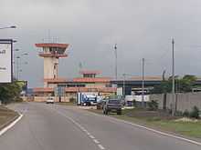
Port Gentil is technically on an island, and no bridge connects it to the mainland. The limited number of paved roads within the city are also poorly maintained. It has an airport, Port-Gentil International Airport, serving as the main channel of transportation with the world. Regular flights connect it with Libreville, capital of Gabon. Oil company charters to other destinations are a regular sight from the airport.
Notable residents
- Stephane Lasme, professional basketball player
Gallery
References
- ↑ 1.0 1.1 "Port-Gentil, Gabon". Voodoo Skies. Retrieved 4 November 2013.
- ↑ "Port-Gentil Climate Normals 1961–1990". National Oceanic and Atmospheric Administration. Retrieved March 8, 2015.
- David E. Gardinier, Historical Dictionary of Gabon, 2nd ed. (The Scarecrow Press, 1994) p. 275–276
- Port Gentil - the world's most expensive city, Time Magazine online, Mar 16 2007