Porsangerfjorden
| Porsangerfjorden Porsáŋgguvuotna Porsanginvuono | |
|---|---|
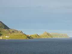 View of the western side of the fjord | |
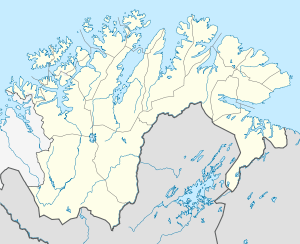 Porsangerfjorden Location in Finnmark | |
| Location | Nordkapp and Porsanger, Finnmark |
| Coordinates | 70°11′54″N 25°04′33″E / 70.1983°N 25.0758°ECoordinates: 70°11′54″N 25°04′33″E / 70.1983°N 25.0758°E |
| Basin countries | Norway |
| Max. length | 123 kilometres (76 mi) |
The Porsangerfjorden (Northern Sami: Porsáŋgguvuotna; Kven: Porsanginvuono) is a fjord in Finnmark county, Norway. The 123-kilometre (76 mi) long fjord is Norway's fourth longest fjord.[1] It is located in the municipalities of Nordkapp and Porsanger and it empties out into the Barents Sea. The large island of Magerøya and the Porsanger Peninsula lie along the western shore of the fjord, and the Sværholt Peninsula lies along the eastern shore of the fjord. Helnes Lighthouse sits at the mouth of the fjord, on the western coast.
The village of Lakselv sits at the innermost part (southern part) of the fjord. Other settlements along the fjord include the villages of Brenna, Børselv, Indre Billefjord, Kistrand, Olderfjord, Repvåg, and Nordvågen. The town of Honningsvåg is also located near the mouth of the fjord. There are many islands inside the fjord, notably Tamsøya and Reinøya.
Name
The fjord is officially named Porsangerfjorden in the Norwegian language. It is also known informally as Porsangen, but that is not an official name. The Northern Sami language version of the name is Porsáŋgguvuotna and the Kven language version of the name is Porsanginvuono.[2]
Media gallery
-

Orkkanluokta in Porsangerfjorden
-

View near Kistrand
-

View of the coastline
-

View of the fishing village of Repvåg
References
- ↑ http://www.porsanger.kommune.no/index.php?id=127685&showtipform=1&cat=20898&gb=
- ↑ "Porsangerfjorden" (in Norwegian). yr.no. Retrieved 2013-02-18.