Population density


Population density (in agriculture : standing stock and standing crop) is a measurement of population per unit area or unit volume; it is a quantity of type number density. It is frequently applied to living organisms, and particularly to humans. It is a key geographic term.[1]
Lists of population density of different countries are below. Lists of other population densities are in See also section.
Biological population densities
Population density is population divided by total land area or water volume, as appropriate.[1]
Low densities may cause an extinction vortex and lead to further reduced fertility. This is called the Allee effect after the scientist who identified it. Examples of the causes in low population densities include:[2]
- Increased problems with locating sexual mates
- Increased inbreeding
Human population density

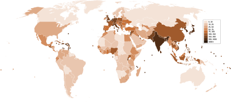
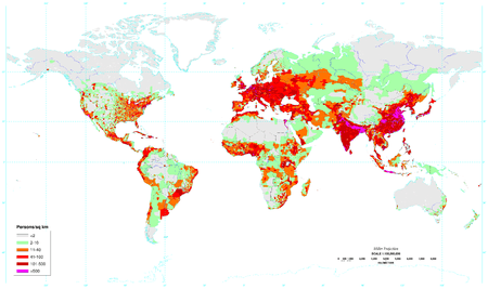
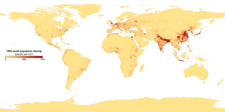
For humans, population density is the number of people per unit of area, usually quoted per square kilometer or square mile (which may include or exclude, for example, areas of water or glaciers). Commonly this may be calculated for a county, city, country, another territory, or the entire world.
The world's population is around 7 billion,[3] and Earth's total area (including land and water) is 510 million square kilometers (197 million square miles).[4] Therefore the worldwide human population density is around 7 billion ÷ 510 million = 13.7 per km2 (35 per sq. mile). If only the Earth's land area of 150 million km2 (58 million sq. miles) is taken into account, then human population density increases to 47 per km2 (120 per sq. mile). This includes all continental and island land area, including Antarctica. If Antarctica is also excluded, then population density rises to over 50 people per km2 (over 130 per sq. mile).[1] However over half of the Earth's land mass consists of areas inhospitable to human habitation, such as deserts and high mountains, and population tends to cluster around seaports and fresh water sources. Thus this number by itself does not give any helpful measurement of human population density.
Several of the most densely populated territories in the world are city-states, microstates, and dependencies.[5][6] These territories have a relatively small area and a high urbanization level, with an economically specialized city population drawing also on rural resources outside the area, illustrating the difference between high population density and overpopulation.
Cities with high population densities are, by some, considered to be overpopulated, though this will depend on factors like quality of housing and infrastructure and access to resources.[7] Most of the most densely populated cities are in southern and eastern Asia, though Cairo and Lagos in Africa also fall into this category.[8]
City population and especially area are, however, heavily dependent on the definition of "urban area" used: densities are almost invariably higher for the central city area than when suburban settlements and the intervening rural areas are included, as in the areas of agglomeration or metropolitan area, the latter including sometimes neighboring cities. For instance, Milwaukee has a greater population density when just the inner city is measured, and the surrounding suburbs excluded.[9]
In comparison, based on a world population of seven billion, the world's inhabitants, as a loose crowd taking up ten square feet (one square metre) per person (Jacobs Method), would occupy a space a little larger than Delaware's land area.
Most densely populated countries/regions
By inhabited region
| Region | Population | Area (km2) | Density (Pop. per km2) |
|---|---|---|---|
| Indo-Gangetic Plain (Pakistani Punjab to Bangladesh and Assam) | 1 billion | 1,000,000 | 1000 |
| Greater North China Plain | 600 million | 700,000 | 857 |
| Sichuan Basin | 110 million | 250,000 | 440 |
| Java Island | 145 million | 130,000 | 1115 |
| Taiheiyo Belt (Japan) | 85 million | 60,000 | 1417 |
| SE China coast (Guangdong, Hong Kong, Fujian) | 140 million | 100,000 | 1400 |
| Nile Delta | 50 million | 50,000 | 1000 |
| Southern India (Tamil Nadu, Pondicherry, Bengaluru, and Kerala) | 120 million | 170,000 | 706 |
| West Indian Coast (Maharashtra and Gujarat Coast) | 70 million | 100,000 | 700 |
| Colombian Andes (Colombia) | 40 million | 170,000 | 235 |
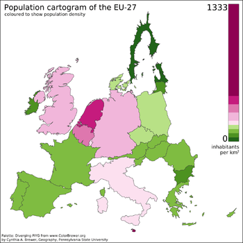
| Northern Europe (Benelux, North Rhine-Westphalia) | 44 million | 110,000 | 400 |
| NE US Coast | 45 million | 100,000 | 450 |
| S Central England | 40 million | 60,000 | 667 |
| Central Mexico | 40 million | 100,000 | 400 |
| Luzon Island | 50 million | 105,000 | 476 |
| South Korea | 50 million | 100,000 | 500 |
| Southeastern Brazil Coast | 50 million | 100,000 | 500 |
By political boundaries
| Rank | Country/Region | Population | Area (km2) | Density (Pop. per km2) |
|---|---|---|---|---|
| 1 | | 5,183,700 | 710 | 7301 |
| 2 | | 7,061,200 | 1,104 | 6396 |
| 3 | | 1,816,379 | 360 | 5045 |
| 4 | | 1,234,596 | 750 | 1646 |
| 5 | | 157,457,000 | 147,570 | 1067 |
| 6 | | 23,361,147 | 36,190 | 646 |
| 7 | | 1,288,000 | 2,040 | 631 |
| 8 | | 50,219,669 | 99,538 | 505 |
| 9 | | 4,966,000 | 10,452 | 475 |
| 10 | | 10,718,379 | 26,338 | 407 |
| Rank | Country/Region | Population | Area (km2) | Density (Pop. per km2) |
|---|---|---|---|---|
| 1 | 157,457,000 | 147,570 | 1067 | |
| 2 | | 23,361,147 | 36,190 | 646 |
| 3 | | 50,219,669 | 99,538 | 505 |
| 4 | 10,718,379 | 26,338 | 407 | |
| 5 | 16,760,000 | 41,526 | 404 | |
| 6 | 1,263,680,000 | 3,185,263 | 397 | |
| 7 | 10,413,211 | 27,750 | 375 | |
| 8 | 11,007,020 | 30,528 | 361 | |
| 9 | 127,290,000 | 377,944 | 337 | |
| 10 | 100,271,800 | 300,076 | 334 |
Other methods of measurement
Although arithmetic density is the most common way of measuring population density, several other methods have been developed to provide a more accurate measure of population density over a specific area.
- Arithmetic density: The total number of people / area of land (measured in square miles or square kilometers ).
- Physiological density: The total population / area of arable land.
- Agricultural density: The total rural population / area of arable land.
- Residential density: The number of people living in an urban area / area of residential land.
- Urban density: The number of people inhabiting an urban area / total area of urban land.
- Ecological optimum: The density of population that can be supported by the natural resources.
See also
- Demography
- Human geography
- Idealized population
- Optimum population
- Population bottleneck
- Population genetics
- Population health
- Population momentum
- Population pyramid
- Rural transport problem
- Small population size
- Distance sampling
- List of population concern organizations
Lists of entities by population density
- List of cities by population density
- List of city districts by population density
- List of European cities proper by population density
- List of islands by population density
- List of countries by population density
- List of U.S. states by population density
References
- ↑ 1.0 1.1 1.2 Matt Rosenberg Population Density. Geography.about.com. March 2, 2011. Retrieved on December 10, 2011.
- ↑ Minimum viable population size. Eoearth.org (March 6, 2010). Retrieved on December 10, 2011.
- ↑ U.S. & World Population Clocks. Census.gov. Retrieved on December 10, 2011.
- ↑ World. CIA World Handbook
- ↑ Department of Economic and Social Affairs Population Division (2009). "World Population Prospects, Table A.1" (PDF). 2008 revision. United Nations. Retrieved March 12, 2009.
- ↑ The Monaco government uses a smaller surface area figure resulting in a population density of 18,078 per km2
- ↑ Human Population. Global Issues. Retrieved on December 10, 2011.
- ↑ The largest cities in the world by land area, population and density. Citymayors.com. Retrieved on December 10, 2011.
- ↑ The Population of Milwaukee County. Wisconline.com. Retrieved on December 10, 2011.
External links
| ||||||||||||||||||||||||||||||||||||||||||
| |||||||||||||||||||||||||

| ||||||
| ||||||||||||||||||||||||||||||||
| ||||||||||||||||||||||||||||||||||