Pontiac, Missouri
| Pontiac, Missouri | |
|---|---|
| Community | |
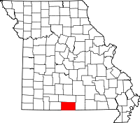
 Pontiac, Missouri Location of Pontiac, Missouri | |
| Coordinates: 36°30′56″N 92°36′14″W / 36.51556°N 92.60389°WCoordinates: 36°30′56″N 92°36′14″W / 36.51556°N 92.60389°W[1] | |
| Country | U. S. A. |
| State | Missouri |
| County | Ozark County |
| Elevation[1] | 251 m (823 ft) |
| Time zone | CST (UTC-6) |
| • Summer (DST) | CDT (UTC-5) |
| Zip Code | 65729 |
Pontiac is an unincorporated community in southern Ozark County, Missouri. It lies six miles south of Isabella and 18.5 miles southwest of Gainesville.[2] It is located on the northeast shore of Bull Shoals Lake.
A post office was established in 1887 or 1888 and named Pontiac for Pontiac, Michigan and the Ottawa Indian chief, Pontiac.[3]
The town is located on a ridge above the lake at an elevation of about 820 feet. The lake has a normal surface elevation of 654 feet.[1] The town consists of a post office, a marina and campgrounds on the lake, a restaurant, and a church. Pontiac is accessed via state route W from U.S. Route 160 east of Isabella.[4]
Just across the Arkansas border is Price Place, which is physically separated from Arkansas by the waters of Bull Shoals Lake. Residents of Price Place bond with those of Pontiac to operate the volunteer fire department. Price Place also has a small church which is over 100 years old and is being refurbished.

References
- ↑ 1.0 1.1 1.2 Isabella, MO, 7.5 Minute Topographic Quadrangle, USGS, 2004
- ↑ Moser, Paul, A Directory of Towns, Villages, and Hamlets Past and Present of Ozark County, Missouri
- ↑ Ozark County Place Names, 1928-1945, The State Historical Society of Missouri
- ↑ Ava, Missouri, 30x60 Minute Topographic Quadrangle, USGS, 1985
| |||||||||||||||||||||||||||||