Polzeath
| Polzeath | |
| Cornish: Polsegh | |
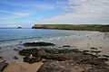
 The Beach at Polzeath |
|
 Polzeath |
|
| Population | 1,449 (2001 Census, includes Trebetherick) |
|---|---|
| OS grid reference | SW937788 |
| Unitary authority | Cornwall |
| Ceremonial county | Cornwall |
| Region | South West |
| Country | England |
| Sovereign state | United Kingdom |
| Post town | POLZEATH |
| Postcode district | PL27 |
| Dialling code | 01208 |
| Police | Devon and Cornwall |
| Fire | Cornwall |
| Ambulance | South Western |
| EU Parliament | South West England |
| UK Parliament | North Cornwall |
Coordinates: 50°34′25″N 4°54′55″W / 50.57356°N 4.91514°W

Polzeath (/pəlˈzɛθ/) (Cornish: Polsegh, meaning dry creek) is a small seaside resort in the civil parish of St Minver[1] in Cornwall, England, United Kingdom. It is approximately 6 miles (9.7 km) north west of Wadebridge on the Atlantic coast.[2]
Polzeath has a sandy beach and is popular with holiday-makers and surfers. The beach is 1,500 feet (460 m) wide and extends 1,200 feet (370 m) from the seafront at low water; however, most of the sand is submerged at high water.[2] At exceptionally high spring tides the sea floods the car park at the top of the beach.
Polzeath beach is patrolled by lifeguards during the summer and is described on the RNLI website as : ... a wide, flat beach with some shelter from winds, it sees good quality surf and is quite often extremely crowded.[3]
Dolphins may sometimes be spotted in the bay and the coastline north of Polzeath is a good area for seeing many types of birds including corn buntings and puffins.[4]
The main street runs along the seafront and has a parade of shops catering for holidaymakers and residents. There are pubs, cafés, restaurants, a caravan site and several camping sites in the immediate area. The road rises up steep hills at both ends of the seafront; towards the village of Trebetherick to the southwest and New Polzeath to the northeast.[2]
There are Police reports of anti-social behavior, theft, burglary, violent and sexual offences.[5]
History
In 1911 a Methodist chapel was built on the road towards Trebetherick at Chapel Corner. The original building was demolished in 1932 when the village street was widened. A new village hall was opened on 15 April 1933.[6]
A stream rises near St Minver 2 miles (3.2 km) to the south. Before reaching Polzeath, it is joined by a tributary which rises north of Pityme. Shilla Mill at the edge of Polzeath, stands at the confluence of the streams.[2] Built around 1590 it ceased working as a mill in 1885 and was converted into a house.
Until 1934 the main street through the village crossed the stream by means of a ford. A footbridge was provided for pedestrians which was sometimes washed away by winter storms. In 1934 the road bridge was built.
Economy
Tourism developed in the 19th and 20th centuries to be the most significant part of the local economy.[7]
Tristan Stephenson a mixologist and drinks industry expert became a director of Surfside Cafe on the beach of Polzeath in 2014.[8]
Literary associations
Polzeath was a favourite haunt of the poet laureate, Sir John Betjeman, and is celebrated in some of his verse. He is buried in the churchyard of St Enodoc Church, Trebetherick. Another poet, Laurence Binyon, wrote the Remembrance Day ode For the Fallen in 1914 while sitting on The Rumps, Polzeath or "Polseath" as it was called, during World War I.
In the first of Enid Blyton's Famous Five novels, the eponymous children express disappointment that their holiday will not, as usual, be spent at Polzeath.[9] The author Joolz Denby lived in a caravan in Polzeath for a year while researching her novel Borrowed Light, published in 2006. The novel is set in Polzeath, though the village's name is changed to Polwenna.
The cartoonist Posy Simmonds created a fictitious place in Cornwall called "Tresoddit". When the BBC made the short film Tresoddit for Easter in 1991, it was filmed in and around Polzeath.
Gallery of images
-

Sunset over the bay towards Pentire Point and Newland, the island
-

View of the beach from New Polzeath with Stepper Point across the bay
-
Surfers at Polzeath
-
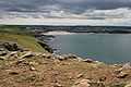
View of Polzeath from Pentire Point
-

Another general view of the beach from the north-east side
-
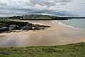
View across Polzeath beach from the north-east
-

View of Pentire Point from the beach car park
-

View of Pentire Point taken from Polzeath
-
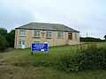
Polzeath Methodist Church
-

Shilla Mill cattle grid stream crossing
See also
- Trebetherick
- Wadebridge
- Pentire Point
- River Camel
References
- ↑ Cornwall Council online mapping. Retrieved June 2010
- ↑ 2.0 2.1 2.2 2.3 Ordnance Survey: Landranger map sheet 200 Newquay & Bodmin ISBN 978-0-319-22938-5
- ↑ RNLI Lifeguards, Polzeath. Retrieved June 2010
- ↑ RSPB website; Pentire and Rumps Point. Retrieved June 2010
- ↑ http://www.police.uk/devon-and-cornwall/134.10/crime/stats/
- ↑ Drew, Alan (1993). The Charm of North Cornwall. Ticehurst: Triskele Publications. p. 36. ISBN 0-9520627-0-4.
- ↑ http://www.jstor.org/discover/10.2307/40564889?sid=21105568528313&uid=3739256&uid=2&uid=4
- ↑ "Fluid Movement | About". fluid-movement.com. 2015. Retrieved 5 January 2015.
- ↑ Blyton, Enid (1942). Five on a Treasure Island. ISBN 9781844569595.
External links
| Wikimedia Commons has media related to Polzeath. |
- Polzeath at DMOZ
- Local government census report, 2004
- Cornwall Record Office Online Catalogue for Polzeath
| ||||||||||||||||||||||||||