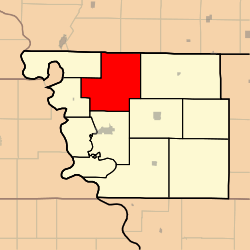
Polk Township, Atchison County, Missouri
| Polk Township | |
|---|---|
| Township | |
 | |
| Coordinates: 40°31′16″N 095°30′38″W / 40.52111°N 95.51056°WCoordinates: 40°31′16″N 095°30′38″W / 40.52111°N 95.51056°W | |
| Country | United States |
| State | Missouri |
| County | Atchison |
| Area | |
| • Total | 62.32 sq mi (161.41 km2) |
| • Land | 62.32 sq mi (161.41 km2) |
| • Water | 0 sq mi (0 km2) 0% |
| Elevation[1] | 994 ft (303 m) |
| Population (2010) | |
| • Total | 226 |
| • Density | 4/sq mi (1.4/km2) |
| FIPS code | 29-58700[2] |
| GNIS feature ID | 0766238 |
Polk Township is one of eleven townships in Atchison County, Missouri, United States. As of the 2010 census, its population was 226.[3]
Geography
Polk Township covers an area of 62.3 square miles (161.4 km2) and contains no incorporated settlements. It contains five cemeteries: High Creek, Linden, St. John's Lutheran, Grange Hall, and Steiner.
The streams of McElroy Creek, High Creek, West High Creek, and Hall Branch run through this township.
References
- ↑ "US Board on Geographic Names". United States Geological Survey. 2007-10-25. Retrieved 2008-01-31.
- ↑ "American FactFinder". United States Census Bureau. Retrieved 2008-01-31.
- ↑ "Geographic Identifiers: 2010 Demographic Profile Data (G001): Polk township, Atchison County, Missouri". U.S. Census Bureau, American Factfinder. Retrieved June 25, 2013.
External links
| |||||||||||||||||||||||||||||
